Download
1 / 16
160 likes | 186 Vues
This project aims to create a generalized hydrologic water budget for the watersheds in Cache Valley, UT/ID. By comparing the results with the existing groundwater model, it provides insights into the storage flux and aquifer recharge in the valley.

E N D
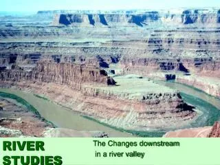
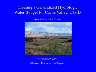
Creating a Generalized Hydrologic Water Budget for Cache Valley, UT/ID Presented by Tom Nelson November 29, 2007 GIS-Water Resources Final Project
Background • Groundwater flow model developed for Cache Valley by Kariya et al, but does not account for subsurface inflow • As a result, unrealistic boundary conditions applied to achieve model calibration
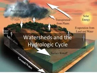
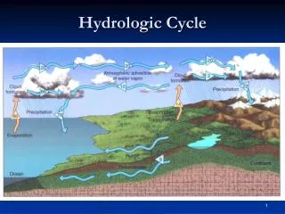
Background Karst Topography • Landscape shaped by the dissolution of carbonate rocks (e.g. limestone) • Interconnected subsurface channels that allow for rapid water transport
Objectives 1) Find the storage flux of Cache Valley aquifers by creating a generalized hydrologic budget for the watersheds that contain Cache Valley, UT/ID using the following equation: Aquifer Storage Flux = Stream Outflow + Evapotranspiration + Well Discharge – Stream/Spring Inflow - Precipitation 2) Compare results with water budget generated by Kariya et al model
Methods • Obtain stream discharge data to determine stream inflow/outflow • Determine area of Cache Valley watersheds using GIS analysis • Download and correct annual precipitation data • Add precipitation gage points onto map to perform a spatial analysis • Estimate an appropriate evapotranspiration rate for the valley • Obtain well discharge records for Cache Valley
Stream Inflow/Outflow • Cache Valley is contained within two watersheds: • 1) Middle Bear Watershed (northern half of valley) • 2) Middle Bear-Logan Watershed (southern half of valley) • Stream flow (Bear River) into the valley through the Alexander Dam • Stream flow (Bear River) out of the valley through the Cutler Dam
Inflow at the Alexander Dam • 19 years worth of Bear River daily discharge data available from Idaho Dept. of Water Resources • Average annual discharge of 1.4687x10^11 cubic meters
Outflow at Cutler Dam • Stream flow leaves Cache Valley through Cutler Dam • Discharge of Bear River measured approximately 0.25 miles downstream from Cutler Dam at 3 gages near Collinston, UT • 4-10 years of daily discharge data available • Combined Annual Discharge of 3.02295x10^11 cubic meters
Precipitation • Daily precipitation measurements from 9 stations in or near the Cache Valley watersheds • Correction factor applied due to missing data points in the data sets • A=(sum of existing values)/(total days of existing values) • Yearly Average=(A*total days in data set)/(total years in data set)
Precipitation • Precipitation stations added to GIS map as a feature dataset • Spatial Analysis performed using kriging interpolation method • Mean precipitation value of 19.4792 inches across the watersheds • Analysis of combined watershed drainage area gives an area of 5872.8 kilometers squared • Therefore, average annual precipitation in Bear Watersheds = 2.905708 x 10^9 cubic meters
Evapotranspiration • Monthly reference evapotranspiration data available for 2006-2007 from a climate station in North Logan • Estimating actual evapotranspiration: • Actual ET = (Multiplier) x (Sum of Reference Evapotranspiration for non-winter months (April-November)) • Actual ET = (0.5) x (0.870966 meters) = 0.435483 meters/year Total annual volume = (Actual ET) x (Area) = 2.5575 x 10^9 cubic meters
Well Discharge • Utah annual well discharge from Cache Valley • 1994-2005 average annual well discharge = 3.3304 x 10^7 cubic meters (Burden, C.B., et al) • Idaho annual well discharge from Cache Valley • Year 2000 annual well discharge = 3.10628 x 10^8 cubic meters (http://id.water.usgs.gov) • Combined annual well discharge from Cache Valley = 3.43919 x 10^8 cubic meters
Final Hydrologic Budget • Aquifer Storage Flux = Stream Outflow + Evapotranspiration + Well Discharge – Stream/Spring Inflow – Precipitation Aquifer Storage Flux = Subsurace Inflow – Subsurface Outflow • Annual Cache Valley Aquifer Storage Flux = 1.539017 x 10^11 cubic meters per year
Comparison with Kariya et al Groundwater Model • Kariya’s model assumes that nearly all of the aquifer recharge is due to seepage from irrigation canals and precipitation • This causes a lack of recharge into the valley, and as a result, the annual aquifer recharge is only 65% that of the annual aquifer discharge • In 2003, Myers showed that aquifer recharge from streams is negligible • From estimated water budget: • Precipitation – Evapotranspiration = 1.868558E+09 cubic meters • Assuming 50% runoff and 50% infiltration: • Infiltration from precipitation = 9.34279E+08 cubic meters • If parameters of Kariya’s model were followed in this case, there would be a recharge discrepancy of 1.52967E+11 cubic meters
Conclusions • The average annual storage flux for the aquifers of Cache Valley is approximately 1.539 x 10^11 cubic meters per year, although a more intensive study would have to be conducted to obtain a truly reliable value • The assumption of Kariya et al’s groundwater model for the valley, that the aquifers are recharged primarily through seepage from canals and precipitation, appears to significantly underestimate the volume and source of recharge
References • Burden, C.B., et al, 2006.Ground-Water Conditions in Utah, Spring 2006: Utah Department of Natural Resources, Water Resources Division, Report 47. • Kariya, K.A., Roark, D.M., Hanson, K.K.. Hydrology of Cache Valley, Cache County, Utah, and Adjacent Part of Idaho, with Emphasis on Groundwater. USGS Technical Pub. No. 108. 1994. • Myers, Barry. Simulation of Groundwater Flow in Cache Valley, Utah and Idaho. Utah State University Master’s Thesis. 2003. • http://climate.usurf.usu.edu/products/data.php • http://www.conservewater.utah.gov/et/etsite/default.asp?NorthLoganGreenvilleFarm.htm • http://id.waterusgs.gov/public/water.use.2000.xls • http://www.idwr.idaho.gov/gisdata/mapserver.htm • http://www.waterrights.utah.gov/cgi-bin/gageview.exe?Startup