Download
1 / 6
60 likes | 213 Vues
GEOSS Architecture for the Use of Satellites for Disaster Management and Risk Assessment. Karen Moe/NASA Earth Science Technology Office Presented at CEOS-WGISS-32 Budapest, Hungary September 27, 2011. GEOSS Architecture for Satellite Support for Disaster Management & Risk Assessment.

E N D
GEOSS Architecture for the Use of Satellites for Disaster Management and Risk Assessment Karen Moe/NASA Earth Science Technology Office Presented at CEOS-WGISS-32 Budapest, Hungary September 27, 2011
GEOSS Architecture for Satellite Support for Disaster Management & Risk Assessment WGISS People – Sensors – Data – Processes – Decision Support WGISS-32 Budapest, Hungary
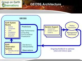
GA.4.Disasters Agenda • GA.4.Disasters – GEOSS Architecture for the Use of Satellites for Disaster Management and Risk Assessment • Project Purpose • Status • Disasters SBA Overview – Andrew Eddy • Enterprise Architecture Overview – John Evans • Discussion on WGISS ‘expected outcomes’ • Draft Enterprise Architecture Outline – John Evans • Next Steps WGISS-32 Budapest, Hungary
Purpose – GA.4.Disasters WGISS Project • Work jointly with the CEOS Disasters SBA team to develop the GEOSS enterprise architecture for managing distributed systems and web services for disaster management. • I: Answer questions regarding role of information systems and services in support of disaster management & risk assessment • Clarify scope of the disaster management enterprise • Promote a common understanding of its components and roles • Identify relationship of ongoing activities to the enterprise as a whole (shortfalls, gaps, redundancies) • II: Use enterprise architecture to guide implementation of proof-of-concept prototypes • Refine the enterprise architecture • Capture lessons learned and recommend standards Scope WGISS-32 Budapest, Hungary
GA.4.Disasters Status • Project start: June 2011, Serhiy Skakun & Karen Moe co-leads • Team established July 2011 • 22 on mailing list from 9 CEOS agencies, including members from Disasters SBA and International Charter, IC) • WGISS GA.4.Disasters web site • 2 telecons, several interviews (IC processes, Disasters SBA results to date, CEOS Supersites) • Namibian Flood Pilot extension for 2012 flood season • Acquire near-real time data for risk assessment prior to flooding conditions • Explore product delivery for use directly in the field and the role of SERVIR-Africa node in Kenya • Calibrate models and compare to flood products from IC WGISS-32 Budapest, Hungary
GA.4.Disasters Agenda • GA.4.Disasters – GEOSS Architecture for the Use of Satellites for Disaster Management and Risk Assessment • Project Purpose • Status • Disasters SBA Overview – Andrew Eddy • Enterprise Architecture Overview – John Evans • Discussion on WGISS ‘expected outcomes’ • Draft Enterprise Architecture Outline – John Evans • Next Steps WGISS-32 Budapest, Hungary