Download
1 / 12
120 likes | 795 Vues
Geogrpahy and Early History of Africa

E N D
Creation Story of the Kikuyu • People from the land of Kenya • Called the Kikuyu • Used to explain how they are connected to the land • “This land I hand over to you. O man and woman it’s yours to rule and farm in peace, sacrificing only to me, your God, under my sacred tree.” • ?? Why do cultures have creation stories ??
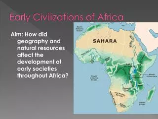
Vast Continent • Africa is the world’s second (2nd) largest continent • Location on the Earth: • Africa is located on the Equator (1/2 of the country is above and ½ below) • Between the Atlantic Ocean and the Indian Ocean • Mediterranean SeaandRed Sea border it as well
Explain the importance of being surrounded by oceans and seas.
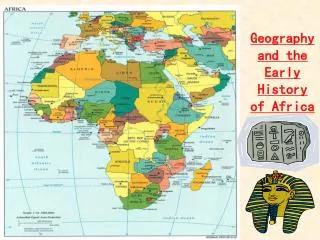
Regions of Africa • Main Regions of Africa are: • North Africa- from Morocco to Egypt. • West Africa- south of the Sahara Desert. • East Africa- Kenya, Uganda, Tanzania, etc… • Central Africa- Democratic Republic of the Congo (On the Equator). • Southern Africa- from the Atlantic Ocean to the Indian Ocean. • Look at page 62 in your textbook (Map of Africa) Geography helps to determine lifestyle and culture
Landforms of Africa • Most of Africa is plateau region • Plateau- large area of high flat, or gently rolling land • These plateaus are at different elevations throughout Africa • Escarpments- steep cliffs that divide the plateau from the coastal plain • Cataracts- large waterfalls and rapids • Changes in elevation cause the rivers to change course and direction • Explain how these cataracts would have made passage on the rivers problematic.
Great Rift Valley • Goes through the Eastern part of Africa • See page 61 in your textbook • It is a giant fault (break in the Earth’s crust) • From the Red Sea to the Zambezi River • High cliffs surround the valley and deposit rich soil into the valley • Many minerals and metals are also here • Costly and dangerous to mine these areas
Rivers • Rivers provide: • Fish, Irrigation, and transportation • Hydroelectric Power- energy produced from moving water This is how the power of water is used to make electricity What is important about this method ??
Rivers • The Nile- flows for 4,160 miles (largest in the world) • Played a major role in human development • Deposits rich soil onto the land for farming • Aswan Dam created in 1970 for hydroelectric power • Begins in the highlands of East Africa and flows northward across Africa
Rivers • Congo River- drains the area of Central Africa • Major source of hydroelectric power • Large parts are unable to be navigated • Niger River- starts in Sierra Leone and Guinea • Forms a large swamp by the Sahara • Major transportation route for ships and barges • Zambezi River- flows in Southern Africa • Flows over Victoria Falls
Natural Resources • Africa’s rivers provide many precious metals and minerals • Gold and Diamonds • Vast resources of precious minerals were the reason that European powers carved up Africa • Examples: • Oil, diamonds, gold, cobalt, copper • Resources are distributed unevenly through the country What problems would this have caused?