Download
1 / 9
90 likes | 205 Vues
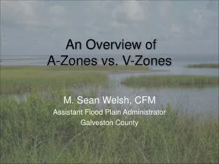
Overview of Updates to Evacuation Zones. Last Revised: Apr 2013. SLOSH Model. Storm Surge Inundation Map. What is Different?. Hurricanes Irene and Sandy Real events that can inform actual behavior, sheltering demand, mode of transit, and clearance times.

E N D
Overview of Updates to Evacuation Zones Last Revised: Apr 2013
SLOSH Model Storm Surge Inundation Map What is Different? • Hurricanes Irene and Sandy • Real events that can inform actual behavior, sheltering demand, mode of transit, and clearance times • 2010 SLOSH Model and 2011 Storm Surge • Model accounts for bigger, slower storms (represents recent storm characteristics) • Datum matches current standard • Resolution is 4 times greater • Best available land elevation data (LiDAR) • 2010 Census • New population estimates for geographic areas at risk
Maximum Surge Heights by Storm Bearing Storm bearings
Potential Building Impacts: Cat 1 HurricanesBuildings potentially impacted by worst-case surge based on hurricane bearing Gerritsen Beach Coney Island Gravesend
Irene – NNE bearing Sandy – WNW bearing (NW at landfall) Predicted storm tracks for both storms 70 hours before landfall
Bearing Based Proposal • Bearing has significant effect of storm surge • Allows for more flexibility in evacuation (less likely to over- or under- evacuate) • Storm track predictions are more accurate than predictions of intensity
Next Steps • Finalizing the zone boundaries • Identify HCFs within the new zones • Planning & education