Download
1 / 60
600 likes | 781 Vues
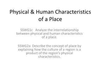
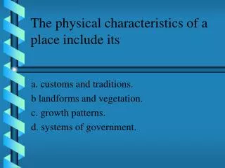
The physical characteristics of a place include its. a. customs and traditions. b landforms and vegetation. c. growth patterns. d. systems of government. B. Land forms and vegetation. The movement about which geographers talk usually refers to. a. environmental changes.

E N D
The physical characteristics of a place include its a. customs and traditions. b landforms and vegetation. c. growth patterns. d. systems of government.
The movement about which geographers talk usually refers to a. environmental changes. b. people, goods, and ideas. c. relative locations of places on the earth. d. birth and death rates and family size.
The customs, politics, and foods that make a place unique are called its natural features. political characteristics. human characteristics. human-environmental interactions.
A region can be defined as a group of places drained by a particular river. b. a group of places that have similar landform patterns. c. a group of places ruled by the same government. d. all of the above.
An internal force that helps create new landforms is mechanical weathering. volcanism. glacial movement. wind erosion.
Landforms are commonly classified according to differences in weathering. geological age. location. relief.
The largest canyons and deepest valleys were created by a. moving water. b. wind erosion. c. chemical weathering. d. plate tectonics.
The force that probably propels the movement of the earth’s gigantic rock plates is weathering. convection. frontal precipitation continental drift.
When geographers observe moraines—ridgelike piles of rock and debris—they conclude that a. a volcano erupted there. b. a fault lies nearby. c. a glacier once covered the area. d. chemical weathering has occurred.
The building of dams and canals to irrigate desert regions is an example of the geographic theme of place. region. location. human-environment interaction.
The five themes of geography a. are human-environment interaction, physical characteristics, human characteristics, absolute location, and relative location. b. form the core of geographic inquiry. c. relate to absolute and relative location. d. are based on hypotheses and scientific method.
Longitude is measured in degrees east or west of the a. Prime Meridian. b. Tropic of Cancer. c. Equator. d. Tropic of Capricorn.
The dense smog that blankets many cities today is a. a result of human-environment interaction. b. a process that shapes the earth’s surface. c. a human characteristic that makes these cities unique. d. determined by the absolute and relative locations of these cities.
Similar climates, vegetation, or landforms can be used to divide the earth into political regions. functional regions. formal regions. census regions.
Glaciers that melted and receded sometimes left behind moraines, which are areas of molten rock. breaks in the earth’s crust. ridgelike piles of rocks and debris. deep cracks in rocks and soil.
The theory of plate tectonics affirms that a. the earth’s outer shell is one solid piece of rock. b. the basic arrangement of oceans and continents is unchanging. c. large moving slabs of rock slide slowly over a layer of the mantle. d. the landscape of the ocean is the same as that on earth.
c. large moving slabs of rock slide slowly over a layer of the mantle.
The most common type of mechanical weathering takes place when a. carbon dioxide from the soil combines with water. b. caves are formed from the action of carbonic acid. c. rock and soil are moved to another place. d. frozen water causes frost wedging.
The greatest agent of erosion is a. wind. c. running water. b. sediment. d. acid rain.
The circle of volcanoes surrounding the Pacific Ocean is called the a. Ring of Fire. c. Pacific Plate. b. San Andreas Fault. d. Equator.
The spread of Christianity throughout Europe best reflects the geographic theme of a. location. c. region. b. place. d. movement.
Half of the globe is called a (hemisphere, great circle). hemisphere
The theory of (plate tectonics, mechanical weathering) says that the earth’s outer shell is not solid rock. plate tectonics
(Geography, Geology) is the study of where people, places, and things are located, the ways that different things relate to each other at specific places, and the ways that places connect with each other. geography
The (absolute, relative) location of Chicago is 42°N, 88°W. absolute
Rock layers that bend and buckle are called (folds, faults). folds
The (absolute, relative) locations on the earth can change. relative
Windblown deposits of mineral-rich dust and silt are called (loess, lava). loess
Lines of (latitude, longitude) are the imaginary lines that run from the North Pole to the South Pole. longitude
Acid rain is a kind of (chemical, mechanical) weathering. chemical
The (Equator, Prime Meridian) is an imaginary line that circles the globe halfway between the North Pole and the South Pole. Equator