Download
1 / 6
60 likes | 179 Vues
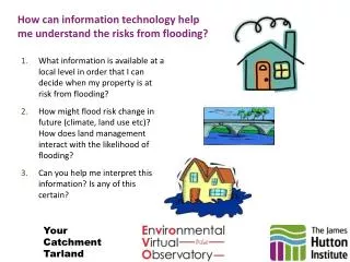
How can information technology help me understand the risks from flooding?. What information is available at a local level in order that I can decide when my property is at risk from flooding?

E N D
How can information technology help me understand the risks from flooding? • What information is available at a local level in order that I can decide when my property is at risk from flooding? • How might flood risk change in future (climate, land use etc)? How does land management interact with the likelihood of flooding? • Can you help me interpret this information? Is any of this certain? Your Catchment Tarland
Ask a question Upload info What do you think? How do I decide if my property is at risk from flooding? “We aim to make real-time, locally-relevant data accessible through the web for communities to become better informed about their environment”
Where and what are the data sources ? Data layers: Rain gauges Tarland Stream flow “River level data is an example of what can be readily achieved now live on the web and, given appropriate interpretation, can be highly informative about water quantity and quality questions from communities” Webcams Soil moisture Aboyne River Dee
“Flood extent analysis from web cam images can be used to calibrate data for current (river levels), recent (soil moisture) and near-future (rain forecasting) conditions. Together this system will ‘learn’ to improve local flood predictions” What do those river levels mean for where I live? Data layers: Rain gauges Stream flow Webcams What are you interested in? Soil moisture Forecast Analyse historical images River Dee
What does this mean? Animate prediction Chance of this area flooding? Use Slider What does this mean? Mouse over graph Very low Very High Scenario 1: Climate change affects runoff Scenario 2: A change in land management occurs here Can the system learn what the future holds as the catchment land use and climate changes? Your Flood risk prediction #1 “A goal is for scientific models to be applied in the background to aid future predictions with respect to changes in climate, land use and management. These results will simply be displayed on a probability basis”
My house! Who is going to help me if I don’t understand it? “Online tools will help select levels of user interpretation with explanatory graphics and video files. There will be a link through the local website to the national Environmental Virtual Observatory web portal” What does a 100 year flood mean?