Trigonometry and the GPS
70 likes | 649 Vues
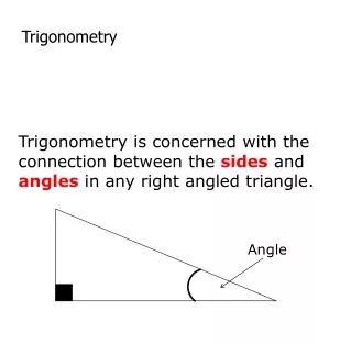
Trigonometry and the GPS. Lannie Su. Trigonometry and map-making. To draw a map, we need to know the distance. Drawing lines, and using the concept of trigonometry to calculate the distances. Sin, Cos, Tan

Trigonometry and the GPS
E N D
Presentation Transcript
Trigonometry and the GPS LannieSu
Trigonometry and map-making • To draw a map, we need to know the distance. • Drawing lines, and using the concept of trigonometry to calculate the distances. • Sin, Cos, Tan • Trigonometry is the most accurate to calculate and eliminate the distances between in order to make the map
Creative of Map • Calculating places between places, they used the original three point, and further out to other points. • Then, they came out with the map of the whole world.
First discovery & History • The original Base Line for the Ordnance Survey was about seven kilometers long and was set up in 1784 in West London. • Use triangulate across water. Ex: English Channel, one of the first uses of triangulation calculating the distances. • The Ancient Greeks had measured the distance of the horizon, and that figured out the diameter of the Earth.
Trigonometry and GPS • The Global Positioning System was originally developed by the United States Government for military use. • The GPS consists of 24 GPS satellites each orbiting the Earth twice a day at a height of about 20000 kilometers. • Each GPS satellites and every GPS receiver contains a clock, and they all set about the same time.
Trigonometry and GPS • The signal travels at the speed of light, means that the time it reaches your GPS receiver, and there will be the time differences. • The time differences can let us calculate the distance between the GPS satellite and GPS receiver.