Download
1 / 11
110 likes | 248 Vues
Validation of CIRA Tropical Cyclone Algorithms. Julie Demuth, Mark DeMaria, John Knaff, Kotaro Bessho, Kimberly Mueller, and Ray Zehr. CoRP Satellite Calibration and Validation Symposium 14 July 2005. Outline. AMSU intensity and wind radii estimation M. DeMaria, J. Demuth, J. Knaff

E N D
Validation of CIRA Tropical Cyclone Algorithms Julie Demuth, Mark DeMaria, John Knaff, Kotaro Bessho, Kimberly Mueller, and Ray Zehr CoRP Satellite Calibration and Validation Symposium 14 July 2005
Outline • AMSU intensity and wind radii estimation • M. DeMaria, J. Demuth, J. Knaff • new datasets • different methods • new estimation models • AMSU 2-D surface wind retrieval • K. Bessho, M. DeMaria, J. Knaff • IR wind structure estimation • M. DeMaria, K. Mueller, J. Knaff
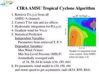
AMSU Intensity and Wind Radii • In general… • derive ~20 parameters from AMSU data • statistically relate them to dependent data (from extended best track) using MLR • develop algorithms to estimate TC intensity (MSW, MSLP) and axisymmetric 34-, 50-, 64-kt wind radii • use axisymmetric wind estimates with modified Rankine vortex model to estimate winds in NE, SE, SW, NW quadrants relative to TC center
Int. & Winds - Data Atlantic 32.1% West Pacific 33.7% Central Pacific 0.2% Southern Hemisphere 7.2% Indian Ocean East Pacific 1.4% 25.4% n > 2600 cases … 5x more than before & 45 cases at Cat-5 level • Data • global dataset for intensity estimation • 1999-2004 for AL, EP; 2002-04 for SH, WP; 2003-04 for CP, IO • for wind radii, used only cases with recon 12 hrs prior 2x as many cases as before… 34: n=255 50: n=170 64: n=120
Int. & Winds - Methods • Added 4 variables to pool • tmax2,clwave2, tmax*clwave, p600 • Using “best subsets” MLR technique • tests all possible models with up to some N number of independent variables…we chose N=15 • Cross-validation • every model tested with 80/20 scheme run 1000 times • Model selection • minimize MAE of developmental and cross-validated datasets • = 0.01 for intensity models, = 0.05 for radii models
Intensity - Results • MSW • NEW: R2=78.7%, MAE=10.8 kt • OLD: R2=76.4%, MAE=11.5 kt • MSLP: • NEW: R2 = 80.2%, MAE = 7.8 hPa • OLD: R2 = 76.4%, MAE = 8.9 hPa
Intensity Results – Ivan Example Hurricane Ivan Example (n=25) New MAE = 15.4 kt New RMSE = 18.0 kt Old MAE = 18.7 kt Old RMSE = 21.3 kt
AMSU 2-D Surface Winds • Quick summary… • use nonlinear balance equation (Charney, 1955) to estimate 3-D wind field from AMSU data • compare AMSU-derived nonlinear balance winds at 850 hPa with QuikSCAT and H*Wind surface wind analyses • AMSU wind speeds at 850 hPa linearly related to surface wind speeds • characteristic biases of wind direction between AMSU and Quik SCAT or H*Wind • develop algorithm to convert 850 hPa to surface winds
IR Wind Structure • Quick summary… • Use IR data to develop algorithms that estimate RMAX and V182 via MLR • Use these estimates with modified Rankine vortex model to estimate symmetric tangential wind profile • Add storm motion-derived wind asymmetry to reconstruct entire 2-D wind field
Sources of More Info • Demuth et al. 2004 (JAM) • Demuth et al. (follow-up note submitted to JAM) • Bessho et al. (submitted to JAM) • Mueller et al. (submitted to Wea. Forecasting)