Download
1 / 25
250 likes | 459 Vues
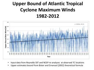
Near-real time monitoring of the upper ocean from altimetry for tropical cyclone studies www.aoml.noaa.gov/phod/cyclone/data. Gustavo Jorge Goni Gustavo.Goni@noaa.gov. United States Department of Commerce National Oceanic and Atmospheric Administration

E N D
Near-real time monitoring of the upper ocean from altimetry for tropical cyclone studies www.aoml.noaa.gov/phod/cyclone/data Gustavo Jorge Goni Gustavo.Goni@noaa.gov United States Department of Commerce National Oceanic and Atmospheric Administration Atlantic Oceanographic and Meteorological Laboratory Miami, Florida, USA. NOAA Climate Observation Program Third Annual System Review Washington, DC, April, 2005 FINAL
From SDSU web page Regions of tropical cyclones
Courtesy of NOAA/NHC Track and intensity forecast
Tropical Cyclone Heat Potential Objective Investigate if a detailed description of the upper ocean thermal structure can be used to identify regions of very high thermal energy that, in turn, could contribute to the (sudden) intensification of tropical cyclones.
Wang, 2004 The upper ocean and tropical cyclones Hurricane force winds Adapted from DeMaria and Kaplan 26oC
Two layer reduced gravity approximation Why not JUST use SSTs ?
Courtesy R. Lumpkin current proposed Validation of altimetry estimates of THCP fields: PIRATA array
Validation of altimetry estimates of TCHP fields: XBT transects
dif = -3m rms dif= 15m Deficiency of the Observing system…. dif = -2 KJ/cm2 rms dif= 15 KJ/cm2 Comparison of altimeter-derived TCHP fields with actual observations September 24, 2004
Deficiency of the Observing system…. Comparison of altimeter-derived TCHP fields with actual observations
Tropical Cyclone Heat Potential and hurricane Intensification: KEY RESULTS Approximately 30 out of 40 rapid intensifications in the TA during 1993-2001 can be linked to the ocean, where the intensification occurs when the path of the TC goes over regions with deepening (>20m) of H26 and increasing (>20 kJ/cm2) TCHP values. The ocean thermal structure appears to be linked to tropical cyclone intensification when the cyclone is more intense.
Courtesy NOAA/NESDIS The upper ocean and tropical cyclones Altimeter-derived TCHP is now one of the 16 intensity predictors in SHIPS of tropical cyclone intensification in the TA
Hurricane Ivan: TCHP* fields in SHIPS Frances Ivan Altimeter-derived TCHP as one of the 16 intensity predictors during Ivan Courtesy NOAA/NESDIS * TCHP fields generated at NOAA/NHC
Sea surface temperature (Frances & Ivan, 2004) ΔSST (Frances) ~ -1 to -8C ΔSST (Ivan) ~ -1 to -5C
Tropical Cyclone Heat Potential (Frances & Ivan, 2004) ΔTCHP (Frances) ~ -10 to -80kJ/cm2 ΔTCHP (Ivan) ~ 0 to -80kJ/cm2
Global estimates of Tropical Cyclone Heat Potential http://www.aoml.noaa.gov/phod/cyclone/data
Global fields of TCHP September 20, 2004
Typhoon Nida (2004) and TCHP Taiwan Philippines Intensification
Daily TCHP fields Continue comparison and validation Improve access of data Current work
Transition of science to operations from NASA to NOAA Joint Program: NOAA/AOML, NOAA/NESDIS, NRL-JWTC: Evaluate NOAA/AOML, TPC, and NRL MODAS TCHP fields using real-time estimates from the observing system. Provide NOAA/NESDIS with the best TCHP fields to incorporate into NESDIS-SHIPS and JTWC-STIPS to improve hurricane intensity forecast.
Recommendations Improve ocean observing system in the Caribbean and Gulf of Mexico, to obtain surface, subsurface thermal data in real-time Support the availability of AT LEAST TWO satellite altimeters, which will provide crucial data for tropical cyclone studies.
END Email: Gustavo.Goni@noaa.gov www.aoml.noaa.gov/phod/cyclone/data
END Email: Gustavo.Goni@noaa.gov www.aoml.noaa.gov/phod/cyclone/data