NGS Organizational Evolution for Geospatial Advancement
Learn about NGS's strategic plan, staffing changes, and customer-focused approach for a modernized geospatial infrastructure.

NGS Organizational Evolution for Geospatial Advancement
E N D
Presentation Transcript
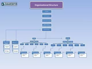
NGS Organizational Structure December 3, 2008 David Zilkoski, Director NOAA’s National Geodetic Survey
NGS Staffing • Significant decline in FTES in past 12 years, and prior • Targeted hiring to fill programmatic gaps identified in 10 year plan
Levels of Planning at NGS Customers’ Needs NGS Mission Customer Review and Validation Ten Year Plan What we aspire to do and the results we anticipate. Strategic Plan (out to 5 years) What we will focus on together each year and who is accountable to deliver tangible results. Annual Operating Plan Projects Activities Budget The level of specificity and detail increases with each level of plan.
Modernize the 3-D Geometric Reference System* Evolve Infrastructure HOW WE ARE GOING TO GET THERE Evolve Infrastructure Cultural Change Increase Agency Visibility Modernize the Geopotential (“Vertical”) Datum Customer Focused Outcome Driven Expand Models & Tools Integrated and Collaborative Organization Evolve Core Capabilities Migrate the Coastal Mapping Program Build Outside Capacity
What Have We Been Doing for the Last 10 Years? PSC We’ve been putting the pieces together and building on past efforts for over a decade Convocations and Leadership Summits Workforce Management Team Workforce/ Outsourcing Plan NGS Decision Making Structure ESC Geodesy What Lies Ahead Succession Planning Leadership Development Efforts One Piece Missing! NGS Decision Making Model Strategic Plan Annual Guidance Document Annual Operating Plan NGS 10 Year Plan Branch and Division Chiefs Groups Customer Focused Integrated and Collaborative Organization Cultural Change =
Some Outcomes On Which We Need to Focus • Coastal Inundation • Droughts • Earthquakes • Floods • Human & Ecosystem Health • Hurricanes • Landslide and Debris Flow • Tornados • Tsunamis • Volcanoes • Heat Waves • Technological Disasters • Wild Fires • Winter Storms
Emergency Managers Planners and Developers Insurance Industry Agricultural Industry Construction Industry Environmental Engineers Coastal Managers Local governments Tribal governments International Organizations Academia Professional Organizations Private Sector Foreign Counterparts Some Customers We Need to Listen to and Work With
How do we getstakeholder input? • ACSM AAGS Government Program Committee • ESRI NGS Special Interest Meeting • National Association of Counties • National Association of County Surveyors County Scorecard web survey • National Association of County Engineers County Scorecard web survey planned for FY09 • Web Requests for Input • Strategic Plan • Suggestion Box Button • ForeSee Pop Ups • NGS Products and Services Committee • Requires Customer Input before finalizing new products and services • Geomatics Industry Assn. of America/ American Congress on Surveying and Mapping/NGS Joint Meeting
It is not enough to just provide the infrastructure, models and tools. We need to listen to our customers to derive the appropriate models and tools. We then need to work with our customers to build outside capacity so we can accomplish the desired outcome together.
Meeting Future Needs Requires CULTURAL CHANGE Evolve YOUR Infrastructure to Decrease Resources Required to Maintain and Operate Professional Standards & Practice Professional Education Spatial Information Management Construction Economics and Management Enhance Models and Tools for YOURSELF and OTHERS Hydrography Spatial Planning & Development Build Outside Capacity so OTHERS use YOUR Infrastructure, Models and Tools. Positioning and Measurement Valuation and the Management of Real Estate Engineering Surveys Cadastre & Land Management
How Can We Make This Happen? • Help shape geospatial policy by creating national and international policy together • Work together with other disciplines to achieve agreed upon outcomes • Retrain workforce from being the “doers” to being the teachers and trainers • Set goals and actions that require collaboration with other organizations to achieve a common outcome • Develop cross-discipline activities that will achieve agreed upon outcomes • Develop mechanisms for cost-sharing and leveraging funds