CLIMATE
CLIMATE. Social Studies Core-9. February 18, 2013. World Culture Regions Check World Climate Regions What creates climate? Factors contributing to climate regions. Climate Regions. Tropical Wet – Located along the equator; receive 100+ inches of rain per year


CLIMATE
E N D
Presentation Transcript
CLIMATE Social Studies Core-9
February 18, 2013 • World Culture Regions Check • World Climate Regions • What creates climate? Factors contributing to climate regions.
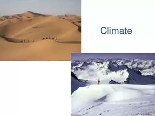
Climate Regions • Tropical Wet – Located along the equator; receive 100+ inches of rain per year • Tropical Wet & Dry – Located along the equator on outer edges of Tropical Wet regions. 2 seasons: Summer (wet); Winter (dry)
Semi-Arid – transition between wet and dry regions. Sometimes rain. Long droughts. • Desert (Arid) – Located along 30 degree latitude lines. Cold water currents force dry air over land OR on the land side of mountains
Mediterranean – located between 30 and 45 degrees latitude. WEST side of continents. Mild weather (no extremes) due to ocean currents. • Marine West Coast – located west-coast, mid-latitude. Influenced by the presence of mountains.
Humid Subtropical – located on EAST coasts between 20 and 30 degrees latitude. Minimal temperature change. • Humid Continental – located in interior of continents between 40 and 60 degrees lat. 4 seasons, drastic temperature changes. 20-50” precipitation.
Subarctic – located in interior at high altitudes. Long extremely cold winter, short cool summer • Tundra – Located along the Arctic Ocean. Some places never thaw.
Ice Cap – Located near the poles. • Highlands – usually found in mountain areas or plateaus. Temp depends on elevation –warm to cold.
What is climate? • Write your definition in the space on your sheet.
What is climate? • What climate is not: WEATHER • Day-to-day temperature and precipitation • What climate is: • temperature and precipitation “averaged” over time
What affects climate? L W O T atitude inds (prevailing ceans opography
Latitude • Reason #1: the further you get from the equator, the _________ it gets. High Latitudes: ___ to ___ Mid Latitudes Low Latitudes: ___ to ___ Mid Latitudes: ___ to ___ High Latitudes
Latitude • Reason #2: How far you are from the equator affects the direction of the prevailing wind • NOT the jet-stream! • NOT the daily winds! • PREVAILING winds • From which direction does our weather come?
Winds (prevailing) 60o Tropic of Cancer Westerlies (prevailing) 30o Easterlies Equator 30o Tropic of Capricorn Westerlies (prevailing) 60o
Oceans • Which changes temp faster? • Water or land/rock? • Currents • “Rivers” of the ocean 1000’s of miles
Topography 4. precipitation falls 5. Air falls 3. Air can’t hold water 6. Air heats 2. Air cools 1. Air forced up 7. Air “dries”
Himalayan Mountains Question: Which direction is north? Question: Which direction does the wind blow? Question: Why the difference in land cover? N Wind
Weather Check 60o 30o If this were a mountain range, on which side would it rain? Side A or Side B? Equator 30o A B 60o
Factors that affect/change climates Latitude Winds YES / NO Oceans Topography YES / NO
World Climate Regions • Why do so many climate bands go west to east? • Where do you see the effects of the ocean?
COLDCLIMATES TEMPERATECLIMATES DRYCLIMATES HOTCLIMATES
CLIMATE Social Studies Core-9
February 19, 2013 • Agenda • Achieves • LWOT (TOWL) • Climographs • Review
Climographs(2 graphs in 1!) What are the 3 axis on this graph? Temperature Precipitation Months Which axis is independent? Months (Bottom) Which element of the graph represents precipitation? Bars Which element of the graph represents temperature? Line What is the range of units for precipitation? 0-5 feet 70o How much precipitation occurs in October? 2.1” How hot is it in May?
San Francisco, CA How would you describe the pattern of precipitation over the year? How would you describe the temperature pattern throughout the year? Reykjavik, Iceland 1. What are the similarities between these graphs? 2. Are these the same climates?
A fun little quiz for you…. guess where each picture is from. For each of the following pictures, guess if it is San Francisco or Iceland.
b d a c
e f g
h j i
b San Francisco d San Francisco a Iceland Iceland
e f g All are San Francisco
h j i All are Iceland!!!!