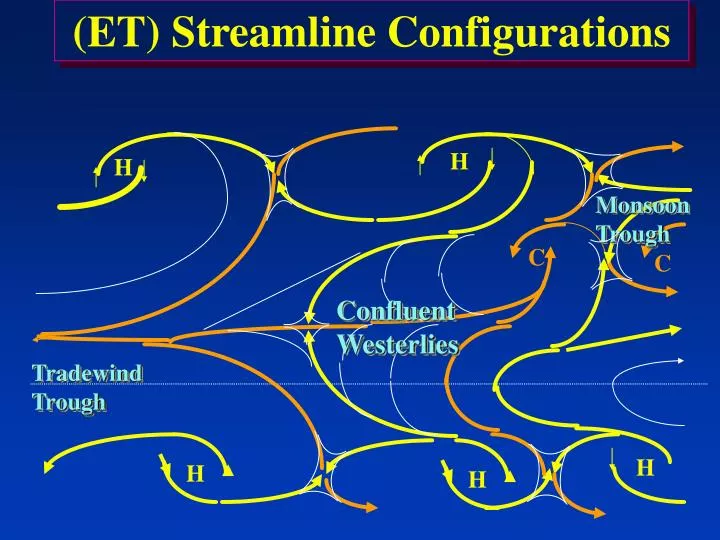

(ET) Streamline Configurations
E N D
Presentation Transcript
H H (ET) Streamline Configurations H H Monsoon Trough C C Confluent Westerlies Tradewind Trough H
H H (ET) Streamline Configurations H H Monsoon Trough C C Confluent Westerlies Tradewind Trough H
Diurnal Effects • Temperature Range • Clouds • Rainfall
Diurnal Effects • Temperature Range • On small islands and coastlines 3-5°C with prevailing onshore flow. • On inland locations or coasts 5-10°C with prevailing land breeze. • In the interior in the dry season > 10°C.
Diurnal Effects • Clouds • Oceans • Maximum (0400-0700L), minimum (1400L-1900L) • Land • Daytime maximum, nocturnal minimum
Diurnal Effects • Rainfall • Nocturnal max over oceans, and small islands. • Shower maximum over land in afternoon. • Monsoon areas and areas in disturbances have night to early morning maximum.
Tertiary Circulations • Land and sea breezes • Sea-breeze characteristics. • Sets up a few hours after sunrise. • Moves inland until late afternoon to evening. • Strong breezes may extend 30 - 50 miles inland. • Land-breeze characteristics. • Generally shallower with weaker winds than sea breeze. • Normally does not penetrate as far offshore as sea breeze penetrates onshore. • Land breeze front often triggers convection, especially converging land breezes
Rainfall - Special Cases Prevailing flow onshore: Prevailing flow offshore Daytime max on inland slopes Afternoon max on coastline Day Sea Breeze Nighttime max on coastline Night Land Breeze
Tertiary Circulations • Orographically-induced winds. • Valley breeze. • Slopes warm during day. • Upslope wind. • Clouds and convection over peaks during daytime. • Mountain breeze. • Slopes cool at night. • Downslope wind. • Clouds and convection in valleys at night.
Tertiary Circulations • Orographically-induced winds. • Mountain gap winds. • Funneling through passes when surface gradient across mountains is strong. • Example: Tehuantepecer winds off Mexico.
Upper-Tropospheric Features • Tropical Upper-Tropospheric Trough (TUTT) • Forms in summer hemisphere over mid-oceans. • Subtropical ridge - part that moves poleward over land masses (North America, eastern Asia). • Subequatorial ridge - part that stays near equator over the ET.
Upper-Tropospheric Features • Tropical Upper-Tropospheric Trough (TUTT) - Continued - • Level: Most intense - 200 mb. • Orientation: ENE-WSW • Season: Late April - Mid November (most intense in August
Upper-Tropospheric Features • Tropical Upper-Tropospheric Trough (TUTT) - Continued - • Position: South of Surface Subtropical Ridge over trade winds (convergent weather associated with TUTT occurs in tradewinds) • Major Convergent Weather: Few degrees southeast of upper level center • Weather in axis or Cyclonic Cell Center: Few clouds, general sinking motion
Upper-Tropospheric Features • Tropical Upper-Tropospheric Trough (TUTT) - Continued - • Temperature: Cold trough (3-5 degrees colder than environment, Isold TCU and TSTMs in TUTT, and center of cells • Axis Windshift: Often an abrupt 180 degree turn at trough axis • Cirrus Tracers: Indicates > 50 kts either side of TUTT or embedded cell.
Overview • Upper-Tropospheric cyclones (cold lows). • Strongest 200 to 300 mb and weaken downward. • TUTT cells are most common examples. • Center • Usually clear due to subsidence, though deep cold cells can have some core convection. • Periphery • Upper-level divergence, mostly SE side. • Satellite Imagery • Ring of clouds about 140 nm from center. • Dark round area on water vapor image (best seen in water vapor!).
TUTT cell <------TUTT cell
TUTT Cell -----------> in Multispectral Imagery
NOGAPS 200 mb temperatures <-----Trough
Non-severe Weather Systems and Tertiary Circulations • Lines • Tropical Waves • Vortices • Land and Sea Breezes • Valley and Mountain Breezes
Non-severe Lines • Lines - synoptic scale convergence with length much greater than width. • Squall lines • Cold fronts • Shear lines • Surge Lines • Near Equatorial Convergence Zones
Non-Severe Tropical Waves • National Hurricane Center (NHC) definition - a trough or cyclonic curvature maximum in the trade-wind easterlies. • Sometimes called “Tropical Easterly Waves” in the Atlantic. • Originally, this term was based on older research on the tropics that was based on sparse surface and upper air data.
Non-Severe Tropical Waves • When NHC started using METSAT imagery in 1967, they saw new aspects of the so-called “wave” that didn’t fit the theoretical model. • Not as common as previously thought; many systems called waves were actually vortices • This model is falling out of favor with many in the tropical community.
The “Tropical Easterly Wave”
Non-Severe Tropical Waves • Characteristics • Many stem from upper-level cyclones (cold lows). • Characteristics of Atlantic (easterly) waves. • Form over Ethiopian Highlands June to October. • Move across baroclinic zone south of Sahara - often form squall lines. • Dampen under STR axis in eastern Atlantic and strengthen near Lesser Antilles.
Non-Severe Vortices • Fair weather vortices - (Equatorial anticyclone, heat low, and TUTT)… • Bad weather vortices - (Tropical cyclones, monsoon depression, west African cyclones, and mid Tropospheric cyclones).
Fair Weather Vortices • Equatorial anticyclones • Found where monsoon trough is more than 10° from equator • Surge from opposite hemisphere crosses equator and turns anticyclonically • Curved band of cloud seen at leading edge of anticyclone
Fair Weather Vortices • Heat lows/ heat troughs • Low-level air rises over hot land with subsidence aloft. • Lowest pressure coincides with highest temperature. • Examples • Sahara and SW Asia in summer (may be part of monsoon trough). • Southern South America, southern and eastern Africa all year.
Bad Weather Vortices • Mid-tropospheric cyclones. • Subtropical cyclones. • Cut-off portion of deep mid-latitude trough in the tropics in winter. • Example: "Kona" storms in Hawaii, cause SW winds and heavy rains. • Arabian Sea cyclones • Major rainmaker on west coast of India in SW monsoon. • Cloud pattern resembles a typhoon.
The Central American Monsoons • Regional Effects • Region normally dominated by NE trade winds. • Channeling causes 3 quasi stationary cyclones on Pacific side of Central America which anchor monsoon trough. • Northern Hemisphere easterlies to north and Southern Hemisphere westerlies to south maintain cyclones.
The Central American Monsoons • Panama Bay cyclone • Strongest anchoring cyclone of the three. • Reinforced by warm ocean currents. • Southwesterly flow channeled cyclonically by Andes year-round. • Persistent feature May through January.
The Central American Monsoons • Lake Nicaragua cyclone • Anchored between Nicaragua and Costa Rica. • Weaker than Panama bay cyclone, persists May - November. • Gulf of Tehuantepec (Guatemalan) cyclone. • Weakest of the three. • Maximum strength in October • Merges with NECZ to west, which is anchored over SST thermal maximum.
The Central American Monsoons • American Monsoons don't meet Ramage's Criteria because • Semi-annually reversing North-South pressure gradients do not form. • Instead, Central America has a "transitional" monsoon. • Oscillates north - south semiannually. • Location determined by strengths of NE trades and Southern Hemisphere southwesterlies.
The Central American Monsoons • Monsoon Surges • Often caused by low-latitude (10 - 20°N) tropical cyclones. • Acceleration of southwesterlies from south of monsoon trough. • NE flow aloft back into Southern Hemisphere.