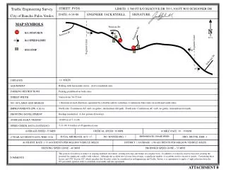
Download
1 / 1
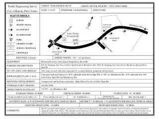
10 likes | 96 Vues
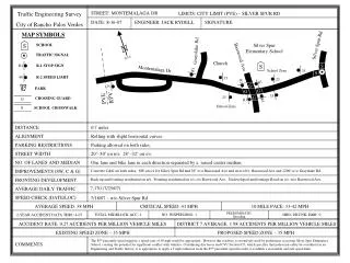
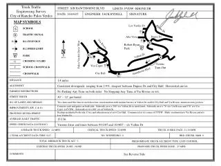
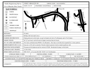
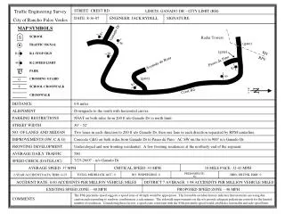
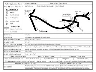
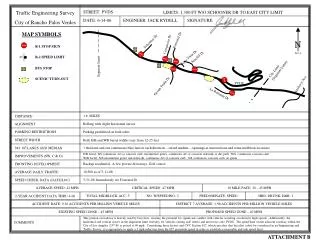
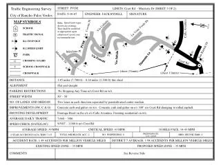
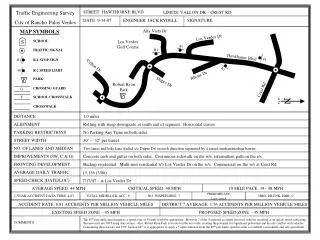
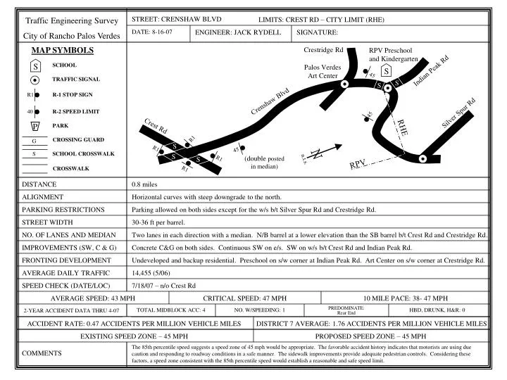
S. S. N. n.t.s. R1. R1. 45. 40. 45. S. G. R1. STREET: CRENSHAW BLVD. Traffic Engineering Survey City of Rancho Palos Verdes. LIMITS: CREST RD – CITY LIMIT (RHE). DATE: 8-16-07. ENGINEER: JACK RYDELL. SIGNATURE:. MAP SYMBOLS. Crestridge Rd. RPV Preschool and Kindergarten.

E N D
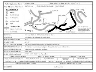
S S N n.t.s. R1 R1 45 40 45 S G R1 STREET: CRENSHAW BLVD Traffic Engineering Survey City of Rancho Palos Verdes LIMITS: CREST RD – CITY LIMIT (RHE) DATE: 8-16-07 ENGINEER: JACK RYDELL SIGNATURE: MAP SYMBOLS Crestridge Rd RPV Preschool and Kindergarten SCHOOL Palos Verdes Art Center Indian Peak Rd TRAFFIC SIGNAL S S R-1 STOP SIGN Crenshaw Blvd R-2 SPEED LIMIT Silver Spur Rd 45 Crest Rd PARK RHE P R1 CROSSING GUARD S SCHOOL CROSSWALK S (double posted in median) S RPV CROSSWALK R1 DISTANCE 0.8 miles ALIGNMENT Horizontal curves with steep downgrade to the north. PARKING RESTRICTIONS Parking allowed on both sides except for the w/s b/t Silver Spur Rd and Crestridge Rd. STREET WIDTH 30-36 ft per barrel. NO. OF LANES AND MEDIAN Two lanes in each direction with a median. N/B barrel at a lower elevation than the SB barrel b/t Crest Rd and Crestridge Rd. IMPROVEMENTS (SW, C & G) Concrete C&G on both sides. Continuous SW on e/s. SW on w/s b/t Crest Rd and Indian Peak Rd. FRONTING DEVELOPMENT Undeveloped and backup residential. Preschool on s/w corner at Indian Peak Rd. Art Center on s/w corner at Crestridge Rd. AVERAGE DAILY TRAFFIC 14,455 (5/06) SPEED CHECK (DATE/LOC) 7/18/07 – n/o Crest Rd AVERAGE SPEED: 43 MPH CRITICAL SPEED: 47 MPH 10 MILE PACE: 38- 47 MPH TOTAL MIDBLOCK ACC: 4 NO. W/SPEEDING: 1 PREDOMINATE: Rear End HBD, DRUNK, H&R: 0 2-YEAR ACCIDENT DATA THRU 4-07 ACCIDENT RATE: 0.47 ACCIDENTS PER MILLION VEHICLE MILES DISTRICT 7 AVERAGE: 1.76 ACCIDENTS PER MILLION VEHICLE MILES EXISTING SPEED ZONE – 45 MPH PROPOSED SPEED ZONE – 45 MPH The 85th percentile speed suggests a speed zone of 45 mph would be appropriate. The favorable accident history indicates that motorists are using due caution and responding to roadway conditions in a safe manner. The sidewalk improvements provide adequate pedestrian controls. Considering these factors, a speed zone consistent with the 85th percentile speed would establish a reasonable and safe speed limit. COMMENTS