Download
1 / 20
220 likes | 362 Vues
GIS Overlay. Getting to the “where is?”. Distance 1.... buffering. Creates a distance from a feature Works with points lines and polygons Legal descriptions... Nature rarely pays attention to specified distances... Streams flood by elevation, not distance from the stream

E N D
GIS Overlay Getting to the “where is?”
Distance 1.... buffering • Creates a distance from a feature • Works with points lines and polygons • Legal descriptions... Nature rarely pays attention to specified distances... • Streams flood by elevation, not distance from the stream • Eagles hunt where the food is, not within a ¼ mile circle of their nest • Volcanoes erupt based on internal mechanics influenced by topography, not by neat rings of hazard
Buffer.... • The buffer wizard... • The ArcGIS 8x Buffer wizard • The ArcGIS 8x Buffer Wizard has been removed from the ArcMap Tools menu, but it is still accessible if you click Tools, click Customize, click Tools in the Commands tab, and select Buffer Wizard. If you want to use this wizard, you can add it to any ArcMap toolbar or pulldown menu from the Customize dialog box. You may want to do this to buffer graphics drawn on a map. • NOTE: In the Buffer tool, the Side Type option is restricted to FULL and the End Type option is restricted to ROUND if you are using an ArcView or ArcEditor license. Setting the Side Type to LEFT or RIGHT and setting the End Type to FLAT, are only possible if you are using ArcInfo.
This is the interface developed in Arcview 3.X Allows you to buffer only the selected features
The buffer tools.... You cannot buffer selected features (unless you select features and convert them to a new data layer (shapefile)
Spatial Join • Uses the ‘shape’ field to join two spatial attribute layers • Works with points/lines or polygons (Raster data requires another approach) • From the Joins and relates tab
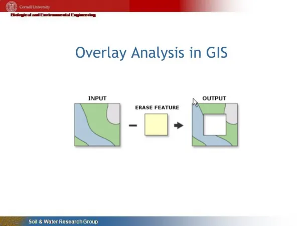
Overlay tools • Clip- the cookie cutter • Erase-the eraser shield • Intersect-keeps data from both data sets • Union- keeps everything from every data set • Dissolve- remove internal lines based on an attribute (censuses tracts inside a county) • Merge-add two spatial data sets together (tiger files from Lauderdale and Colbert counties)
The ArcGIS 8x Geoprocessing Wizard has been removed from ArcMap; it is no longer provided in the product. • Locating the 8x Geoprocessing Wizard operations in the ArcToolbox window • Clip— Analysis toolbox > Extract toolset > Clip tool • Intersect— Analysis toolbox > Overlay toolset > Intersect tool • Union— Analysis toolbox > Overlay toolset > Union tool • Dissolve— Data Management Tools toolbox > Generalization toolset > Dissolve tool • Merge— Data Management Tools toolbox > General toolset > Append tool • NOTE: In the Union and Intersect tools, only two inputs are allowed if you are using an ArcView or ArcEditor license. The ability to union or intersect more than two inputs is only available if you are using an ArcInfo license.
X-Tools The better way to spatial analysis in Arcview 3.X