Understanding Atmospheric Processes: Evaporation, Convection, and Thunderstorm Dynamics
This article explores various atmospheric processes, including evaporation from the Earth's surface, condensation in clouds, and the dynamics of thunderstorms. It highlights the significance of thermodynamic principles like the first and second laws, addressing concepts such as adiabatic processes and the conditions required for convection. Additionally, it compares air mass thunderstorms to squall lines, emphasizing the self-destroying nature of the former and the destructive potential of the latter. The interaction of humidity, temperature, and pressure plays a crucial role in these meteorological phenomena.

Understanding Atmospheric Processes: Evaporation, Convection, and Thunderstorm Dynamics
E N D
Presentation Transcript
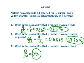
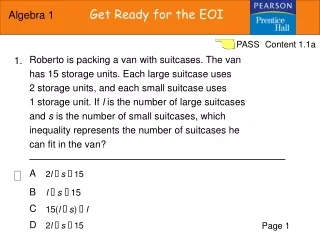
(C, B, A, C, D, D, B, A) x x x x x
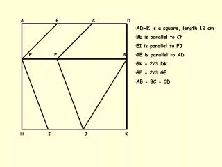
x x x CISK & air/sea interaction Evaporation from the earth’s Surface Condensation in clouds and precipitation Photochemical reaction at 20-60km Reaction with plants at the surface and dissolution in water Mixing due to fluid motion and molecular diffusion Mixing due to fluid motion downward decreases increases geostrophic right ITCZ pa=Rd T pa=Rd Tv CCN
Collision and coallescence Riming and aggregation Coriolis force vanishes on the equator, and hurricane growth needs the Coriolis force Physically, it means that the upward pressure gradient force is Balanced by the downward gravitational force. The first law of thermodynamics is: dq=du+dw: heat absorbed by a system is used to increase its internal Energy (du) and do external work (dw). For adiabatic processes, Dq=0. So, du=-dw. When an air mass comes down a big mountain, it experiences adiabatic compression because pressure increases toward the earth’s surface. Compression reduces its volume and thus dw=pda<0, and du=-dw>0. Internation energy increae indicates temperature increase. This is why we often observe warm air at foothills. The entropy is higher in the case with precipitation. This is because when there isn’t precipitation, The process is adiabatic and reversible, wherease with precipitation the process is Pseudoadiabatic and irreversible. For irreversible process, its entropy increases. The second law of thermodynamics says The = sign hlods for reversible and > sign for irrervisble process. Convection will not occur because the atmosphre is under an absolutely stable stratification.
Yes. Convection will occur if the air parcel is lifted above the level of free convection. This is because the atmosphere is conditionally unstable. Below the level of free convection bouyancy of the air parcel is smaller than its weight (it is heavier than Surrounding iar). Above the level of free convection the air parcel is more buoynant than its surrounding air and thus can go up without external lifting. See figure 1 for level of free convection. We expect convective clouds because of the free Convection. Layered clouds requires stable stratification. It is evident that the two curves coincide well: high (low) nuclei concentration corresponds to high (low) electric field. This is because aerosols are much bigger than electrons, and thus aerosols move much slower than electrons under the same electric fields. The slow motion reduces electrical currents and and thus reduces the neutralization between the positive and negative Charges that generates the electric fields, resulting an increase in the electric field. The major difference between air mass thunderstormand the squall line is that the former has no shear but the latter has a strong shear between their updraft and downdraft winds. In the airmass thunderstorm, precipitation causes downdraft, which cuts off the moisture source provided by the updraft. It has a self-destroying mechanism and thus this type of thunderstorm seldom causes severe damagement. In the squall line, updraft and downdraft winds strengthen each other: the cold downdraft lifts up the warm air and thus increases the updraft; moisture brings up by the updraft condenses and precipitates. Precipitation increases the downdraft by drag effect, and by evaporative cooling which increases density and thus increases the sinking of air. This type of thunderstorm can be very destructive because winds /precipitation are strong due to the self-enhancing mechanism.
Weak disturbances containing vorticity in tropical ocean surface (5-20N(S) latitudes) when SST • is >26.5; for example, a low pressure prturbation; • Geostrophic adjustment (Coriolis force tends to balance pressure gradient force) will generate • a cyclonic circulation; Ekman layer frictional convergence forces the warm air to go up, which • will cause convection, condensation, and thus latent heat release; • Latent heat will increase air temperature and thus further reduce the low pressure perturbation; • Reduced low pressure results in faster rotation and increased frictional convergence, results • in increased convection and latent heat release and even warmer air temperature; • Increased reduction of low pressure.
B D Level of free convection x Height LCL C A Temperature Figure 1
Nuclei Height (km) Electric field Figure 2.