Download
1 / 29
300 likes | 722 Vues
Introduction to Geography People, Places, and Environment, 4e Edward F. Bergman William H. Renwick. Chapter 1: Introduction to Geography Victoria O. Alapo, Instructor Geog 1010. What Is Geography?. Geography is from two Greek words, Geo – Earth, and Graphien – to write.

E N D
Introduction to GeographyPeople, Places, and Environment, 4eEdward F. BergmanWilliam H. Renwick Chapter 1: Introduction to Geography Victoria O. Alapo, Instructor Geog 1010
What Is Geography? • Geography is from two Greek words, Geo – Earth, and Graphien – to write. • It is simply the study of the earth, and everything that goes on, on it. • Geography is the one of the oldest and most diverse fields of study.
Geography Today • Association of American Geographers • www.aag.org • 55 topical specialties (page 5) • Geography asks these questions: Where?, What?, When?, Why?, and Why there? • Spatial analysis – has to do with the distribution of a phenomenon in “space” (this doesn’trefer to outer space). Very Geographical concept.
Geography • Physical – this makes it a natural science. These are the physical xteristics of the envir. • Human & Cultural – these make it a social science. Human groups and our activities. • Cartography – All kinds of mapping. • Geographic Information Systems (GIS) – using computers to help make and display maps and analyze data. A sub-branch of Cartography. • All these fields are interrelated (see table on page 5). That is Assignment #2. Geography is very useful.
History of Geography • Classical Western World • Eratosthenes (276-194 B.C.). This is actually Egypt (Africa), he worked in the library of Alexandria. See pg 3. He believed the world was round. • Hipparchus (180-127 B.C.) – 1st to draw grid lines.
History of Geography • Non-European World • Isaiah (40:22) believed the world was round too! – 700 B.C.! • Al-Edrisi (1099-1154) • Ibn-Battuta (1304-1378) • Ibn-Khaldun (1332-1406) • The Tribute of Yu • Kangnido, see map on pg 4 (read) • Africans traveled a LOT – e.g. Timbuktu (pg 9), Queen of Sheba, Ethiopian Eunuch (Acts 8), East Africa, etc.
“The information that any citizen needs in order to make an informed decision on an important question of the day is largely geographic.”
Regions • A region is an area that shows similar characteristics. • Does not have abrupt boundaries. E.g. climate, culture, etc. It slowly/ gradually goes into the next region.
Spatial Analysis & Movement • Distribution of things. E.g. • Density – the number of phenomena (e.g. people, houses, trees, etc) per sq. mile. • Distance • Measurements • Absolute • Time • Cost • Distance Decay Effect • As distance increases, importance of a particular phenomena decreases • Ex. Newspaper circulation, radio signals, TV reception
Three Types of Diffusion • Diffusion is the spread of ideas, etc. There are 3 main kinds: • Relocation diffusion – e.g. immigration • Contiguous diffusion – e.g. disease • Hierarchical (leapfrog) diffusion – e.g. fashion in cities • Barriers to diffusion • Cultural barriers e.g. political boundaries or differences, cultural differences • Oceans, deserts, distance, time
Interacting spheres L A H B 4 Physical Systems • Atmosphere (air) e.g. Chapter 2 – weather & climate • Lithosphere (Earth’s solid rocks) e.g. Chapter 3 - landforms • Hydrosphere (water) e.g. Chapter 4 - Biogeochemical Cycles • Biosphere (living organisms) e.g. Chapter 4 - Biogeochemical Cycles and the Biosphere
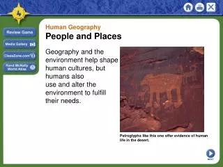
Human-Environmental Interaction • Natural landscapes • One without evidence of human activity. E.g.? • Cultural landscapes • Reveals how humans modify local environment. E.g.? • What about Central Park? Pg 20
The Geographic Grid • Longitude - See Greenwich Photos & next slide • Measures distance east to west around the globe beginning at the Prime Meridian • 2 most important lines of longitude: Prime Meridian & the International Date Line • 0-180 degrees East or West • Latitude • Location on the Earth’s surface between the equator and either the north or south pole • Also called parallels • 0-90 degrees North or South
0 1 2 3 4 Map Making • Called Cartography • Scale • Fraction 1/24,000 • Ratio 1:24,000 • Written statement “1 inch equals 1 mile” • Bar style • Detail and area • Small scale map = less detail, large denominator (1:1,000,000) • Large scale map = more detail, small denominator (1:100,000)
Projection • Scientific method of transferring locations on Earth’s surface to a flat map (“orange peel” concept). See Appendix on pg 591 (Goode’s Interrupted Projection). • 4 types of distortion – see maps on next slide. • Relative size and distance (Mercator). Here, shape is fine, but size is not, esp. at the poles. So the scales are different (see Greenland). Also called “conformal” maps. Pg 26 • Shape and direction (Equal Area projection). These are maps that distort shape but preserve size.
Geographic Information Technology • Automated cartography • Conversion of paper to digital formats • Includes Computer Assisted Drawing (CAD) • Sophisticated, specialized digital cartography systems • Easier, cheaper editing. Manual techniques are expensive and time-consuming, esp. when changes had to be made to maps (e.g. Warren County Courthouse)
Remote Sensing Acquisition of data about Earth’s surface from a satellite orbiting the planet or from high-flying aircraft
Satellites • Landsat • 1972; 1999 • Sensors measure radiation of colors of visible light • Uses: • Weather satellites – for hurricanes, etc. • GPS – uses longitudes & latitudes (pg 33). • More uses are found on next slide.
Uses of Remotely Sensed Data & GIS Spatial Analysis • Human activities (see next slides) • Changes in plant growth • Drainage patterns (rivers) • Monitoring environmental changes with satellite images, e.g. Lake Chad, pg 1 • Counting lakes, pg 36 • Erosion associated with agriculture • Analyzing changes in food production and land use • Logging and forest management • Wetland monitoring • Wartime applications • Calculating densities and distribution of population **GIS means Geographic Information Systems
GIS • Database software for digital information • Contains same information as regular database • Stores spatial characteristics such as boundary information or coordinates and addresses. • Layers • Information with specific characteristics • Soils, hydrology, land ownership, etc. • Can be combined into layers for analysis. Same concept is used for making globes (see next slide).