Managing your Distributed Data
Learn about the benefits of distributing data, geodatabase replication, and the sync engine for offline editing in mobile apps. Understand how to create replica pairs, synchronize edits, and handle schema changes.

Managing your Distributed Data
E N D
Presentation Transcript
Managing your Distributed Data Jim Gough – jgough@esri.com
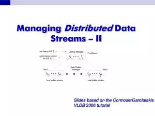
Overview • Why Distribute Data • Geodatabase Replication • Sync Engine (Offline Editing for Mobile Apps)
Why Distribute Data Central hub Contractor Field work National Production GDB Publish to web State Replica tree County
Geodatabase Replication Overview • Distribute dataacross 2 or more geodatabases • creation of a Replica Pair • Geodatabases are edited independently • Loosely coupled • Synchronize edits
Three types of replication PARENT CHILD Sync both directions Two-way Sync one direction One-way Checkout once Checkout/ check-in Check-in once
Demo Replication Two-way One-way Checkout/Checkin
Schema Changes Parent Child 1 Compare schemas 2 Export changes XML 3 Import changes
Disconnected replication Data sender Data receiver 4. Export acknowledgment message andsend to sender 5. Import acknowledgment message XML 1. Edit made to sender GDB XML 2. Data change message exported and sent to receiver 3. Data change message imported to receiver
How does a geodata service work? Web server 443 80 Geodata service ArcSDE GDB
Toggle between all maps and maps saved to your device Cloud with down arrow indicates web map is offline capable Cloud with arrows going up and down indicate map is downloaded to device Cloud with a value in red indicates edits have been made and are available for syncing Webmaps the user has permissions to
Thank you… Please fill out the session survey: Session ID: 742 Use Offering ID : Wednesday 1599 or Thursday 1688 Online – www.esri.com/ucsessionsurveys Paper – pick up and put in drop box Types of Geodatabases Which One is Right for Me?