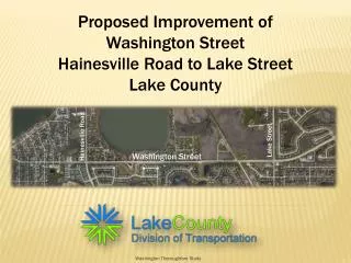
Transforming Washington Street: A Comprehensive Redesign for Community Connectivity and Safety
250 likes | 368 Vues
The Washington Street redesign addresses the historical transformation of the area, once dominated by the Elevated Orange Line until its removal in 1987. The project aims to revitalize the street by incorporating green spaces, enhancing bike connectivity, and promoting safety for all users through well-defined separations. Key elements include integrating traffic calming measures, providing adequate parking, and utilizing design principles from successful international examples. This initiative supports the community's needs while ensuring accessible and safe transport for pedestrians, cyclists, and vehicles alike.

Transforming Washington Street: A Comprehensive Redesign for Community Connectivity and Safety
E N D
Presentation Transcript
The Long Term Solution Washington Street Redesign Andrew Brunn, Kamila Misiak, Sarah Thomas
History of Washington Street • Site of the Elevated Orange Line until 1987 • Viaduct removed in 1987 • Roadway reconstructed • Majority of land has been redeveloped
Design Goals • Provide green space to neighborhood • Traffic calming • Bike connectivity for destinations and through traffic • Safety for all road users through separation • Provide adequate parking
Holland Examples Design Principles Used in Roadway Redesign
Shared Tree/Parking Lane Ruys de Beerenbrouckstraat, Delft, The Netherlands
Additional Green Space Ruys de Beerenbrouckstraat, Delft, The Netherlands
Cars/Pedestrians/Bikes at Different Roadway Elevations Ruys de Beerenbrouckstraat, Delft, The Netherlands
Raised Crossings Ruys de Beerenbrouckstraat, Delft, The Netherlands
Protected Left Turns Ruys de Beerenbrouckstraat at Provincialeweg, Delft, The Netherlands
Roadway Redesign Typical Sections and Plan Views
Existing Cross Section 10’ Sidewalk 20’ Travel Lane/Parking 20’ Travel Lane/Parking 10’ Sidewalk
Typical Proposed Cross Section 11’ Travel Lane 6’ Green Space 5’ Cycle Track 6’ Sidewalk 8’ Parking in Tree Lane 11’ Travel Lane 5’ Cycle Track 6’ Sidewalk 2’ Buffer
Inline Bus Stops Cycle track crossing behind bus stop
Inline Bus Stops - West side 6’ Sidewalk 5’ Cycle Track 6’ Bus Platform 11’ Travel Lane Plus 2’ Buffer 11’ Travel Lane 6’ Green space 5’ Cycle Track 6’ Sidewalk Cycle track crossing behind bus stop
Inline Bus Stops - East side 2’ 6’ Sidewalk 6’ Sidewalk 5’ Cycle Track 5’ Cycle Track 11’ Travel Lane Plus Buffer 11’ Travel Lane Plus Buffer 11’ Travel Lane Plus Buffer 11’ Travel Lane Plus Buffer 6’ Bus Platform 6’ Bus Platform 5’ Cycle Track 5’ Cycle Track 6’ Sidewalk 6’ Sidewalk Buffer Cycle track crossing behind bus stop
Signalized Intersections Add left turn arrow at signalized intersections
Connectivity with Shelburne Community Center Two way cycle track within park
Connectivity with Shelburne Community Center 7’ Sidewalk 5’ Cycle Track 11’ Travel Lane 11’ Travel Lane 9’ Green Space 8’ Two Way Cycle Track 7’ Sidewalk 2’ Buffer Two-way cycle track to provide safe access
Activating Washington Park 7’ Sidewalk 5’ 2’ 11’ Travel Lane 11’ Travel Lane 22’ Green Space 12’ Two Way Cycle Track 6’ Side walk 22’ Green Space Cycle Track Buffer Two Way Cycle Track with Sidewalk within park