1 / 36

北北印 Northern of INDIA

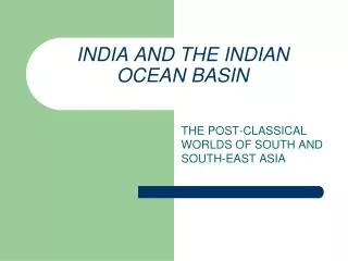
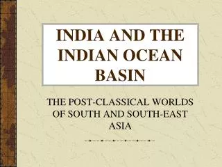
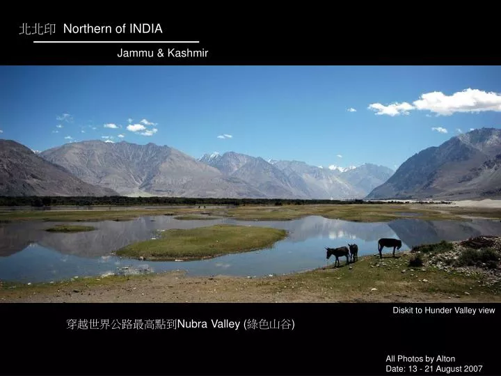
北北印 Northern of INDIA. Jammu & Kashmir. Diskit to Hunder Valley view. 穿越世界公路最高點到 Nubra Valley ( 綠色山谷 ). All Photos by Alton Date: 13 - 21 August 2007. Thiksey Gompa Sunset time. Thiksey Gompa buildings. Thiksey Gompa Roof – Young Monks. Thiksey Gompa – Monks.

hong
Télécharger la présentation

北北印 Northern of INDIA

An Image/Link below is provided (as is) to download presentation Download Policy: Content on the Website is provided to you AS IS for your information and personal use and may not be sold / licensed / shared on other websites without getting consent from its author. Content is provided to you AS IS for your information and personal use only. Download presentation by click this link. While downloading, if for some reason you are not able to download a presentation, the publisher may have deleted the file from their server. During download, if you can't get a presentation, the file might be deleted by the publisher.

E N D

Presentation Transcript


  1. 北北印 Northern of INDIA Jammu & Kashmir Diskit to Hunder Valley view 穿越世界公路最高點到Nubra Valley (綠色山谷) All Photos by Alton Date: 13 - 21 August 2007

  2. Thiksey Gompa Sunset time

  3. Thiksey Gompa buildings

  4. Thiksey Gompa Roof – Young Monks

  5. Thiksey Gompa – Monks

  6. Thiksey Gompa - Morning class prayer time – Young Monks

  7. Thiksey Gompa - Morning class prayer time – Young Monks

  8. Thiksey Gompa - Buildings

  9. Thiksey Gompa – The gompa buildings on the mountain

  10. Khardung La – The highest motorable pass in the world. Elevation 5602m 清晨六點的日出,在世界公路海拔最高點Khardung La

  11. Leh to Manali Hwy view

  12. Nubra Valley – Diskit Gompa

  13. Nubra Valley – Diskit to Hunder village

  14. Nubra Valley – Diskit to Hunder - Marsh

  15. Nubra Valley – Diskit to Hunder – Desert 沙漠

  16. Nubra Valley – Diskit to Hunder – Small river

  17. Nubra Valley – Diskit to Hunder - Goats

  18. Thiksey Gompa – The local buildings

  19. Nubra Valley – Diskit to Hunder – The tents reflected in the lake.

  20. Nubra Valley – Diskit to Hunder – The landscape of lakes and mountains.

  21. Nubra Valley – Diskit to Hunder – Rinsing man and lazy donkey

  22. Nubra Valley – Diskit to Hunder – Camels

  23. Nubra Valley – Diskit to Hunder – Riding Camel

  24. Nubra Valley – Diskit to Hunder – Donkeys 驢子三兄弟

  25. Leh to Manali Hwy – Taglang La – The second highest motorable pass in the world. Elevation 5328m

  26. Leh to Manali Hwy – Enjoy the pleasant sensation of overtaking in Valley. 飆車在沙石路的山谷路間

  27. Leh to Manali Hwy – Narrow winding trail. 行駛在羊腸小道的山間道路上

  28. Leh to Manali Hwy – The rest station 半路的休息站

  29. Leh to Manali Hwy – Narrow winding trail. 行駛在羊腸小道的山間道路上

  30. Leh to Manali Hwy – Carrying

  31. Leh to Manali Hwy – Valley

  32. Leh to Manali Hwy – Waterfall

  33. Leh to Manali Hwy – Village of Valley

  34. Leh to Manali Hwy – building the road

  35. Nubra Valley Hunder Village – Prayer flags and Sun flowers with blue sky -- The End --

  36. 在Nubra Valley 待了約一個禮拜,其實是被困在裡面的,因為找不到交通工具離開這裡。但卻意外發現Diskit 到 Hunder村落這七公里的美麗風景,在旅行時常有意外驚喜,也是我熱愛旅行的原因之一。 為了拍藏廟眾喇嘛唸經畫面,特地前一天住在當地民宿並五點半起床準備,本來六點開始的每日早課,那一天卻延遲到七點,害我這麼早起,但美麗的日出是給我的獎賞。 若你想看壯闊的山谷平原、沼澤地、沙漠和特殊的印式建築,請來到Nubra Valley. Yi-Fan 逸帆 Restricted until 1988, this rugged 470km road - the 2nd highest in the world - is only open about three months per year. It goes over three massive passes, the highest, Taglangla, at 5330 metres (over 17,000 feet). It's a tough barely-a-road-drive, but absolutely gorgeous. All Photos by Alton Mail: alton4952@gmail.comMore Photos: http://album.blog.webs-tv.net/altonzhang

More Related