National Ecological Observatory Network
350 likes | 588 Vues
National Ecological Observatory Network. Dave Tazik & NEON Team Toolik Field Station Vision Workshop Portland, OR 2-4 August 2012. A Continental Observation System. A CONTINENTAL-SCALE OBSERVATION SYSTEM. 30 year period of observation. NEON Mission. Causes of Change Climate Land Use

National Ecological Observatory Network
E N D
Presentation Transcript
National Ecological Observatory Network Dave Tazik & NEON Team Toolik Field Station Vision Workshop Portland, OR 2-4 August 2012
A Continental Observation System A CONTINENTAL-SCALE OBSERVATION SYSTEM 30 year period of observation
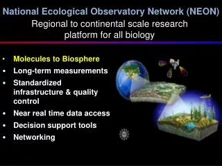
NEON Mission Causes of Change Climate Land Use Invasive Species Response to Change Biodiversity Biogeochemistry Ecohydrology Infectious Disease … to enableunderstanding and forecasting of the impacts of climate change, land use change and invasive species on continental-scaleecology …by providing infrastructure to support research, education and environmental management in these areas
A User Facility and Community Asset An Integrated Observing System A 30 year period of Observation Individual Team REMOTE SAMPLING NAT. DATA SETS Community Managers & Policy--makers ONSITE SAMPLING DATA PRODUCTS
Observing Ecological Change • Representative sampling • Replication of gradients • Detecting/attributing change over decades • Standardized and transparent protocols • Comprehensive set of observations • Terrestrial and aquatic • Sentinel taxa • Field and lab analyses state-of-the-art • QA/QC -- data quality and uncertainty Free and open access to all NEON data* * Unless legislatively protected
NEON Data Products ~ 1600 Level 0 data products (primary observations) • Raw voltages from sensors • Information on collected flora/fauna(e.g. counts) • External DNA or chemical analysis • Raw LiDAR returns ~ 540 Level 1 data (QA/C, minimally processed) • One-minute average air temperature • Site-level species composition • GeorectifiedLiDAR ~ 75 Level 2 (rectified) & Level 3 (common gridded) • Gap-filled one-minute air temp (L2) • Gridded canopy nitrogen estimate (L3) ~ 120 Level 4 (high-level, cross-subsystem integrative) • Net ecosystem exchange • Canopy nitrogen • Microbial diversity • Aquatic nutrient flux
NEON Observing Systems • Terrestrial • Organismal (TOS) • Instrumental (TIS) • Aquatic • Organismal (AOS) • Instrumental (AIS) • Airborne (AOP) • Research: Stream Ecological Observation Network (STREON) Field Sampling Towers Surface and ground water Satellite Data Airborne Remote Sensing
Atmospheric Measurements • Ecosystem carbon, water and energy balance • Temperature • Humidity • Wind • Precipitation • Radiation • CO2 • Pollutants – e.g., ozone and reactive nitrogen Calibration for remotely sensing – Correct AOP for effects of incoming solar radiation, aerosols and water vapor
TIS -- Soil Array • Physical and carbon cycle responses • Temperature • Moisture • Carbon dioxide flux (soil respiration) • Root growth
Terrestrial Observation System (TOS) • Plant biodiversity • Plant biomass, leaf area, and chemical composition • Plant phenology • Birds • Ground beetles • Mosquitoes • Small mammals • Infectious disease • Soil microorganisms • Soil biogeochemistry
Aquatic Observation System (AOS) • Algae • Aquatic macrophytes, bryophytes and lichens • Aquatic microbes • Zooplankton • Aquatic invertebrates • Fish • Aquatic habitat • Sediment chemistry • Water chemistry
Aquatic Instrument System (AIS) Sensor Design Testing • Aquatic • Tempwater, DO, turbidity, pH, conductivity • Chromophoric dissolved organic matter • Chlorophyll • Discharge/water level • Nutrient Analyzer – nitrate, phosphate, ammonia • Photosynthetically active radiation (PAR) • Bank-side – Micrometeorology • Tempair, precipitation, barometric pressure, PAR, net radiation • Wind speed and direction • Camera • Groundwater • Temperature, level and conductivity
STREON – Stream Manipulation Instrument station, water sampling site NEON control reach I I I I Experimental units (baskets ) XO Experiment – STREON Consumer exclosure (electrified barriers ) water flow Nutrient addition station STREON treatment reach XE Basket incubation (e.g. streamside flume or in situ recirculation chamber)
Airborne Observation Platform • Spectrometry • Vegetation biochemistry & biophysical properties • Cover type & fraction • LiDAR altimetry • Vegetation structure • Sub-canopy topography • Plant biomass • High resolution photography • Land use & land cover 3 X Twin Otter aircraft 2014: Toolik, Barrow, Caribou-Poker, & Healy
The NEON Imaging Spectrometer • Continuous wvl coverage from 380 to 2510 nm • High signal-to-noise ratio • (2x improvement over AVIRIS) • 5 nm spectral sampling • 1 mrad IFOV (1m GSD @ 1000 m flight altitude) • High degree of uniformity across wvl‘s and field • SWIR coverage provides information on • canopy moisture & nitrogen • discrimination of non-photosynthetic components • Status • NISDVU delivered and operational • NIS-1 due 4/13; NIS-2 due 8/13
Nitrogen Lignin Scaling Terrestrial Observations Leaf area index Canopy height
NEON Assignable Assets 3 Airborne remote sensing systems 10 Mobile Deployment Platforms Sensor Infrastructure Biological Measurements Cyber-infrastructure CAL/VAL Lab Collections
NEON – Generated Natural History Collections Voucher collections of sentinel taxa Analytical samples • Replicates for future re-analysis • For external PI-driven research needs • Storage in case of funding shortfalls Vascular plants and algae Animal tissues and genomic extracts Microbial communities Soils and sediments
Toolik Site AQUATIC / STREON CORE SITE AQUATIC
Major Milestones** • Construction mobilization & staging Feb 2015 • Civil infrastructure complete Jul/Aug 2015 • Field operations deployment May 2015 earliest • Terrestrial instrumentation Sep 2016 • Aquatic/STREON instrumentation Sep 2016 **Tentative and subject to change
Infrastructure • Tower: 2m x 2m x 6 m (L-W-H) • Boardwalk: ≤ 1 m at ground level • Instrument hut: ~20’ x 9’ x 8’ (L-W-H) • Instrumentation, equipment, tools, safety equip & non-haz gas cylinders • Soil array: 5 arrays, ~ 25m apart • Power Supply: generators – fuel storage at parking & staging area • COMM: could be tied into the GCI fiber line • Security: a gate at the top of the first flight of stairs • Site Access: • Summer access: Boardwalk to instrument tower • Winter access: Access via snowmobile and snowshoes • Site Remediation: • Site Decommissioning and Restoration Plan • Host-specific requirements
Infrastructure Requirements • Lab space – 800 to 1,000 square feet • Higher level of on-site processing • Lodging (Construction) – NEON personnel and contractors • Site survey and geotech work – Feb/Mar 2013 • Ground water wells – Feb/Mar 2015 • Lodging (Operations) – peak numbers up to 20 • Crews rotating from Fairbanks • Full time and seasonal techs • Garage space (Vehicles) – truck, boat and snow mobile • Commat Lake site – possible to tap into WIFI? • Aquatic band width requirement (Lake Site) ~45Kb/s
Operations • Instrument maintenance: 2-3 days every other week year round • Organismal sampling: • Terrestrial: 30-50 plots during summer season • Aquatic: stream, lake, and STREON • Observations: Sentinel taxa • Sample removal – some soil, sediment, water, plant and animal materials • Airborne Observations: once per year during peak greenness
Lab Equipment drying oven(s) refrigerator freezer ultralow high-precision balance not so high precision balance grinding mill centrifugal mill muffle furnace fume hood microscope? (may transport samples back to Fairbanks) temporary sample storage field equipment storage flammables storage corrosives storage biohazard/hazardous waste storage gas cylinder storage ? maybe dry ice readily available (may need a machine to make this) DI water readily available (may need a DI water system)
The National Ecological Observatory Network is a project sponsored by the National Science Foundation and managed under cooperative agreement by NEON Inc.