West Boundary Restrictions and Map Overview with Checkpoints
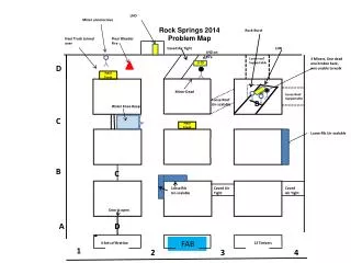
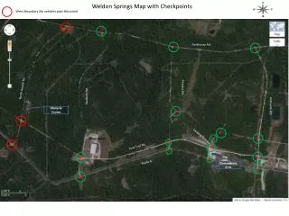
This document outlines the west boundary restrictions indicating no vehicles are permitted past the specified point on 18.13 Packhouse Road. The accompanying map illustrates critical checkpoints along North Howell Road, Pitmans Road, Ausburn Road, and Ordnance Road. Additionally, it includes details about the obstacle course, landing strip road, warehouse locations, tank trail roads, and route access to the cantonment area. For logistical planning and navigation purposes, this information is essential for traversing the designated areas effectively.

West Boundary Restrictions and Map Overview with Checkpoints
E N D
Presentation Transcript
West Boundary No vehicles past this point 18 13 Packhouse Rd. 12 4 Weldon Springs Map with Checkpoints North Howell Rd. Pitmans Rd. fAusburn Rd. Ordnance Rd. Obstacle Course 11 17 5 3 Landing Strip Rd 6 Ware House. 10 16 Tank TrailRd. 7 9 2 14 8 Route A Cantonment Area 1 15