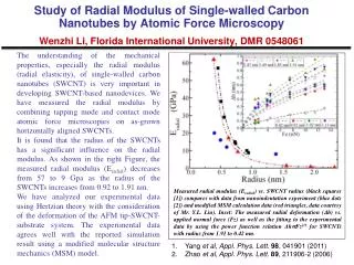
Download
1 / 24
240 likes | 410 Vues
NASA’s Applied Remote Sensing Training Program ( ARSET): Connecting Stakeholders to NASA Earth Science and Principal Investigators. Pawan Gupta, Ana. I. Prados , Rich Kleidman , Yang Liu, Jacque Witte et al., NASA Goddard Space Flight Center GESTAR/USRA/JCET/UMBC/SSAI.

E N D
NASA’s Applied Remote Sensing Training Program (ARSET): Connecting Stakeholders to NASA Earth Science and Principal Investigators Pawan Gupta, Ana. I. Prados, Rich Kleidman, Yang Liu, Jacque Witte et al., NASA Goddard Space Flight Center GESTAR/USRA/JCET/UMBC/SSAI
Applied Remote Sensing Training (ARSET) GOAL: Increase utilization of NASA observational and model data for decision-support • Objectives: • Provide end-user communities and institutions with professional hands-on technical workshops • Build long term partnerships with end-user communities and institutions in the public and private sectors ARSET disseminates the usage of existing NASA data, web tools, Decision Support Systems and applied research, in addition to collaborating with other capacity building programs within NASA
Applied Remote Sensing Training Program (ARSET) • Online and hands-on courses: • Who: policy makers, environmental • managers, modelers and other professionals • in the public and private sectors. • Where: U.S and internationally • When: throughout the year. Check websites. • Do NOT require prior remote- sensing • background. • Presentations and hands-on guided • computer exercises on how to access, • interpret and use NASA satellite images for • decision-support. NASA Training at CMAS
Gradual Learning Approach Basic Courses Webinars Hands-on Assumes no prior knowledge of RS Advanced Courses Hands-on Webinar course generally required Focused on a specific application/problem: for example products and tools for flooding applications in Colombia
Increasingly Popular Webinar Courses Screen shot from ARET advanced webinar series offered in July 2012 . Software interface provides two-way visual and audio connectivity, as well as the chat capability (lower left). Presentations are recorded for those who cannot participate in real time.
ARSET Training Workshop Lifecycle • Advertise via list-serv and Webpage • Collaborate with NASA Applied Science PIs • Collaborate with NASA Data Centers • Work with Advisory Group • Attend professional conferences Conduct Training : Online Presentations Hands-on activities Case Studies Identify Host Institution End-user Needs Assessment Adapt training modules Project Evaluation: Surveys and Feedback
ARSET Trainings by Societal Benefit Area 2009 – 2013: +900 End-users Reached
ARSET Reach Update: 2009 – June 2013 Number of participating organizations per state (AQ + Water): County State Tribal Academic Private Sector • Federal Agencies: • NOAA, USGS, USAID, USACE, BLM, Bureau Rec • NOAA, US Forest Service, National Park Service, EPA • NOAA, USAID, USGS
ARSET Reach Update: 2009 – June 2013 129 Number of participating organizations per country: Air Quality and Water Resources
Training Activities Coming up: Air Quality • Hands-on course for NESCAUM (Northeast States Coordinated Air Use Management). GOING ON NOW • Online course for Indian air quality professionals in (also supporting SERVIR node in Nepal). Spring 2014. • Hands-on course for Texas Department of Environmental Quality (TCEQ) Course Dates: February 24-27, 2014 Location: Austin Texas
Consider participating in an ARSET Training • ARSET works directly with NASA funded PIs. • You can participate online or during an in-person training. • Share with a wide end of end-users (100-200 for online courses) your research, methods, or decision support tools - become rich and famous !! Disclaimer…….
http://airquality.gsfc.nasa.gov/ Publicly available Modules Case Studies Upcoming trainings
ARSET Web Sites and Updates http://water.gsfc.nasa.gov/ (Water) http://airquality.gsfc.nasa.gov/ (Air Quality) Updates and notification of upcoming workshops: Water Resources/Disasters https://lists.nasa.gov/mailman/listinfo/nasa-water-training Air Quality https://lists.nasa.gov/mailman/listinfo/arset
Air Quality Topics • Fundamental of Satellite Remote Sensing • Introduction to Current Earth Observing Satellites • Image Access and Interpretation • Satellite data format and levels • Introduction to Aerosols and Trace Gas Sensors • MODIS Aerosol Products & Application • MISR & OMI Aerosol Products & Application • PM2.5 analysis using satellite data • OMI Trace Gas Products and Applications • Fire Products from MODIS, GOES, VIIRS • AERONET • VIIRS, MODIS 3Km, MAIAC, …
Online Tools/Web Services • HDFLOOK • IDL • PANOPLY • Google Earth • GIOVANNI • MODIS Today • MODIS rapid response • Worldview • MODIS-Atmosphere • LADSWEB • IDEA • AERONET Synergy tool • Earth Observatory • Smog Blog • CALIPSO Browse Image • Hazard Mapping System Fire and Smoke Product
Panoply – to map the data Can be output as KMZ file for Google Earth
Some of Examples of hands on Training Modules Training Module: From Satellite to PM2.5 to Air Quality Index Training Exercise developed by Pawan Gupta . Course attendees compute satellite derived Air Quality Index (AQI) for the LADCO region with instructor provided IDL code and export it to excel. The last two columns show a comparison of satellite and ground based AQI. Satellite and surface measurements generally agree in predicting these categories. Satellite versus monitor AQI for the U.S Midwest
Creating Air Quality Category Map Provide MODIS AOD file, slope and intercept to this code – will create AQC map
RGB Dust Detection – Data Processing Chain TEST # 1 TEST # 2 TEST # 3 AOD DUST TEST # 4
Wish List for VIIRS data • Easy Data Access • Data & Geo-location/metadata in the same file • Larger granule size if possible • Online and offline tools to read/map/analysis the data • Image Archives for RGB, Level 2, & 3 • Integration into online visualization tools • GIOVANNI • IDEA • Worldview • Data Search Tool – ECHO-REVERB • LAADS Web
ARSET Team Members Project Lead Ana Prados (GSFC/UMBC) • Air Quality • Pawan Gupta (GSFC/GESTAR/USRA) • Richard Kleidman (GSFC/SSAI) • Yang Liu (Emory University) • Jacquie Witte (GSFC/SSAI) • Ecological/Land Management • Evan Johnson (Student/AMES/Baeri) • Cindy Schmidt (AMES/Baeri) • Water Resources • Brock Blevins (Student/UMBC) • Chris Mattmann (JPL/Caltech) • Amita Mehta (GSFC/UMBC) • Tom Painter (JPL/Caltech) Program Evaluation Annelise Carleton-Hug (Trillium A.) Administrative Support Marines Martins (GSFC/SSAI) Module Translation (Spanish) David Barbato (Student/UMBC)