Sapporo, 17 Oct 2011
PRAGMA 21 Worshop. VAST’s GeoGrid IT Infrastructure Research and Solution Proposal Dao Van Tuyet , Nguyen Van Thuong Nguyen Thanh Tung,Vu Duc Thi . Vietnam Academy of Science and Technology , . Sapporo, 17 Oct 2011. 1. 3. 2. 4. Outline. Background . Grid enabled Geoinformatics.


Sapporo, 17 Oct 2011
E N D
Presentation Transcript
PRAGMA 21 Worshop VAST’s GeoGrid IT Infrastructure Research and Solution Proposal Dao Van Tuyet, Nguyen Van Thuong Nguyen ThanhTung,VuDucThi. Vietnam Academy of Science and Technology , • Sapporo, 17 Oct 2011
1 3 2 4 Outline Background Grid enabled Geoinformatics VAST IOIT/ IAMI visit AIST/ ITRI for training Discussion and Conclusion
BACKGROUND + VAST-AIST workshop in HCM city 2009 + PRAGMA 17 + GEO Grid WS, Oct 2009 in Hanoi. + AIST endorsed VAST-IOIT’s Grid proposal by Prof. Vu DucThi .
BACKGROUND + Signing Ceremony, June 2010 in Hanoi + AIST proposal accepted by MEXT, Japan + JRA :” Implementation and evaluation of GEO Grid Infrastructure in Vietnam , Nov 2010
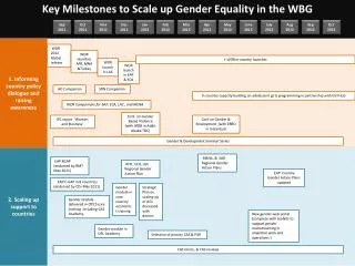
PRAGMA, OGC, OGF • VAST, Vietnam • 1. Development of GEO Grid Infrastructure in Vietnam • 2. Understanding Physics, Mathematics used in weather research and firecasting model • 3. Evaluation of Asia GEO Grid Infrastruture • NIES, Japan • AsiaFlux Network AIST, Japan • NSTDA/ NECTEC, Thailand’ • Promotion of collaboration with ThaiFlux • Development of “Information Grid” and “Enviroment • NARL/NCHC, Taiwan • 1. Development of near-real-time pipeline for processing satellite images to support in-situ image data to disaster prevention center • Support TaiwanFlux to provide Flux data by GEOGrid middleware Overview – ASIA GEO Grid Initiative Project Formation
Overview – IAMI e- Infrastructure • Grid site(s) using gLite: • Keylab site (3CPUs / 6Servers - certified) http://goc.grid.sinica.edu.tw/gstat/VN-IOIT-KEYLAB/ • CNRS site (2CPUs / 6Servers - connect to VinaREN network)
Activities (2/3) • connected institution
Main Support Roles • HCMC University Medical Center – Vietnam: • Research about Ophthamology using HOPE on the Grid System • Co-Support Organization: HealthGrid – Celermont ferrand (France) • Contact person: • Dr. Tran Anh Tuan - dr.trananhtuan@gmail.com • IAMI’s Researcher : Nguyễn Thanh Tùng – tungnt@vast-hcm.ac.vn • Pasteur Institute HCM City – ARBOVIRUT LABO • Using GVSS Tool to do research on Dengue Fever NS3 • Design and implement the system to manage the samples for ARBOVIRUS LABO • Building the database for saving and presenting the Influenza Virus A H5N1, H1N1 • Co-support Organization: Institute of Sinica (Taiwan) • Contact persons: • Dr.VuThiQueHuong - quehuong@pasteur-hcm.org • Dr.Huynh Chuong - huynh@bioinfohelpdesk.org • IAMI’s Researcher: Nguyễn Thanh Tùng – tungnt@vast-hcm.ac.vn
HOPE – Platform (3/3) IAMI has built and succesfully implemented one CNRS Grid site with 6 servers. HOPE has been implemented on UI server and ready for connection at link: http://ui.iami.vngrid.vinaren.vn:8080/gridsphere/
1 3 2 4 Outline Background Grid enabled GeoInformatics VAST IOIT/ IAMI visit AIST/ ITRI for training Discussion and Conclusion
■ Earthquake research, monitor, hazard reduction
IES2008 Earthquake research, monitor, hazard reduction
AIST- VAST GEO Grid Initiative Project: Some activities in Vietnam • 1.Development of GEO Grid Infrastructure in Vietnam • 2.Understanding Physics, Mathematics used in weather research and forecasting model. • 3.Evaluation of Asia GEO Grid Infrastructure.
Summaryof the2006- 2009 Pacific typhoon seasons 2008 2007 2009 2006
Vietnam 2009 typhoon season Viet Nam is amongst the most disaster prone countries of the world Tropical Storm Soudelor July 9-11 • massive floods • houses are destroyed and many more damaged • damage to housing and infrastructure • losses to agriculture and fisheries • loss of life Tropical depression September 4-9 Tropical Storm Mujigae September 8
Tropical Storm Soudelor (July 11, 2009) International designation: 0905; Higgest winds 65 km/hr JTWC designation: 05W; Lowest pressure 992 mbar PAGASA designation: Gorio • 4,000 fishing vessels were ordered to return to port. • Up to 200 volunteers were mobilized to deal with damages from the storm • Officials evacuated people from 297 residences to higher grounds and reported that 977 other homes were in threatened areas. • Roughly VND71 billion (US$3.98 million) was set aside by the Government of Vietnam to assist residents in natural disasters, including Soudelor. • An estimated 5,000 sandbags and 1,000 cubic meters of canvas were distributed to flood-prone areas. • The remnants of Soudelor produced widespread torrential rains in Northern Vietnam on July 13. Rainfall totals peaked at 250 mm (9.8 in) in the region.Heavy rainfall, amounting to 130 mm (5.1 in), was also recorded in Hanoi. The capital city experienced flash flooding, inundating numerous streets and buildings. Two men were killed by lightning strikes associated with the storm. Officials reported that at least 13 large trees had been downed by high winds.Flood waters in the hardest-hit areas reached a depth of 0.35 m. One person was killed after being swept away. • A tornado also touched down during the storm, destroying the roofs of three homes. Thousands of hectares of croplands were inundated by flood waters. Following the storm, 1,000 tonnes of rice was allocated for victims of the floods.
Sequential procedure to detect the typhoon beginning Main problem is formulation of the criterions that explain the laws of the typhoon origin. Typhoon category 1.0 0.9 0.8 0.7 0.6 0.5 0.4 0.3 0.2 0.1 0.0 5 4 3 2 1 Storm Indicator value (Relative units) Tropical Depression Background zone Running time
Oceanic water temperature < 27C North America South America Point of the hurricane origin 2005: 5 tropical depressions from 31 were formed under the ocean water temperature less 27C and 10 from them were formed in the regions of active tectonism.
Temperature as Indicator of Tropical Cyclone Origin Atlantic Ocean North-West of the Pacific Ocean Temperature Temperature Northern Indian Ocean North-East of the Pacific Ocean Temperature Temperature
Atlantic hurricane season and ocean water temperature T < 27C North America T27C Place where hurricane was began in 2005. South America
6-hourly snapshots of the wind speed in 6-km resolution of prognostic system WRF (Weather Research and Forecasting) simulation of hurricane Dean starting from 00:00 30.08.2007 to 00:00 02.09.2007. Trajectory of the hurricane Dean during the Hurricane season of 2007. red dots correspond to the category 5 stage.
WRF4G FUTURE PLAN AT IAMI/ VAST • WRF4G is a part of the WRF Modeling System to GRID environments • It consists of slight modification to the WRF source + a set of wrapper scripts to interact with the GRID • A set of user scripts permits a flexible design of experiments consisting of realizations which can span different physics/parameters and/or a sequence of independent hindcasts
1 3 2 4 Outline Background Grid enabled GeoInformatics VAST IOIT/ IAMI visit AIST/ ITRI for training Discussion and Conclusion
VAST IOIT/ IAMI (IT engineers) visit AIST/ ITRI • OCT 11- 13 training, OCT 14 Lab. Tour • AIST will send “ Packages to Learn” ‘ Area of study: Grid, Globus, OGC standards, Cloud/Virtualization, OS/ System software, Ninf-G (programming) Application: What kind of application ? Should be identified toward the Climate Change Program: Disaster mitigation, Weather Research and Forecasting for Grid (WRF4G),Natural resource discovery, Global warming.
VAST – AIST Bilateral workshop 2011 • 1stGeoGrid School in VAST for IT researcher Lectures: Dr. Sato Sekiguchi, Dr. Yoshio Tanaka, and others • School In Hanoi: Nov 28 (Monday) : Grid, Globus, OGC standards, Cloud/ Virtualization, OS/ System software Nov 29 (Tuesday): Ninf- G, Middle ware deployment and development
VAST – AIST Bilateral workshop 2011 • School In HoChiMinh city: Nov 30 (Wednesday) : Grid, Globus, OGC standards, Cloud/ Virtualization, OS/ System software Dec 01 (Tuesday): Ninf- G, Middleware deployment and development.
1 3 2 4 Outline Background Grid enabled Geoinformatics VAST IOIT/ IAMI visit AIST/ ITRI for training Discussion and Conclusion
Discussion • Computing Technology Research Center in VAST should be suggested in 2012. • Building the collaboration research in VAST ( IT & Geo Infrastructure) to find the solution to adapt with Climate Change in the Mekong Area. • More human power (IT & Application researcher of VAST ) in the CTRC for Geo GRID. • More application should be identified for approaching to Climate Change prediction in the Program of MOST in Vietnam. (R&D support by ITRI/ AIST)