Download
1 / 46
460 likes | 600 Vues
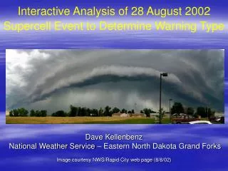
Interactive Analysis of 28 August 2002 Supercell Event to Determine Warning Type. Dave Kellenbenz National Weather Service – Eastern North Dakota Grand Forks Image courtesy NWS/Rapid City web page (8/8/02). Area of interest where supercell developed. Objectives. Synoptic Overview

E N D
Interactive Analysis of 28 August 2002 Supercell Event to Determine Warning Type Dave Kellenbenz National Weather Service – Eastern North Dakota Grand Forks Image courtesy NWS/Rapid City web page (8/8/02)
Objectives • Synoptic Overview • Surface analysis and brief sub-synoptic/mesoscale overview • Stability and shear indices overview • Evolution of supercell and warning decision scenarios along the way • What weather was produced by supercell • Hypothesis and Research into event
250 Hpa 8/29/02 – 00 UTC Departing Right entrance region of 30kt jet and upper divergence near area of interest
500 Hpa 8/29/02 – 00 UTC Weak shortwave moves through
850 Hpa 8/29/02 – 00 UTC 20-25kt Jet during supercell lifecycle
Surface Map at 20 UTC Wahpeton, ND Wind Dir @ 20Z 169 degrees at 12 mph
Surface Map at 23 UTC Wahpeton, ND Wind Dir was 100 degrees @ 23Z at 21 mph, as winds back and increased with enhanced inflow into supercell.
Model RUC sounding near Wahpeton at 20 UTC Fairly weak flow with high instability (CAPE 3870 J/Kg) and only 3 J/Kg CIN, freezing level 13,200 ft
Hodograph at 20 UTC 0-3km SRH between 90-110 M2/S2 EHI 2-2.5
Warning scenario #1 (2113-2128 UTC).5 Reflectivity Loop (KMVX) Supercell developing rapidly in 20 minutes
Radar Cross Section and 0.5 Reflectivity-KMVX Supercell begins to develop with elevated core 2113 UTC 2114 UTC
10-15 minutes later Supercell has developed rapidly with 50-55dbz core up to 40k ft 2124 UTC 2128 UTC
Mid level reflectivity 2114 UTC and 2120 UTC Reflectivity core grows quickly in 6 minutes, as VIL inc by 26 Kg/m2 VIL = 31 (Kg/m2) VIL = 57 (Kg/m2)
Mid level reflectivity at 2125 UTC and SRM at 2129 UTC Some weak cyclonic and anti-cyclonic rotation VIL = 62 (Kg/m2)
Warning decision time, what to do? • No reports of severe weather as of 2129 UTC or 429 pm. • A) Tornado warning Richland/Wilkin County? • B) Severe Thunderstorm warning Richland/Wilkin County? • C) Flash Flood warning Richland/Wilkin County? • No warning needed, go get some coffee Quarter size hail reported in Wahpeton at 2133 UTC, along with numerous other dime-quarter hail reports until 2145 UTC
Warning scenario #2 (2130-2200 UTC).5 Reflectivity Loop(KMVX)
2.4 Reflectivity/SRM 2139 UTC (KABR) Weak mid level circulation
0.5 Reflectivity/SRM 2142 UTC (KABR) Weak circulation now showing up in lowest slice
Base Reflectivity at 2143 UTC & 2149 UTC (KMVX) TVS indicated over Wahpeton with inflow notch developing
Reflectivity Cross Section at 2154 UTC Good elevated core with some tilt and slight BWER
0.5 Reflectivity/SRM 2153 & 2158 UTC (KMVX) Hook echo trying to form Spotter report from Wahpeton – “wall cloud beginning to form with scud lifting rapidly into updraft @ 2155 UTC” 2153 UTC 2158 UTC
Warning Decision time, what to do at 2200 UTC? • A) Keep Severe Thunderstorm Warning going • B) Upgrade to Tornado Warning • C) Issue Flash Flood Warning • D) Drop all warnings and send everyone home • E) Time for more coffee !!! Stay Tuned !!!
Warning scenario #3 (2158-2245 UTC).5 Reflectivity Loop(KMVX)
0.5 Reflectivity 2203 & 2208 UTC (KMVX) Hook trying to develop with strong updraft noted by “donut hole” at 2208 UTC 2203 UTC 2208 UTC
0.5 Reflectivity 2213 & 2218 UTC (KMVX) Spotter reports of rapidly rotating wall cloud
Base Ref 2233,2238 and 2243 UTC (KMVX) Signs of RFD developing and inflow beginning to fill in with precipitation, still well defined wall cloud/funnels over Wahpeton
0.5 Reflectivity/2.4 SRM 2247 UTC (KABR) Weak Mesocyclone still present one hour after supercell develops
Warning(s) are expiring, what to do at 2245 UTC? • Gettting reports of wallcloud/funnel clouds from 2155-2245 UTC near Wahpeton • VIL ranging from 60 to 65 Kg/m2 during time frame • A) Flash Flood warning • B) Severe thunderstorm warning • C) Tornado warning • D) Make some coffee because it’s gonna be a long night Stay Tuned !!!
0.5 SRM 2254 UTC and 2259 UTC(KMVX) gate to gate shear in lowest elevation angle for consecutive scans
Spectrum Width at 2254 UTC SW indicating turbulence at same time TVS indicated over Wahpeton
Base Ref. 2238-2319 UTC (KMVX) Hook quickly fills as precipitation chokes supercell updraft
Ref @ 2254 UTC and SRM @ 2259 UTC TVS triggered 2254 UTC with pronounced hook echo at 2259 UTC
What do you think the supercell produced ? • Tornado/Hail/Flash Flooding • Just some Hail • Hail and Flash Flooding Answer: C - No Tornadoes were reported, with many hail reports up to golf ball size along with Flash Flooding Wall clouds/funnel clouds and strong rotation were reported from 2155Z until 2300Z in Wahpeton ND Spotters reported that “they thought a tornado would form at any minute” Continuous training and re-development of cell(s) produced 3 to 6 inches of rain and caused flash flooding in Wahpeton, ND and surrounding areas
Warning thought process • Numerous reports of wallclouds/funnel clouds in combination with radar signatures through lifecycle of supercell influenced warning decisions • Radar signatures also indicative of tornadic potential although not classic • Severe thunderstorm warning issued at 2129 UTC for Richland/Wilkin County • Upgraded to tornado warnings at 2200 UTC and continued until 2330 UTC • Flash Flood warnings issued at 2307 UTC with many flood reports from 2330 UTC until 0130 UTC
Favorable LCL Height LCL height of 831m (2,227ft) fell almost into center of non significant tornadoes F0-F1 and into upper range for Significant tornadoes (F2-F5), lower range for non-tornadoes Edwards and Thompson 2000
Favorable LFC Height LFC Height of 1,120m(3,676ft) fell between non-significant and significant tornadoes Davies 2002
CAPE and 0-3km SRH comparison 4000 CAPE and around 100 SRH in range with both tornadic and non tornadic supercells Edwards and Thompson 2000
Images of Supercell taken by storm chaser Mike Hollingshead Classic Wall cloud and funnel clouds
Favorable factors for tornadogenesis • Ideal LFC(1,120m or 3676ft) and LCL(831m or 2727ft) heights from Davies (2002) and Edwards/Thompson (2000) guaranteeing a more surface based supercell and lower CIN • Favorable radar signatures for up to one hour • Approaching low pressure which helped back low level flow thus increasing 0-1km SRH and focus inflow • High instability
Negative factors for tornadogenesis • Only little tilt of supercell with precipitation core over updraft • Deep layered shear was rather weak • Numerous cells eventually developing in same area cutting off inflow to supercell • Little movement of supercell enabled updraft to ingest rain cooled air
Possible Cold RFD at work cold downdraft air is not easily ingested by the updraft Markowski 2003
Images of Supercell taken by storm chaser Mike Hollingshead RFD undercutting updraft and wrapping rain cooled air into it
Schematic and picture of warm RFD warm downdraft air is readily ingested by the updraft Markowski 2003
Hypothesis and future research • Deep layered shear may have been a bit too weak…but shear was high ? • Best rotation remained under core of storm, and supercell remained nearly stationary which likely lead to “cold” type RFD • Needs to be more research on tornadogenesis failure, as these are the toughest cases • Possible real time analysis of RFD type (cool/warm) using LFC/LCL and proximity soundings/sfc reports would help reduce tornado FAR • Local study with UND to compare LCL/LFC height with past tornado/non-tornado cases to determine in effort to classify RFD type for northern plains area with downdraft model written by Mark Askelson
Questions, Comments ??? Dave Kellenbenz National Weather Service Eastern North Dakota Grand Forks David.Kellenbenz@noaa.gov