C uronian spit
Kamilė Skaraitytė IV g . C uronian spit. Welcome to Curonian spit.

C uronian spit
E N D
Presentation Transcript
Kamilė Skaraitytė IV g Curonian spit
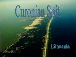
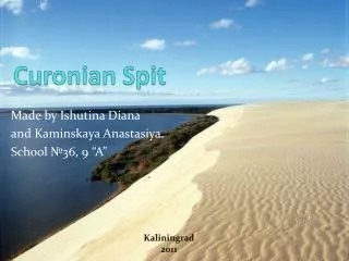
Welcome to Curonian spit The CuronianSpitis the unique nature creation of 98 km long, thin, curved sand-dune that separates the Curonian Lagoon from the Baltic Sea coast. Its southern part lies within the most western region of Russia, Kaliningrad, and its northern part lies within southwestern Lithuania. It is a UNESCO World Heritage Site shared by two countries.
Places of interest : • Smiltyne • Juodkrante and surrounding area • Pervalka • Preila • Nida and surrounding area
Smiltyne Smiltynė is a part of Klaipėda city municipality in Lithuania. It is located on the northern tip of the Curonian spit, next to a narrow strait which connects the Curonian Lagoonto the BalticSea.
LITHUANIAN SEA MUSEUM, AQUARIUM AND DOLPHINARIUM The Lithuanian Sea Museum is located in Kopgalis, the northernmost point of the Curonian Spit. In 1979, the main exhibits of the Lithuanian Sea Museum were put on display there. In 1994 a dolphinarium was opened, the last item in the Lithuanian Sea Museum complex, which covers all areas of human relations with the sea. The comprehensive approach makes our museum different from other Sea museums of Europe.
KOPGALIS VILLAGE CEMETERY Kopgalisvillage cemetery (the 19th - beginning of the 20th century). The first Lithuanian captain L. Stulpinas (1871-1934) and governor of Klaipeda region, poet-publicist Jonas Zilius - Jonila (1870 - 1932) are buried there.
ETHNOGRAPHIC FARMSTEAD OF FISHERMAN An ethnographic fisherman's farmstead has been built in 1977–1979 on the shore of the Curonian Lagoon at the place where the old Kopgalis fishing village used to stand. The farmstead comprises a farm, cattle-shed, store, bathhouse, cellar and smokehouse. The interior of the buildings were restored to reflect the beginning of the 20th century.
Juodkrantė Juodkrantėis a quiet Lithuanian seaside resort village located on the Curonian Spit. A part of Neringa municipality, Juodkrantė is the second largest settlement on Lithuania's part of the spit.
WEATHERVANES GALLERY At the Daiva and RemigijusŽadeikis Weathervanes Gallery you can learn about the history of their origins and evolution, see various examples, and purchase weathervanes. The Gallery has literature for tourists, original ceramic and textile items, and other works of art.
WITCHES' HILL The major attraction of the hill is the park of wooden sculptures. It was set up in 1979 according to the project developed by the sculptor S. Sarapovas and architect A.Nasvytis. Forty nine artists carved sixty five sculptures, which embodied the heroes and characters of Lithuanian fairy-tails and legends. Each year some sculptures are restored or replaced with others.
JUODKRANTE CHURCH Juodkrante Evangelic Lutheran Church was built in 1884-1885 by the initiative of Juodkrante preacher O. E. Richter. After World War II the church was turned into a warehouse. It was restored in the seventies; windows were decorated with a stained glass. For some time it was used by the Miniatures Museum. In 1989 the building was given back to the church.
Nida Nidais a resort townin Lithuania, located on the CuronianSpit. Nidais the administrative center of the Neringa municipality. NidaAirport is located in the town. Nida is the westernmost point of Lithuania and the Baltic States.
HISTORICAL MUSEUM OF NERINGA This exhibit represents such traditional occupations in the Curonian Spit as fishing, catching crows and others. The artifacts belong to the Neringa History Museum, which has rich collection of fisherman's tools. Visitors will find here the models of kurenas and great kurenas - traditional fishing boats in the Curonian Spit, made by the old Nida's fisherman MikelisEngelinass.
AMBER GALLERY-MUSEUM The exhibition in the Amber Gallery tells about the origin of amber, its excavation and exploitation. Visitors will learn about ancient amber forests, amber from other countries and colours of amber. In the gallery they will find the unique collection of enclosures, R.Klebs'es treasure of Juodkrante and single copies of amber crafts by Lithuanian jewellers. Jewellery exhibitions take place here in summer. Any time visitors can buy souvenirs or amber jewellery here.
PARNIDIS COGNITIVE PATH The cognitive path of 1800 m is laid in the southern part of Nida settlement. The path begins at the Valley of Silence. It is the name the locals gave a meadow at the foot of the dune, where lee and rest can always be found. There you can observe various plants, lichens, mushrooms, insects, birds, amazing landscapes, and visit woodpecker’s “smithy”. Pointers mark the beginning and the end of the itinerary. The itinerary of the cognitive path is marked by wooden poles with green and white upper brims. Separate objects are marked by information stands with short descriptions.
PARNIDIS DUNE AND SOLAR CLOCK A view point is set up on the top of Parnidis Dune. It is one of the most popular tourist sites in Nida environs. In 1995, a solar clock was built there. The author of this idea was architect R. Kristapavicius, K. Pudymas sculpted it and R. Klimka made astronomic calculations. The location was chosen by design: the Curonian Spit is the only place in Lithuania where the sun rises from and sets into the surface of water. Till the hurricane “Anatoli”, which stormed in the Curonian Spit on 4 December 1999, the height of the clock’s pointer was 12 m (2 m underground) and its weight was 200 t. After the hurricane, only half of it was left. The pointer is ornamented with calendar celebration symbols copied from the XVII century wooden rune calendars.
Pervalka Pervalka - village on the CuronianSpit, Neringamunicipality, 5 miles north of Preilaand 15 miles south of Juodkrantė.
LIGHTHOUSE OF HORSES The lighthouse was constructed in 1900 in the Curonian Lagoon beside Pervalka, behind Agilos gulf, facing Horses Cape rising across Birstvynas. It was reconstructed twice. Currently in action. Is reachable by a ship and can be seen from the Curonian Spit shore.
L.M.REZA‘S SCULPTURE ON THE SKIRPSTAS DUNE Karvaičiai village is the homeland of one of the most famous folklorists and poets of the beginning of the 19th century, professor of Königsberg University LiudvikasMartynasRėza (1776–1840). He was the first to publish „Metai“ (Year) by K. Donelaitis in 1818, later – the fables, in 1825 he published the first collection of the Lithuanian folk songsSongs. The wooden sculpture to L. G. Rėza by the folk artist E. Jonušas was erected in 1979 on the Skirpstas Dune near Pervalka.
NAGLIAI STRICT NATURE RESERVE Nagliai Strict Nature Reserve covers an area of 1680 ha. It is 9 km long and lies between Juodkrante and Pervalka. The most significant in the reserve are the Grey (Dead) Dunes, which are covered with grass vegetation. Underneath are places of old villages that were buried by drifting sand, naturally grown forest and ancient forest soils. In places where the wind blew out deep hollows, the cultural strata of old settlements and buried forest soils can be seen. This reserve is a sanctuary for a number of species, which are included in the Red List
Preila Preila – village on the Curonian spit, Neringa minicipality.
VECEKRUGAS DUNE Vecekrugas Dune (the Old Inn Hill) is the highest dune in the Curonian Spit National Park – 67,2 m. The name of the dune originates from the Curonianvece – old and kruogs – inn, reminiscent of the inn that used to be at the foot of the dune. The entire dune is overgrown with the dwarf mountain-pines (PinusmugoTurra). The Vecekrugas Hill and the surroundings thereof are announced to be the Karvaičiai Landscape Reserve, the area of which is 3 043 ha.
Video • http://www.youtube.com/watch?v=y37YobcEJPU • http://www.youtube.com/watch?v=5iKYnAZGUP8