Download

1 / 37
380 likes | 632 Vues
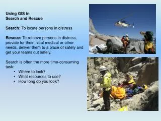
What is Search and Rescue? Search: To locate persons in distress Rescue: To retrieve persons in distress, provide for their initial medical or other needs, deliver them to a place of safety and get your teams out safely. Search is usually the more time-consuming task: Where to look?

E N D
What is Search and Rescue? • Search: To locate persons in distress • Rescue: To retrieve persons in distress, provide for their initial medical or other needs, deliver them to a place of safety and get your teams out safely. • Search is usually the more time-consuming task: • Where to look? • What resources to use? • How long do you look?
The Map is Not the Territory • A map is not the territory it represents, but if correct, it has a similar structure to the territory, which accounts for its usefulness. • -- Philosopher and Scientist Alfred Korzybski, 1931 • Role of GIS in SAR: • Ability of GIS to better visualize situation • Graphically show search area on regular maps, 3D • Tell the story of the SAR through maps • Routines to more quickly delineate search area: • Determine how far a person can travel (cost surface models) • Buffers around trails as search segments • Use natural features to create segments • Use GIS to capture local knowledge (e.g. terrain traps or attractive nuisance (mine shafts etc) • Use GIS to otherwise narrow or highlight search areas (e.g. Ginseng areas; cross country routes etc.) • Integrate technology (GPS, Satellite tracking options etc) into GIS to increase safety of teams and reduce time of planning cycles. • Archive entire incident for later review, legal challenge or to renew search when conditions improve.
Arc products are often thought too difficult to use without a long learning curve. Pre-planning of resources, prior creation of data structure and project files, and a basic workflow reduces this curve significantly. • Pre-Planning • Assemble Minimum Essential Databases: • Put MED on portable hard drive or local network. • Create New SAR mxd & folder structure to be renamed to actual SAR • Create MXD with MED for initial planning • Consider pre-segmenting area of responsibility. • Write defaults (datum, units etc) for GIS section’s IAP. • Train field people to use GPS & collect GIS points such as: • Point Last seen • Planning location • Clue locations • Track logs of initial/hasty search
Proposed File Naming Conventions Root Folder • YYYY_SARs SAR Folder: • SAR-NAME_SAR#_yyyymmdd • Alternate??: YYYYMMDD_SAR-NAME_SAR# Project File Name • yyyymmdd_time_SAR-Name_SAR#_MapType_size-dimensions_PaperType_Orientation_ArcVersion.mxt/mxd or • SAR-Name_SAR#_MapType_size-dimensions_Paper-Type_Orientation_ArcVer.mxt/mxd • Also: Minimum Essential Dataset (MED) for area of responsibility • SAR_MED_Park_ArcVersion • Then can Save As Initial Project file and Remove unneeded data or Group out of the way. Incident Data • GPS • OPx_<Date?>_TIME_IncidentName_IncidentNumber_Type(Waypoint-WPT; TrackLog-TRK)_Team#_Datum • GeoSpatial File • Yyyy_SARName_SAR#.mdb Modified Base Data • Original Source Name_Modification (Clip, Segment, Merge)_DateModified Products • Daily OP Maps (PDF) • OPx_<DATE??_TIME_SARName_SAR#_MapType(IAP, Briefing, Work)_MapImagery(3D, SAT, Topo)_Dimensions_PaperSize_Orientation.pdf • Final Situation Maps • Yyyymmdd_time_SARName_SAR#_ MapType(IAP, Briefing, Work)_MapImagery(3D, SAT, Topo)_Dimensions_PaperSize_Orientation.pdf Documents • Yyyy_SARName_SAR#_DocType(GPS Report, GIS Evidence)_AuthorName(LN-FirstInitial_yyyymmdd.doc/docx
Basic Workflow • Actual SAR • Work with Plans & IC to determine map needs. Brief them on GIS capabilities. • Priority to determine SAR perimeter and get containment. • Draw SAR segments. • Begin map production after consulting IC & Plans on needs: • Tabloid or Letter for IAP and Team maps • 3D? • C size for tabletop planning/scratch • E size for Briefing • C or E size Clue map for people to draw in clues as they’re received. GISS then enters them from data or from map. Look for patterns in clues and ensure followup. Cluster of dog alerts?? • After SAR completed • Final situation map (E size) • Archive all data
October 25th, 2009, 0300: Wade Brunette, age 63, starts day hike to Mt. Whitney: 18 mile round trip and 5,000 feet vertical. Last seen 2 miles from summit at 1545 insisting he could still make it up and back to his car. Other party warned him of approaching storm and difficult terrain still ahead. Weather delays SAR until mid-morning 3 days later.
Liz Sarow’s (ESRI) Terrain-driven Cost Surface Model to estimate SAR perimeter and trail block locations
Step 3: create search segments, ICS points (e.g. Helispots, Trail Blocks, Initial Planning points, Hazards, clues etc. Then, Step 4, Save As: SAR_Name.mxd. Remove unneeded files and start clean.
Create segments by snapping to natural feature layers; buffer trail segments out 200 feet to create trail segments
Detail: Whitney Zone Segments & Team Assignments Segments created from snapping to watershed boundaries and other natural features. Trails buffered out to 200 feet and made segments.
Plan for retrieval of GPS tracklogs as quickly as possible. Have computer in field to do so then send out as one file or use Satellite tracking or communication device from field.
Final Situation Map and Downloaded GPS of lost party.
Remote Tracking of Field Teams RoadpostGeoPro Messenger Contact Dan Cassidy Director, US Market Development dcassidy@roadpost.com 905-272-3933 ext 320 www.roadpost.com
ArcGIS Explorer can be set to poll data automatically, giving it the potential to be used as a semi-realtime situation map projected into the Incident Command Post.
Screen Capture GeoPro track projected onto ArcGIS Explorer, Zion National Park
Device Infinity GPS MiiC: Mobile Intelligent Information Console Accessory Contact Philip C. Kirmuss Vice President, Engineering 720-280-3624 pkirmuss@hotmail.com www.wwtechnologiesdirect.com ArcGIS Explorer Add-in which allows real-time tracking from Mic: Edan Cain, ESRI developer for ArcGIS Explorerecain@esri.com (This add-in is not supported by ESRI but by Kirmuss and Cain)
Inmarsat BGAN Contact Jack Deasy Director, Civil Programs InmarsatGovernement Services, Inc 202-248-5184 Jack_deasy@inmarsat.com www.inmarsat.com
CIMMS Collaborative Incident Management System Contact Bob Williams Bob@homemediastorage.com 916-933-1444
Search for T-33 aircraft from 1957 and never found: Using ArcGIS to eliminate terrain to search based on historical use patterns.
Important to train personnel in GIS/SAR workflow But also critical to make Incident Command people familiar with capabilities and potential.
George Durkee: gedurkee@sonic.net Using GIS in SAR for Emergency Responders:http://groups.google.com/group/sar-and-gis This presentation ppt and beta workflow at: ftp://ftp.sonic.net/pub/users/durkee/Downloads/$AR_File$/GoldCountryPPT_DurkeeG_20101201.zip