Download
1 / 50
550 likes | 1.64k Vues
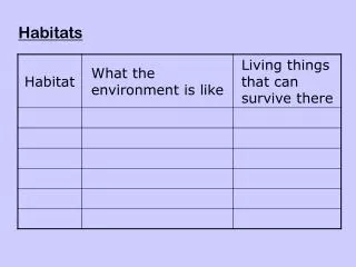
Sibley Nature Center Presents. Habitats of the Llano Estacado. Introduction. Previous Next Page Page. Introduction. The Llano Estacado has one artificial and seven natural habitats. Each is described in an interactive educational presentation called a module.

E N D
Sibley Nature Center Presents Habitats of theLlano Estacado Introduction Previous Next Page Page
Introduction The Llano Estacado has one artificial and seven natural habitats. Each is described in an interactive educational presentation called a module. This Introduction is the same for every module. You only need to read it once, and then you can access each module separately when you are ready for it. To navigate within this presentation, click on the arrow buttons in the lower right-hand corner, or use the arrow keys on your keyboard: The arrow key takes you forward to the next slide. The arrow key takes you back to the previous slide. The Home key takes you all the way back to the first slide.
Introduction You may only have time on your visit to view only the Introduction and one or two of the Habitat modules, but you can always return to the Sibley Nature Center to view the other modules. If you wish to view all of the modules, these presentations will ultimately be available for viewing on CDs or password-protected websites at your home or school—wherever and whenever you have time.
Introduction It is important to view the Introduction presentation first, because it gives you a fundamental understanding of the region and places the specific habitats in context, but the Introduction can be skipped if you have already completed it. If you have already read the Introduction, please click on the Habitat Link below for the habitat you are interested in viewing and go straight to that module.If you haven’t read the Introduction, click on the Next Page arrow button first (or use the right arrow key ). • Habitats of the Llano Estacado • 1. Playas and Playa Lakes • 2. Prairie Brushland • 3. Draws • 4. Canyons and "The Breaks" • 5. Alkali Soils • 6. Shallow Gravel Soils • 7. Sand Dunes • 8. Human Developed Areas Next Page
Introduction to theLlano Estacado The Llano Estacado is Spanish and literally means the Staked Plain or Plain of Stakes. But "staked" or “stakes” for several reasons that have long been the subject of controversy. The region was named the Llano Estacado by Spanish explorer Francisco Vasquez de Coronado in 1541, when he crossed what is now the Texas panhandle. The name still holds today, but why he named it this is not clear.
Introduction to theLlano Estacado The most common explanation is that the original Spanish explorers would drive stakes into the ground to mark their trail to find their way back, a common practice when exploring an unknown flat, featureless landscape, which certainly describes the Llano Estacado. A second idea has it that Coronado’s men had to tether their horses at night using stakes, because if they wandered off they couldn’t be tracked on the soft, short grass. A third suggestion is that the abundant yucca stalks make it appear that the land is “staked.”
Introduction to theLlano Estacado Yet another hypothesis is that the original word was Estacando, not Estacado. This word means “stagnant,” “pond,” or “many ponds,” and if this hypothesis is correct, would refer to the many thousands of playa lakes that are a prominent feature of the Llano Estacado. Coronado was the first European to see a playa, which means beach in Spanish, because many of them had sandy shores. The small ponds eventually dry up and become stagnant mud pits before turning into typical dry playas. A simple misspelling may explain it all. Coronado intended to name the region the Llano Estacando, the “Plain of Many Ponds,” but somehow the “n” got left out of the name by mistake, leaving it spelled Estacado! Unfortunately, no one knows precisely which of these explanations for the origin of the name LlanoEstacado is correct.
Introduction to theLlano Estacado Where is the Llano Estacado? The map shows that most of the Llano is in West Texas, but about 1/3 is in eastern New Mexico. Notice the location of the major cities on the Llano Estacado are all in Texas. From north to south: Amarillo, Lubbock, and Midland.
Introduction to theLlano Estacado Where is the Llano Estacado? Here is a better, more detailed map of the Llano Estacado. The cities of Amarillo, Lubbock, and Midland are printed in red. This map is available in PhotoShop format with a file size of 77.3 MB, so it can be greatly enlarged and still show fine detail. A framed 3’x4’ print of this map can be found hanging on the wall of the Sibley Nature Center, available for viewing. If you click on the map at left, a large version will open up. Try it! (Click the Back button in your web browser to return here.)
Introduction to theLlano Estacado A physiographic name for the Llano Estacado is the Southern High Plains Region of the Great Plains of the United States. The Southern High Plains on the physiographic map at right is the ivory-colored region below the Canadian River and above the Pecos River. A physiographic map of a region shows its physical geography, based on such things as elevation, soil type, bedrock, and geology.
Introduction to theLlano Estacado The Great Plains is an enormous part of the United States, consisting of the entire central part of the country east of the Rocky Mountains and west of the tall-grass prairie states, extending north from the Mexican border well into Canada. This region is colored in orange on the map. Sometimes the Great Plains is termed the Shortgrass Prairie region, because it is a prairie grassland. It has shorter grasses than the tallgrass prairie to the east because it is drier.
Introduction to theLlano Estacado The High Plains is approximately the same as the Southern Great Plains, a large area consisting of western Nebraska and Kansas, eastern Colorado, the panhandles of Oklahoma and Texas, and the Southern High Plains of West Texas and eastern New Mexico. The Southern High Plains is essentially the same region as the Llano Estacado, approximately the southernmost quarter of the Great Plains.
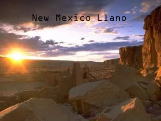
Introduction to theLlano Estacado What is the Llano Estacado? The Llano Estacado is a plateau, a regional landmass consisting of horizontally-bedded sedimentary rocks or strata that has been gently uplifted by tectonic forces of the Earth. The uplift was gentle—not violent as with mountain building, which twists and breaks the rocks—so the sedimentary rocks of a plateau are still relatively horizontal. The uplift was caused by heat below the plateau that comes from deep within the Earth.
Introduction to theLlano Estacado The best example of a plateau in the United States is the giant Colorado Plateau of southern Utah and Colorado and northern Arizona and New Mexico, the famous Four Corners Area. The Llano Estacado in many ways is just a smaller version of the Colorado Plateau, but there are some important differences.
Introduction to theLlano Estacado Characteristically, millions of years of weathering and erosion create beautiful and scenic landforms on plateaus, such as canyons, buttes, mesas, and pinnacles. Depending on the age and timing and amount of uplift, these landforms can have high relief (relief is the difference in elevation between the highest and lowest areas) as in the Colorado Plateau, seen in the photo at right. The famous East and West Mitten Buttes in Monument Valley, Arizona. Note the high relief.
Introduction to theLlano Estacado Landforms can also have low topographical relief, as is the case with the Llano Estacado. Low relief means the area is relatively flat (see photo), and this certainly characterizes the Llano Estacado. Topography refers to mapping the land in terms of elevation and relief, so a topographic map shows a region’s elevation and relief to one who can read it. The entire U.S. has been mapped topographically. Rattlesnake Racetrack, just off Rankin Highway in Midland County, has low relief.
Introduction to theLlano Estacado Canyons on the Colorado Plateau are deep with steep canyon walls, such as the Grand Canyon, but canyons on the Llano Estacado are relatively shallow with gentle slopes and low bluffs that can simply be termed valleys. The reason is because the Colorado Plateau has undergone recent uplift, so erosion now is extremely active, while the Llano Estacado’s uplift occurred long ago, so erosion by now has worn down the land to a condition of low relief. Playa Lake on the Llano Estacado. Note the shallow depression on otherwise flat topography (low relief).
Introduction to theLlano Estacado High relief in the Llano Estacado? Yes! The Llano Estacado does have some areas of high topographic relief. These are found along the edges of the plateau, where the land drops precipitously from the top of the plateau to the valley below. These steep edges or cliffs are called escarpments. The eastern edge in Texas is the Caprock Escarpment, and the western edge in New Mexico is the Mescalero Escarpment.
Introduction to theLlano Estacado High relief in the Llano Estacado? The Caprock Escarpment near Amarillo and Canyon, Texas, is so scenic that a state park was created to protect the area: Palo Duro Canyon State Park. The small Prairie Dog Town Fork of the Red River created the huge Palo Duro Canyon by slowly cutting into the Caprock Escarpment over millions of years. Spectacular landforms, such as famous Lighthouse Rock at left, can be found in the park.
Introduction to theLlano Estacado Palo Duro Canyon State Park The Caprock Escarpment is visible in the photo at right. This wall of horizontally-layered sedimentary rock is the eastern edge of the Llano Estacado. The red color indicates that the sediments were originally deposited in non-marine environments, such as river channels and alluvial plains, and contain an oxidized form of iron called hematite (blood-rock), which can be ground to form a red pigment for artwork.
Introduction to theLlano Estacado The Mescalero Escarpment The Mescalero Escarpment is visible in the photo at right. This wall of horizontally-layered sedimentary rock is the western edge of the Llano Estacado or southern High Plains. Here it drops off into the Pecos River Valley just south of Tucumcari, New Mexico. Once again, note the considerable topographic relief between the top of the plateau and the river valley below.
Introduction to theLlano Estacado Characteristics of the Llano Estacado The Llano Estacado plateau occupies approximately 37,000 square miles (22 million acres). It is larger than the combined states of Maryland, Massachusetts, New Jersey, and Rhode Island, and larger than the single state of South Carolina! The region is devoid of native trees except for the tiny shin oak and mesquite. As the Southern High Plains, the Llano is cut off from the Great Plains to the north by the Canadian River Valley. The Llano slopes gently to the southeast by 8-10 feet per mile. With no geological relief, the only changes in elevation are the approximately 34,000 shallow depressions called playas. The Llano Estacado is the largest, isolated non-mountainous geological area in North America, which is why endemic plants and animals are found here.
Introduction to theLlano Estacado Most students are told that we live in the Permian Basin, but they do not know what the Permian Basin really is. Also, isn't a basin a depression rather than an uplifted area? The Permian Basin is actually a sedimentary rock sequence, with horizontal (flat-lying) strata (sedimentary rock layers) found deep underground. Millions of years ago, the Permian ocean basin was depressed, filled with marine water, and collected sediment, but now we live on top of the rocks of the Permian Basin, not in it.
Introduction to theLlano Estacado The Permian Basin The “Permian Basin” is actually an informal name that describes a number of subsurface geologic features: the Midland Basin, the Delaware Basin, the Central Basin Platform between them, and several mountain ranges composed of the same strata that have been uplifted by various events that are scattered around and inside the major basins. The name “Permian Basin” was given to this area because it contains an enormous amount of oil and gas found primarily in strata of Permian age.
Introduction to theLlano Estacado Most of this Permian strata (stratified sedimentary rock) is deep underground and isn’t visible anywhere on the surface except in mountain ranges where it has been uplifted and eroded, such as the Guadalupe Mountains, adjacent to the Llano Estacado. So we don’t really live in a basin or depression, we live on an uplifted plateau. We don’t live in the Permian Basin, we live on the Llano Estacado!
Introduction to theLlano Estacado The Llano Estacado is a natural region with its own unique habitats, plants, and animals. Most of these plants and animals are found in other parts of the country, but some are endemic, which means they are found only on the Llano Estacado. Some of these endemic organisms are threatened or endangered, which means they live in very small populations or are in danger of extinction—of being lost forever.
Introduction to theLlano Estacado Naturalists and scientists study the habitats, plants, and animals of the Llano Estacado and other natural regions of the United States. The Llano Estacado is a relatively small region compared to others, the region is not as heavily populated as the others, and the region was settled later than the others. The result is that there is still much to learn and discover about the habitats and organisms of the Llano Estacado, and any student who learns about science and history can do this and make a significant contribution to our area. For example, a new species of scarab beetle was recently discovered in the Monahans Sand Dunes State Park by a graduate student. Hundreds of archaeological sites on the Llano have never been professionally studied due to lack of resources and investigators.
Introduction to theLlano Estacado Description of the Llano Estacado The Llano Estacado is an uplifted plateau in a dry region of the United States, so its habitats are characterized by elevation, low amount of water, and the consequences of wind and water erosion. Availability of water is the most important factor. Most threatened animal species on the Llano Estacado are endangered because humans have taken so much groundwater that springs have dried up, not because of over-hunting. Excessive groundwater removal is an example of habitat destruction, the most common reason why plants and animals become endangered or extinct.
Introduction to theLlano Estacado Water is necessary for life, and while the Llano Estacado does get a low amount of rain, it gets more than deserts, and in some places and times water is abundant. Even very dry deserts have plants and animals, because some organisms have evolved adaptations to dry conditions that permit them to live under such conditions. The Llano has many of these organisms, but also has many others characteristic of wetter environments that live in specialized habitats.
Introduction to theLlano Estacado The Llano Estacado is a semi-arid region that receives more rainfall than arid regions, such as deserts, but less rainfall than moist or wet regions, such as forests. A desert receives between 0 and 10 inches of rain a year, and a forested region receives over 30 inches a year. So, a semi-arid region—usually a grassland—receives between 10 and 30 inches (25-75 cm) of rain annually. The amount of rainfall is one of the two primary controls on biomes, ecosystems, and habitats. The other is temperature, controlled by either latitude or altitude (elevation).
Introduction to theLlano Estacado Temperature and rainfall amount (mean annual temperature and precipitation) have been carefully measured by scientists and are used to describe ecological zones and regions. The chart above—a climograph—illustrates this concept.
Introduction to theLlano Estacado Water is also the primary agent responsible for erosion and the creation of landforms. This is true even of deserts, a fact that most people don’t realize. All of the canyons, gorges, buttes, mesas, pinnacles, and columns of desert regions are the result of water erosion, not wind erosion, acting slowly over time. The photos at right show the effects of water erosion in a semi-arid region. Palo Duro Canyon State Park, Texas
Introduction to theLlano Estacado Sand dunes are the main consequence of wind erosion, and they usually occur in small areas in both the Llano Estacado and the United States as a whole. The deserts of the United States do not have the great expanses of abundant sand dunes as do the famous deserts of Africa, Asia, and the Arabian Peninsula. Ours are much smaller. The Llano Estacado has several small areas of sand dunes, such as the Monahans Sand Dunes on the southern edge. Monahans Sand Dunes State Park, Texas
Introduction to theLlano Estacado Water is abundant in the Llano Estacada only in aquifers, streams, springs, and playa lakes, not in rainfall. In the case of the playas, the water is ephemeral, that is, the water is not permanent but rather seasonal or even episodic, lasting only for a few weeks or months. Despite the temporary nature of this water, it is nevertheless very important for the plants and animals of the region and their habitats. Birds use this water during their migrations, for example. Playa Lakes, Llano Estacado
Introduction to theLlano Estacado Most of the habitats and organisms of the Llano depend on the presence of water during some time of the year. Aquifers are fresh water-bearing rocks in the shallow subsurface. In this case, the water is not ephemeral, but constant. However, it is recharged by rainfall at slow rates, and is thus subject to being extracted too quickly for replacement. Springs are fed by aquifers, and the springs dry up when the aquifers become depleted due to drought and human over-use. This is the case on the Llano Estacado.
Introduction to theLlano Estacado Development of irrigation technology during the 1940s enabled the exploitation of the Ogallala Aquifer, now being depleted at unsustainable rates. Since World War II, the Llano Estacado has experienced expanded cultivation, making the Llano one of the most agriculturally-impacted regions in the Western Hemisphere. North of the Canadian River near Amarillo, the Ogallala Aquifer is recharged in the foothills of the Rocky Mountains. But only rain that actually falls on the Llano Estacado recharges the Ogallala Aquifer here, so it has been depleted much more rapidly. The Ogallala Aquifer
Introduction to theLlano Estacado Another name for the Ogallala Aquifer is the High Plains Aquifer. Remarkably, this enormous aquifer lies beneath the driest grassland in the United States, allowing it to be used for agriculture irrigation, even during cycles of drought. This is one of our country’s greatest natural resources, but few people know about it, and few protect it. Cotton, wheat, corn, and sorghum are the dominant crops, all watered using groundwater from the aquifer. Livestock are grazed on the uncultivated rangelands. The High Plains Aquifer
Introduction to theLlano Estacado The Ogallala or High Plains Aquifer is the greatest aquifer in the United States. Much of the water taken from this natural resource was unregulated by either state or federal agencies. The law in Texas allowed landowners to extract as much groundwater as they wished, and many took too much. The result was a depletion of the aquifer, lowering its top (the water table) hundreds of feet since the 1940s when irrigation began. Now, this great aquifer is in danger of permanent damage. Depletion of the Ogallala Aquifer
Introduction to theLlano Estacado The Southern Great Plains was originally short-grass and mid-grass prairie. Domestic cattle were introduced to the region in the 1870s by the first ranchers—grazing on endless square miles of grasses—and most crops started to be cultivated during the 1920s. Over-cultivation and over-grazing of the land replaced the drought-resistant natural plants with crop plants that required abundant rainfall, making the topsoil susceptible to wind erosion when the 1930s drought began.
Introduction to theLlano Estacado The massive wind erosion of the loose topsoil resulted in the “Dust Bowl,” a period of great hardship for the farmers that forced many of them to leave the region and migrate to California in the later 1930s. The Dust Bowl wind erosion damage was centered in two areas: (1) the Llano Estacado in Texas and (2) southeastern Colorado and southwestern Kansas. The land must be constantly protected to prevent further damage.
Habitats of theLlano Estacado Eight Habitats Let us now briefly review the seven natural and one human habitat of the Llano Estacado. An individual 30-60 minute presentation is devoted to each one, so we will only look at each one on a single slide here. The eight habitats are listed in the table on the right. • Habitats of the Llano Estacado • 1. Playas and Playa Lakes • 2. Prairie Brushland • 3. Draws • 4. Canyons and "The Breaks" • 5. Alkali Soils • 6. Shallow Gravel Soils • 7. Sand Dunes • 8. Human Developed Areas
Habitats of theLlano Estacado Playas and Playa Lakes Playas are circular depressions on clay soil that hold water for several months after a rain. When filled with water, they are called playa lakes. Playa lakes are important watering places for migrating birds. They also have interesting and unusual plants and animals that live only here. There are about 30,000 playas and playa lakes on the Llano Estacado, providing a unique habitat for many organisms.
Habitats of theLlano Estacado Prairie Brushland The Prairie Brushland of the eastern Llano Estacado is a mid-grass prairie grassland that has experienced an influx and expansion of mesquite during the last century. This habitat has the traditional mid-grass prairie plants and animals, but also has abundant mesquite trees and hummocks that dot the landscape. Prickly Pear cactus is also very abundant.
Habitats of theLlano Estacado Draws Draws are the valleys of dry ephemeral streams. Water is abundant in draws only after infrequent rain storms. During such storms, the stream channel is typically in flood stage, with great amounts of water moving rapidly, then later slowly evaporating over several weeks.
Habitats of theLlano Estacado Canyons and “The Breaks” “The Breaks” are the semi-arid canyons that cut into the eastern and western edges of the Llano Estacado Plateau, the Caprock and Mescalero Escarpments. Here, water erosion over millions of years has sculpted the brightly-colored rocks into spectacular landforms, providing an unlimited number of niches and microhabitats for organisms.
Habitats of theLlano Estacado Alkali Soils Alkali soils are a unique feature of Western U.S. landscapes. These are the soils of arid and semi-arid regions in which high water evaporation has concentrated carbonate precipitates or salts in the soil, creating whitish layers termed “gyp” soils, calcrete, or caliche. Several specialized plant and animal species are found only in this habitat. The dry beds of salt playas have alkali soils.
Habitats of theLlano Estacado Shallow Gravel Soils Shallow gravel soils occur in two areas on the Llano Estacado: (1) the western edge of short-grass prairie, containing buffalo grass, pronghorn, and mimosa catclaw, and (2) the southern region of Chihuahuan desert scrub, containing creosote bush, javelina, and prickly pear cactus.
Habitats of theLlano Estacado Sand Dunes Sand dunes are a specialized habitat on the Llano Estacado, with many unique plants and animals found no where else. The Llano has several sand dune fields, including the easily-accessible Monahans Sand Dunes State Park, but also the Blue Sand Hills of the western Llano Estacado between Lubbock and Amarillo. The Blue Sand Hills are mostly on private property and have not been well studied.
Habitats of theLlano Estacado Human Developed Areas Humans have greatly modified the natural landscape where they build towns, cities, industrial plants, oil and gas fields, windmill farms, and other structures. Most of these are localized and not harmful to the environment, but sometimes human areas produce excessive waste products—pollution—that is harmful to plants and animals. Sometimes human environments create new habitats that allow new or additional species to live in the area.
Introduction to theLlano Estacado You have now reached the end of the Introduction. Please visit the Habitat of your choice by clicking on its link below, or return to the beginning of this Introduction by clicking here. • Habitats of the Llano Estacado • 1. Playas and Playa Lakes • 2. Prairie Brushland • 3. Draws • 4. Canyons and "The Breaks" • 5. Alkali Soils • 6. Shallow Gravel Soils • 7. Sand Dunes • 8. Human Developed Areas