Download
1 / 52
700 likes | 2.13k Vues
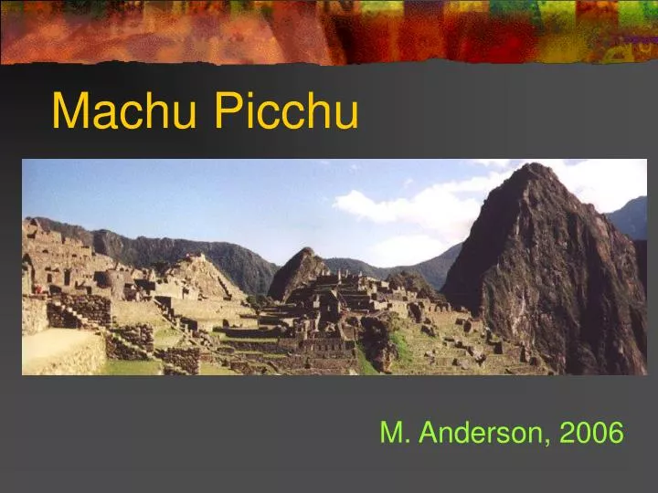
Machu Picchu M. Anderson, 2006 Location The legendary 'Lost City of Machu Picchu‘, located high in the Peruvian Andes, is without a doubt the most important tourist attraction in Peru and one of the world's most impressive archaeological and civil engineering sites. Setting

E N D
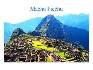
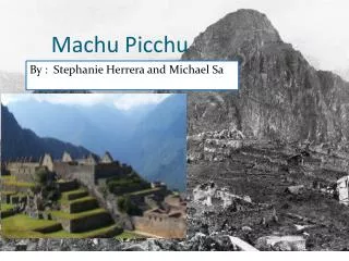
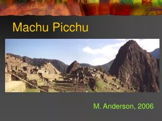
Machu Picchu M. Anderson, 2006
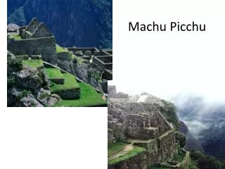
Location • The legendary 'Lost City of Machu Picchu‘, located high in the Peruvian Andes, is without a doubt the most important tourist attraction in Peru and one of the world's most impressive archaeological and civil engineering sites.
Setting • The natural setting on the eastern slope of the Andes encompasses the upper Amazon basin with its rich diversity of species. • The whole archaeological complex covers approximately 5 square km. It is situated in the high jungle. • Its climate is semi-tropical, warm and humid.
Setting • The Ancient City was built by the Incas on the summit of "Machu Picchu" (Old Peak). • It overlooks the deep canyon of the Urubamba River in a semi-tropical area 120 km (75 miles) from the city of Cusco at 7,000 feet above sea level.
Introduction • Machu Picchu was probably the most amazing urban creation of the Incan Empire, with its giant walls, terraces and ramps, which appear as though they have been cut naturally into the rock escarpments. • This site was so well constructed that even after 5 centuries of neglect in the Peruvian jungle, only the thatch and reed roofs are missing.
Machu Picchu The valley below and the zig-zag road leading up to Machu Picchu.
Machu Picchu • Machu Picchu was a complex of temples, palaces and observatories and was believed to be the home of the Inca ruling classes. • From here, high priests made observations and calculations enabling them to chart the heavens - a knowledge which gave them both religious authority and temporal power.
Discovery • Machu Picchu is also one of the Inca's best kept secrets, since they did not leave written records and Spanish chronicles make no mention of the citadel, it remains a mystery. • The City was discovered in 1911 by the American Yale professor, Hiram Bingham.
Discovery • The building style is "late imperial Inca" thought to have been a sanctuary or temple inhabited by high priests and the "Virgins of the Sun" (chosen women). • Excavations revealed that of the 135 skeletons found,109 were women. No signs of post Conquest occupation were unearthed.
Machu Picchu • The original entrance to the complex is on the southwestern side of the citadel at the end of the Inca Trail, a short walk away from "Intipunko " (Sun Gate), the ancient final check point to Machu Picchu. • The present entrance on the southeastern side leads to the agricultural section.
Machu Picchu • The complex can be divided in three distinct sections: Agricultural, Urban, and Religious. • The urban section starts at the wall that separates it from the agricultural area, this group of buildings were constructed on the ridge that descends abruptly to the Urubamba valley.
3 Distinct Sections • View of left side from above. Urban on left, agricultural on far right. Religious upper left.
Religious • Intihuatana (alter) The central plaza that separates the religious from the urban section, has a great rock in the center. The religious section contains splendid architecture and masonry works. One of the most important and enigmatic is probably the Intihuatana shrine, this block of granite was presumably used to make astronomical observations.
Religious • Curved outer temple of the Sun wall. • The "Temple of the Sun", is a circular tower with some of the best stonework of Machu Picchu. • Its base forms a cavern known as the Royal Tomb. • Recent studies show that the actual purpose was for astronomical observance.
Agricultural • The agricultural area consists of a series of terraces and channels that serve dual purpose, as cultivation platforms and as retention walls to avoid erosion.
Residential / Agricultural • Looking up terraces to huts. Some smaller buildings next to large terraces are part of this section and thought to have served as lookout posts.
Urban • In the southern part of this section are found a series of niches carved on rock known as "the jail" with elements that include man size niches, stone rings would have served to hold the prisoner's arms, and underground dungeons.
Urban • The group of refined structures next to "the jail" is known as the "intellectuals' quarters", with tall walls, nooks, and windows built with reddish stone. • They are considered to have been accommodations for the Amautas (high ranked teachers).
Urban One of the buildings has several circular holes carved on the rock floor named the "mortar room" believed to have been used for preparation of dyes.
Urban • The largest urban section in Machu Picchu is located on the north western part. It is reached by a 67 steps staircase and involves a group of buildings not as finely constructed as other parts of the complex.
Huayna Picchu • Huayna Picchu, young peak, is as much a part of the site as the buildings of the citadel, the towering granite peak overlooks Machu Picchu to the North with a steep well preserved original Inca path, well worth the one hour climb for an astounding view of the citadel and the entire valley.
Discovery: MACHU PICCHU • Hiram Bingham found many objects of stone, bronze, ceramic and obsidian, but no gold or silver. • There should have been fabulous riches of these metals comparable to those found at the 'Temple of the Sun' in Cuzco where even the garden contained life-size gold replicas of maize and other plants.
The Fall • The Peruvian scholar Dr Victor Angles Vargas thinks the city became depopulated toward the end of the 15th century before the Spaniards arrived. • Perhaps the city was ravaged by a plague so terrible it was permanently quarantined by the authorities. • What brought this about is one of the deepest enigmas surrounding this sacred site.
Only from the nearby hilltop observatory of Intipunku, can you visualize the full extent of this great engineering and architectural site.
Hydrology • Machu Picchu sits on the top of a mountain ridge so where did the Inca get their water? • In 1976, Ken Wright-the president of Wright Water Engineers, of Denver decided to find out. After all, who better to study the Inca water supply than a water engineer? • Wright spent the next 20 years seeking permission from the Peruvian government to study water engineering at Machu Picchu. • In 1994 he was finally granted permission by the Peruvian government, with political coaxing from President Clinton.
The Questions • Wright soon discovered that the Incas had accumulated a practical knowledge of hydrology, hydraulics, drainage, and foundation engineering. • "They had a perfect site," notes Wright, but its suitability would have been apparent only to a trained engineer. • The slopes were steep; how would buildings be prevented from sliding downhill in a heavy rain? • How would drinking water be made accessible? • And from what source would the water come?
Urban Planning Left side of ruins. The Citadel is a stupendous achievement in urban planning, civil engineering, architecture and stone masonry. • Wright discovered that the Inca must have planned the city carefully before building it. • First, the Inca engineers had to determine the exact location of the spring and whether it would meet the needs of the anticipated population.
Urban Planning. Water Source 1st • The Wright team found that the spring, on a steep mountain slope to the north of Machu Picchu, is fed by a 16.3 ha tributary drainage basin. • After conducting an inflow-outflow evaluation, the team also concluded that the spring draws on drainage from a much larger hydrogeologic catchment basin.
Urban Planning • There was no ‘urban sprawl’ in this mountain retreat of about 1,000 residents; thoughtful consideration was made before the first stone was cut. • The placement of the residence of the Inka (the title of the ruler is used today to name the people) was determined by the location of the mountain spring. • The Inca engineers built the canal at a slope that allowed gravity to pull the water at just the speed they desired for the city’s use, then they used that information to place the royal residence, as well as, the city.
Natural Springs to Canal • A natural spring flows from a geological fault above the city on the steep side of Monte Machu Picchu. • The Inka’s gathered drinkable water from the spring by building a wall in a cut in the mountainside that they had made. • This stone wall was made to let water through, unlike their watertight stone canal into which the spring poured.
Enhancing the Water Source • The Inca enhanced the yield of the spring by building a spring collection system set into the hillside. • The system consists of a stone wall about 14.6 m long and up to 1.4 m high. • Water from the spring seeps through the wall into a rectangular stone trench about 0.8 m wide. • Water from a secondary spring enters the canal about 80 m west of the primary spring. • The Inca also built a 1.5 to 2 m wide terrace to allow easy access for operating and maintaining the spring works. • The spring system still works today, after some minor repairs and cleaning were done.
The System • Special consideration was given to the water system: • a stone canal brought water to the city from a mountain spring; • fountains were built throughout the city for different purposes; • drainage and irrigation systems were on integral parts of the city.
Conveying the Water: The Canal • Before the city could be built, the Inca engineers had to plan how to convey the water from the spring-at an elevation of 2,458 m-to the proposed site on the ridge below. • They decided to build a canal 749 m long with a slope of about 3 percent. • Within the city walls, the water would be made accessible through a series of 16 fountains, the first of which would be reserved for the emperor. • Thus the canal design determined the location of the emperor's residence and the layout of the entire city of Machu Picchu.
The Canal • The Inca built the water supply canal on a relatively steady grade, depending on gravity flow to carry the water from the spring to the city center. • They used cut stones to construct a channel that typically ranged from 10 to 16 cm deep and 10 to 12 cm wide at the bottom. • Wright's team concluded that the nominal design capacity of the channel was about 300 L/min.
Canal • The canal lost little water due to its tight fitting stones and additional clay sealant. • The canal was so well built that today, after 500 years; it would work after minor repairs (mostly clearing old landslides that have filled the canal way). • During the cities occupation the canal was maintained by an Inka access road. • The 749 meter (2,457 foot) canal ended at the first of 16 fountains built in the city.
Canal to the Fountains • The canal descends the mountain slope, enters the city walls, passes through the agricultural sector, then crosses an inner wall into the urban sector, where it feeds a series of 16 fountains known as the stairway of fountains. • The fountains are publicly accessible and partially enclosed by walls that are typically about 1.2 m high, except for the lowest fountain, which is a private fountain for the Temple of the Condor and has higher walls.
The Fountains • At the head of each fountain, a cut stone conduit carries the water to a rectangular spout, which is shaped to create a jet of water suitable for filling an aryballo -a typical Inca clay water jug. • The water collects in a cut stone basin in the floor of the fountain, then enters a circular drain that delivers it to the approach channel for the next fountain.
Fountains • The order of the fountains shows the social hierarchy of the city. • The first fountain is, of course, in front of the residence of the Inka. • The second and third fountains are by temples (used by the religious class). • The third fountain (by the Temple of the Sun-“El Torreon”) can be bypassed with a sort of ‘stone faucet’ by passing the water though an underground stone conduit (‘stone plumbing’). • Fountains 4 to 15 are for public use and the final fountain is by the Temple of the Condor.
Fountains • The fountains were designed for convenience: the water flowed over a stone ‘lip’, making the filling of water jugs easy. • Their drainage system shows the Inka people appreciated water sanitation. • The fountains’ basins drained through stone conduits past the remaining fountains. • This prevented dirty water from flowing into fountains ‘down stream’.
Fountains to drainage • The Inca understood the importance of pure drinking water. • The surface drainage system generally directed agricultural and urban storm water runoff away from the water supply canal. • The Inca apparently did not use the fountains for bathing. • The emperor, for example, had a bathing room with a separate drain, so that bathing water did not reenter the water supply.
Agricultural • View of terraces and rain channels from thatched hut. Perhaps the most visually striking features of the drainage system are the agricultural terraces. Machu Picchu includes 4.9 ha of agricultural terraces, which are held in place by stone retaining walls. In addition to maximizing the land available for farming, the terraces also protected the agricultural sector from erosion.
Terraces • Funerary caretakers hut sits atop the terraces. Wright conducted soil analyses that showed that the Inca constructed the terraces with subsurface drainage in mind. The Inca layered each terrace for efficient drainage, with a layer of stones at the bottom, followed by gravel, sandy material, and topsoil.
The Terraces • The terrace structures also promote good surface drainage. • The slope of the terraces generally directs water toward a system of drainage channels that are integrated with stairways and other structures. • These channels direct the drainage water to a large, east-west main drain that runs through the center of Machu Picchu, separating the agricultural and urban sectors. • Gravity flow carries runoff into the main drain from both sectors, taking it safely away from the city.
Urban Drainage • In the 15th century, the buildings in the urban sector would have been covered with thick thatched roofs. • Because of the density of buildings with impermeable roofs, Wright estimated that about 60% of the water yield from the urban area would have occurred as surface flow.
Plaza Drainage The Inca constructed their plazas in the same way as the terraces, with a deep subsurface layer of rock chips. The plazas received runoff from other areas of Machu Picchu, and the subsurface layer of rocks helped the water to penetrate the ground quickly.
Drainage in the Urban Sector • To deal with the runoff problem, the Inca incorporated about 130 drainage holes into the walls and other structures at Machu Picchu. • They also integrated numerous drainage channels into stairways, walkways, and building interiors to carry runoff to the main drain. • One especially carefully constructed channel drains water away from the entrance to the emperor's residence. • To direct water away from building foundations, the Inca carved channels that would collect the water that dripped from the roofs.
Drainage • Machu Picchu's well-designed drainage infrastructure is one of its most remarkable secrets. It is also one of the keys to its longevity, says Wright: "They built for permanency. They didn't do anything halfway." • At Machu Picchu, drainage was a serious problem. The site rested on top of a ridge with a roughly 50 percent slope and received almost 2,000 mm of rainfall. • For their city to endure, the Inca had to find a way to keep it from sliding down the mountain. • Flooding is controlled by two methods: • 1st a level area of the canal is designed to overflow into a terrace field for irrigation; • 2nd was an overflow outlet by fountain 4 and the main stairway (like slue-ways on modern civil engineering projects).
Sewage System Machu Picchu’s sewage system was built right into the walls of each new building. • This intricate system has as least 127 drainage outlets and is a good representative of Inka engineering. • The Inka’s enjoyed a system superior to their European contemporaries who suffered from diseases caused by open sewers in the streets.
Back-up Water Supply • Wright's team discovered another, previously unknown series of fountains on the eastern side of the ridge, downhill from Machu Picchu. • These fountains received their water not from the canal but from intercepted groundwater drainage. • The Inca had to identify the dry-weather groundwater flow locations to concentrate the flow for use in the fountains. • Adjacent to some of the fountains, an important trail connected Machu Picchu to the Urubamba River in the valley below. • After clearing away the dense forest undergrowth, Wrights’ team restored the water flow to this second series of fountains for probably the first time in 450 years.