Fluvial landforms (1)
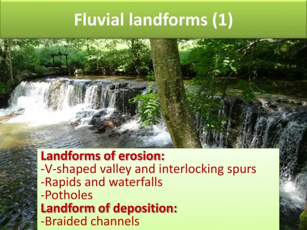
Fluvial landforms (1). Landforms of erosion: V-shaped valley and interlocking spurs Rapids and waterfalls Potholes Landform of deposition: Braided channels. Upper course. Vertical erosion is the dominant process River channel narrow and shallow, often lined with large angular boulders

Fluvial landforms (1)
E N D
Presentation Transcript
Fluvial landforms (1) • Landforms of erosion: • V-shaped valley and interlocking spurs • Rapids and waterfalls • Potholes • Landform of deposition: • Braided channels
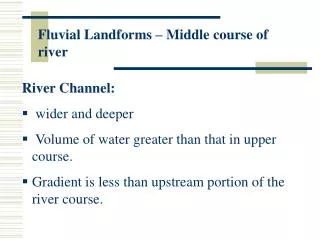
Upper course • Vertical erosion is the dominant process • River channel narrow and shallow, often lined with large angular boulders • Quite steep gradient • Velocity quite low because so much energy used in overcoming friction with the rocky bed and banks of the river
Large boulders from physical weathering and mass movement from the valley side increase friction and reduce velocity. Upper course channel
V-shaped valleys and interlocking spurs The transport of large-calibre sediment may cause intensive vertical erosion which produces a steep-sided V-shaped valley profile.
V- shaped valley and interlocking spurs • Vertical erosion leads to the development of steep-sided, narrow valleys shaped like the letter ‘V’ • The valley sides are steep due to soil and loose rock being washed downhill following periods of heavy rainfall. • The material is then added to the load of the river and transported when the discharge is high. • The river itself is forced to wind its way around hillsides made of hard rock, called interlocking spurs.
Rapids form as a result of the river cutting down rapidly in a localised section of the river. The main characteristics of rapids are distinctly steeper gradients marked by steps in the channel and high turbulence, which is the result of large bed load in the channel or steps.Rapids form:- Over different bands of geology that vary in resistance. Where the river flows from hard to soft rock, the softer rock is eroded relatively rapidly. - Where there is a sudden change in the gradient of the river. - May form downstream of a waterfall. Rapids
Waterfalls are steep steps in the long profile of a river’s course. Waterfalls Thornton Force (Ingleton,UK)
Formation of waterfall and a gorge Watch a short animation which shows the formation of a waterfall and a gorge
Explain the formation of a waterfall. (7) They may be formed by a band of resistant rock occurring on the river bed. The hard rock forms a cap rock, underlain by the soft rock. Differential erosion results and the softer rock is eroded faster than the hard rock, creating a steep gradientin the bed. The increased velocity gained by the water as it falls over the step further increases the rate of erosion of the soft rock. Abrasion and hydraulic action cause undercutting and the formation of a plunge pool at the base of the fall. Eventually the overhanging, more resistant rock collapses due to gravity and the position of the waterfall retreats in an upstream direction. If this process is repeated over time, a gorge-a narrow, steep-sided valley- will be formed downstream of the waterfall.
Case Study: High Force Waterfall Outcrop of resistant, igneous rock, called the Whin Sill overlies weaker sandstone, shale and limestone. Undercutting, collapse and retreat led to the formation of a 22m-high waterfall with a gorge stretching 500m downstream. Questions may include photos and usually ask either for an annotated sketch diagram or a description/explanation of the features of the landform.
Potholes Potholes are cylindrical holes ‘drilled’ into the rock by turbulent high-velocity flow. Vertical eddies may be strong enough to rotate small pebbles, which grind a depression in the rock. The water contains some of the load being carried by the river and this hits the base and sides of the hole to both widen and especially deepen it, smoothing the edges. This is a particular application of the abrasion process, known as pothole drilling. It is most effective at times of high velocity and discharge. As vertical erosion is the dominant process, potholes tend to form well above base level where potential energy is relatively high.The photo shows potholes at low water level. The ‘grinder pebbles can be seen at the bottom.
Explain the formation of channel landforms typically found in the upper course of a river. (15) This question requires both description and explanation of relevant features: waterfalls, rapids and potholes. The formation of at least two channel features must be covered. There may be use of supporting case studies, such as High Force Waterfall on the River Tees.
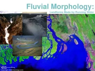
Braiding occurs when the river is forced to split into several channels separated by islands. - River supplied with large loads of sand and gravel transported as bed load. - Small HR as channel very wide in relation to its depth deposition of large material which form temporary bars.Most likely to occur when- River has variable discharge. - Banks formed from sand and gravel, easy to erode. -Common in Alpine rivers with significant snow melts as well as in climates that experience extreme rainfall events: Many arid and semi-arid regions have braided river channels. Temporary bars