Download
1 / 49
500 likes | 728 Vues
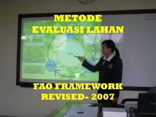
METODE EVALUASI LAHAN FAO FRAMEWORK REVISED 2007. METODE EVALUASI LAHAN FAO-REVISI. BOTTOM-UP KETERLIBATAN STAKEHORLDER. TOP-DOWN. Minat Lingkungan Hidup secara eksplisit. Aktivitas – aktivitas : Pendugaan dampak lingkungan dan Pendugaan risiko lingkungan .

E N D
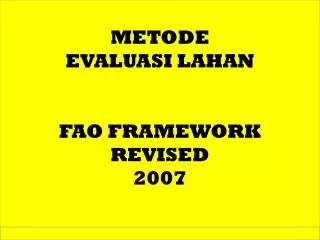
METODE EVALUASI LAHAN FAO FRAMEWORK REVISED 2007
METODE EVALUASI LAHAN FAO-REVISI BOTTOM-UP KETERLIBATAN STAKEHORLDER TOP-DOWN MinatLingkunganHidupsecaraeksplisit Aktivitas –aktivitas: Pendugaandampaklingkungandan Pendugaanrisikolingkungan. Sumber: land evaluation towards a revised framework. Land and water discussion paper 6.. Food and agriculture organization of the united nations. Rome, 2007
PRINSIP DAN PROSEDUR TahappertamadalamEvaluasiLahan (EL) adalahdefinisiTujuanEvaluasi. EL harusmengidentifikasi stakeholder, prosedur EL harusdimulaidari “permintaan” stakeholder ini. Hasil-hasil EL digunakansecaraiteratifdalamdisiplinlainnya, sepertiKontroldegradasilahan, pengembanganwilayah, ygselanjutnyamemberiumpanbalikkepada stakeholder. EL harusmampumenghubungkanmatarantaipengelolaanberkelanjutansumberdayalahan. Kerangkakerja EL mendefinisikanpendekatanpemodelanygdiperlukan, mis. Model Pertanamandan Model PendugaanRisiko. Sumber: land evaluation towards a revised framework. Land and water discussion paper 6.. Food and agriculture organization of the united nations. Rome, 2007
PRINSIP DAN PROSEDUR Evaluasilahan: Produksipangan, pakan danserat Minatkeberlanjutan: Kualitas air Biodiversitas Cadangankarbon Valuasibarangdanjasaekosistemlahan : Barang & jasaEkologis BarangdanjasaEkonomis. Sumber: land evaluation towards a revised framework. Land and water discussion paper 6.. Food and agriculture organization of the united nations. Rome, 2007
PRINSIP DAN PROSEDUR Concerns evolving around social equity have given rise to the view that land use and land resources analysis should consider stakeholders and sectors involved. Land evaluation should therefore aim to be a participatory and cross-sectoral process that allows for review and adaptation to new circumstances with time. In line with sustainable development, the land evaluation process should set performance indicators for socio-cultural and economic values alongside agro-ecological outcomes. Sumber: land evaluation towards a revised framework. Land and water discussion paper 6.. Food and agriculture organization of the united nations. Rome, 2007
PRINSIP DAN PROSEDUR These principles, listed below, envisage assessment for sustainable production of goods and provision of environmental services valued by society, ensuring social equity through stakeholder participation. Land suitability is assessed and classified with respect to specified kinds of use and services. Land evaluation requires a comparison of benefits obtained and the inputs needed on different kinds of land to assess their productive potential and environmental services, and the social equity (sustainable livelihood) of the land use. Land evaluation requires a multi-disciplinary and cross-sectoral approach. Land evaluation should take into account the biophysical, economic, social and political context as well as the environmental concerns. Suitability refers to use on a sustained basis. The sustainability concept includes productivity, social equity and environmental aspects. Land evaluation involves a comparison of more than one kind of use or service. Land evaluation needs to consider the needs, preferences and views of all stakeholders. The scale and level of decision-making needs to be clearly defined prior to the land evaluation process. Sumber: land evaluation towards a revised framework. Land and water discussion paper 6.. Food and agriculture organization of the united nations. Rome, 2007
KesesuaianLahan - Manfaat & JasaLahan The first principle of the 1976 Framework stipulates that land suitability is to be assessed and classified with respect to specified kinds of use. Depending on the objectives of the evaluation, the suitability classes are defined by economic criteria (five classes) or physical criteria (four classes). Physical evaluations are predominantly based on yield reductions, whereas economic evaluations are made on the basis of predicted economic value of the land use. The extended concept of land suitability requires analysis for the services delivered by the land that are valued by society. Such services may include carbon sequestration, biodiversity value and agricultural biodiversity, improved water quality due to reduced sediment transport and biocide use, and landscape value. These services need to be evaluated and monitored by agro-environmental indicators for each specified land use. Sumber: land evaluation towards a revised framework. Land and water discussion paper 6.. Food and agriculture organization of the united nations. Rome, 2007
Pembandingan Output dan Input EvaluasiLahan: Estimasi output barangdanjasa, Metodepengelolaanlahan; Tingkat input ygdiperlukan Valuasijasadanrisikolingkungansecarakuantitatiftidakmudahdilakukan Output lahan yang berupabarang: Hasiltanaman; produksihutan, hasilternak, ikandll. Sumber: land evaluation towards a revised framework. Land and water discussion paper 6.. Food and agriculture organization of the united nations. Rome, 2007
Comparison of benefits obtained and inputs needed Quantitative estimates of crop yields or other types of output are essential to economic evaluation. If the surveyors do not supply them, then the economists will be forced to make estimates. It has been argued that linking soils with agronomic data should be an integral part of soil survey (Young 1973). The surveyor should, for example, make soil observations where agronomic results are available, e.g. at fertilizer trial sites; and when making any soil description, should question farmers on outputs from that land, thus building up a data bank on land performance under given management. Often, this is best carried out by collaboration between surveyor and agronomist or other technical expert. Young, A. 1986. Land evaluation and diagnosis and design: towards a reconciliation of procedures. Soil Survey and Land Evaluation 5: 61–76. Sumber: land evaluation towards a revised framework. Land and water discussion paper 6.. Food and agriculture organization of the united nations. Rome, 2007
Analisis Input-Output The second principle of the 1976 Framework indicates that productive potential is contingent on some kind of input, which might include factors such as labour, external inputs (e.g., fertilizer) or infrastructure (e.g., road construction). Thus evaluation of land for a land use requires a comparison between benefits obtained and inputs needed. The principle of comparing benefits and inputs to assess the productive potential of the land is essentially of an economic nature. In practice, however, the majority of land evaluations have taken quantitative physical land qualities as the basis for comparison. Sumber: land evaluation towards a revised framework. Land and water discussion paper 6.. Food and agriculture organization of the united nations. Rome, 2007
Analisis Input-Output Analisis Input-Output ditujukanuntukmenilai: PpotensiProduksi JasaLingkungan KeadilanSosial (mis. Pembangunan pedesaan). Analisis Input-Output: SecaraBiofisik SecaraSosial-ekonomis Sumber: land evaluation towards a revised framework. Land and water discussion paper 6.. Food and agriculture organization of the united nations. Rome, 2007
Analisis Multi-disiplindanLintas-Sektor PrinsipketigadariMetode FAO 1976 adalahpendekatanmultidisiplinuntukevaluasilahan Prosesevaluasilahanmelibatkanilmu-ilmu: Ilmu –ilmualam (mis. geomorphologi, Ilmu Tanah, Ekologi), Teknologiguna-lahan (mis. Agronomi, Kehutanan, Irigasi, BudidayaTernak), Ilmuekonomi (mis. Agroekonomi) Sosiologi (mis. Pengembanganwilayah, Anthropologi). Sumber: land evaluation towards a revised framework. Land and water discussion paper 6.. Food and agriculture organization of the united nations. Rome, 2007
Analisis Multi-disiplindanLintas-Sektor There is an increasing need to take into account cross-sectoral processes, in view of the recognition that there are competing sectors and inherent groups that have an impact on the land and land resources. A multi-sectoral approach identifies different sectors such as agriculture, industry, tourism and environmental organizations that may have a vested stake in the land and can influence its value. To reach the goal of sustainable development, an integrated approach to sectoral development is required. Sumber: land evaluation towards a revised framework. Land and water discussion paper 6.. Food and agriculture organization of the united nations. Rome, 2007
KonteksdanMinatLingkungan The fourth principle of the 1976 Framework stipulates that land evaluation should be made in terms relevant to the physical, economic and social context of the area concerned. The assumptions underlying land evaluation will differ from one region to another. Evaluations should take into account the biophysical, economic, social and political context as well as environmental concerns in the area where land evaluation will take place. Many of the contextual factors have often remained implicit, but the assumptions made should be explicitly stated to avoid misunderstanding, assist in comparisons between different regions, and facilitate re-evaluation when conditions change. Sumber: land evaluation towards a revised framework. Land and water discussion paper 6.. Food and agriculture organization of the united nations. Rome, 2007
Sustainability includes productivity, social equity and environmental aspects The fifth principle of the 1976 Framework highlights the need for land use to be sustainable in terms of increased productivity without resource depletion. For any proposed form of land use, the probable consequences for the environment should be assessed as accurately as possible and such assessments taken into consideration in determining suitability. Sumber: land evaluation towards a revised framework. Land and water discussion paper 6.. Food and agriculture organization of the united nations. Rome, 2007
Sustainability includes productivity, social equity and environmental aspects proved productivity encompasses the need for quality while ensuring sufficient quantity. Inherently linked to the global concern of sustainability and to the need for a holistic approach is the requirement for monitoring the agro-environment. A revised Framework should recognize the importance of monitoring the agro-environment, take into account problems, including both environmental and socio-economic, arising from the competition among land uses and aim at maintaining the multiple functions of the agro-ecosystems. Sumber: land evaluation towards a revised framework. Land and water discussion paper 6.. Food and agriculture organization of the united nations. Rome, 2007
Comparison of different land uses and services The sixth principle of the 1976 Framework recognizes that there can be more than one single use for land; therefore a comparison of different possible land uses needs to be carried out. A more integrated approach to the issue of different land uses is based on the recognition that different uses and services of the land may be favoured by different stakeholders and by different sectors, and that some uses or services may be mutually exclusive. Sumber: land evaluation towards a revised framework. Land and water discussion paper 6.. Food and agriculture organization of the united nations. Rome, 2007
EvaluasiLahanharusmemperhatikan Stakeholder An important additional principle to the revised principles of the 1976 Framework concerns the stakeholders in the land. It is a prerequisite for effective land evaluation that all stakeholders are adequately considered and consulted. The techniques of participatory appraisal and stakeholder analysis are key tools for conducting a land evaluation with the full involvement of stakeholders. Sumber: land evaluation towards a revised framework. Land and water discussion paper 6.. Food and agriculture organization of the united nations. Rome, 2007
EvaluasiLahan - Semua Stakeholder In principle, participation by stakeholders should take place continuously at all stages of the survey, but this will not usually be possible. In practice, and as an essential minimum, discussion with farmers and other stakeholders can take place at two, possibly three, stages: At the start of an evaluation, as part of Initial Consultations. In development projects, such discussion can be built into the project cycle, and may take place before the terms of reference are finalized. Possibly, at one or more interim stages, when early results show that modifications need to be made to the original proposals. Towards the end of the survey, when provisional results are available, but before they are finalized. All stakeholders should be presented with the draft proposals, and given a clear opportunity to comment upon them. Sumber: land evaluation towards a revised framework. Land and water discussion paper 6.. Food and agriculture organization of the united nations. Rome, 2007
Sekaladan Tingkat Keputusan Another additional principle is that the scale and level of decision-making should be defined prior to land evaluation. Identifying the scale and decision-making level are important not only for selecting the data survey techniques and analysis tools, but also for reporting which stakeholders and sectors have been explicitly taken into account and are primarily addressed in the analysis. The principles and general procedure of land evaluation are scale-independent, but the specific tools and methods should be tuned to the goals, the decision-making level en the envisaged scale. A land evaluation designed to respond to the needs of regional planners might not provide results directly relevant for individual farmers, because their questions and interests are different from those of the planners and because the required scale would be much more detailed. The timeframe of a land evaluation exercise will also depend on the scale and detail required. Sumber: land evaluation towards a revised framework. Land and water discussion paper 6.. Food and agriculture organization of the united nations. Rome, 2007
PROSEDUR EVALUASI LAHAN A schematic representation of proposed land evaluation procedures is presented in Figure 1. In this scheme, the socio-economic components of diagnosis and design form an important contribution. Diagnosis and design is a methodology developed at ICRAF (1983a and b) for identifying the best system of improved land use for given sites, specifically related to agroforestry but also applicable to other land use systems (Young 1985; 1998 p.75). It has essentially the same aim as land evaluation but is stronger in the treatment of social aspects. Since most development projects entail modifications of existing systems, land evaluation can benefit through inclusion of procedures from diagnosis and design to diagnose the problems of the existing systems and design responses or solutions. Also, social analysis could draw upon some of the detailed methods in diagnosis and design. ICRAF 1983a. Guidelines for agroforestry diagnosis and design. ICRAF Working Paper 6, Nairobi, Kenya. ICRAF 1983b. Resources for agroforestry diagnosis and design. ICRAF Working Paper 7, Nairobi, Kenya. Young, A. 1986. Land evaluation and diagnosis and design: towards a reconciliation of procedures. Soil Survey and Land Evaluation 5: 61–76. Young, A. 1998. Land resources: now and for the future. Cambridge University Press, UK. Sumber: land evaluation towards a revised framework. Land and water discussion paper 6.. Food and agriculture organization of the united nations. Rome, 2007
PROSEDUR EVALUASI LAHAN Sumber: land evaluation towards a revised framework. Land and water discussion paper 6.. Food and agriculture organization of the united nations. Rome, 2007
PROSEDUR EVALUASI LAHAN With time, land evaluation has become increasingly integrated with other disciplines. Its basis still lies in the evaluation of the biophysical resources, but economic evaluation gained in importance and social and environmental components were included. There is an urgent need for an integrated approach between the different disciplines. This means that a multidisciplinary team of researchers is involved (or at least informed) in all stages of the land evaluation. A multi-stage approach is presented but at each stage, the knowledge and experience of the stakeholders and the different researchers is included in the considerations and if possible, integrated. Sumber: land evaluation towards a revised framework. Land and water discussion paper 6.. Food and agriculture organization of the united nations. Rome, 2007
KonsultasiAwaldengansemua Stakeholder In the original Framework, the initial consultation started at the level of the planning authorities that initiated the study and the organization that will carry it out. This typical top-down start might have been appropriate in areas with a low population density, but has become outdated and unacceptable in most parts of the world. The initial question for actions related to land evaluation has to come from the land users themselves. Sumber: land evaluation towards a revised framework. Land and water discussion paper 6.. Food and agriculture organization of the united nations. Rome, 2007
KonsultasiAwaldengansemua Stakeholder The active participation of all stakeholders and their representatives in the formulation of land-use objectives and in a dialogue on the procedures of land resource evaluation should ensure that the proposed land uses are socially acceptable to these groups (FAO 1999a). At this critical initial stage in the process, intensive consultations with the stakeholder groups should deal with the implications of possible land-use changes in so far as they may impinge on issues such as rights of access or impose or modify responsibilities for management and conservation. FAO 1999a. The future of our land – Facing the challenge. Guidelines for integrated planning for sustainable management of land resources. FAO, Rome. xiii + 71 p. ISBN 92 5 104366 3. Also CD-ROM incl. related documents: Land and Water Digital Media Series 8. Sumber: land evaluation towards a revised framework. Land and water discussion paper 6.. Food and agriculture organization of the united nations. Rome, 2007
KonsultasiAwaldengansemua Stakeholder At this stage, the following items need to be dealt with: Definition of the objectives in consultation with all the stakeholders; Identification of the constraints of the existing situation; Specification of the data and assumptions on which the land evaluation is to be based; The extent and boundaries of the area to be evaluated; The kinds of land use which appear to be relevant for consideration; The type of suitability classification to be employed; The intensity and scale of the required survey; The phasing of the activities in the evaluation; Planning of the evaluation in consultation with the stakeholders. Sumber: land evaluation towards a revised framework. Land and water discussion paper 6.. Food and agriculture organization of the united nations. Rome, 2007
KonsultasiAwaldengansemua Stakeholder The original Framework indicated two options: A two-stage approach, in which the biophysical aspects are dealt with first, followed by the social and economic aspects; and a parallel approach. The procedures proposed in this chapter follow a parallel approach, where different activities take place simultaneously, conducted by a multidisciplinary team, and interaction and iteration are integral aspects of the process. In cases where a fully parallel approach would not be feasible, a more modular procedure would be recommended. Then, the biophysical aspects of the work would generally precede the social and economic aspects – however, activities i and ii, initial consultation with stakeholders and diagnosis of land use problems, should be done jointly to ensure that the different experts work with the same goals and assumptions. Sumber: land evaluation towards a revised framework. Land and water discussion paper 6.. Food and agriculture organization of the united nations. Rome, 2007
Diagnosis ProblematikLanduse Path P, leading to the box ‘diagnosis of land use problems’, should be taken where it is known that existing land use systems in an area are facing problems, which is likely in many land evaluation exercises, and where one of the objectives of the evaluation is to assist in solving these. Examples are declining soil fertility, overgrazing, fuelwood shortage. There is an input of information on land units (Path N) and from the stakeholders (Path P). Diagnosis is an important stage in the land evaluation. It has an effect on the information needed for social analysis (Path S). Sumber: land evaluation towards a revised framework. Land and water discussion paper 6.. Food and agriculture organization of the united nations. Rome, 2007
IdentifikasiLanduse (LUT) The identification and description of the kinds of land use to be considered is an essential part of the evaluation procedure. Some restrictions to the range of uses relevant for consideration will have been set by the objectives and assumptions. Adatigasituasi yang berbeda: The kinds of land use are specified at the beginning of the evaluation procedure (land utilization type descriptions as in the original Framework; see Glossary). The information derived from the diagnostic analysis (Path Q) may be used for the formulation of existing land utilization types, and procedures derived from the design stage may be used as one means for the formulation of improved land utilization types. The kinds of land use are broadly described at the beginning and subject to modification and adjustment in accordance with the findings of the evaluation procedure. Sumber: land evaluation towards a revised framework. Land and water discussion paper 6.. Food and agriculture organization of the united nations. Rome, 2007
PersyaratanLanduse: Fungsi & Limitasi Persyaratanguna-lahaniniakanmengarahkanevaluasipadakarakterlahan yang relevan , dankemudianmenentukankesesuaianlahanberdasarkanpadakarakter –karakterini. Kalau “guna-lahan” telahdiketahui, makaharusdidefinisikanPersyaratannya, FungsinyadanKeterbatasannya. Where functions of the land other than biomass production are being assessed, such as carbon sequestration or stabilized outflow from catchment areas, a point that requires further consideration is whether the suitability for these functions (related to environment, settlement, economy) can be formulated in terms of requirements –preferably quantitative–, or whether a different approach to the estimation of suitability for such functions would be more practical. Sumber: land evaluation towards a revised framework. Land and water discussion paper 6.. Food and agriculture organization of the united nations. Rome, 2007
DeskripsiSatuanPetaLahan & KualitasLahan These stages correspond to the land resource survey. The objectives of such surveys are to define and delineate boundaries of land mapping units and to determine their land qualities. Most land evaluation studies require physical resource surveys; in some cases sufficient information may be already available. The surveys will generally include a soil or soil-landform survey, and sometimes pasture resource or other ecological surveys, forest inventory, surveys of surface-water or groundwater resources, or road engineering studies. Participatory approaches, in which the insights and information of land users and surveyors are integrated, will provide the most directly relevant results. The success of the integration depends very much on the quality of the base maps. It is necessary to start from accurately identified reference locations, by preference on detailed topographic maps, rectified aerial photos or detailed satellite images. Sumber: land evaluation towards a revised framework. Land and water discussion paper 6.. Food and agriculture organization of the united nations. Rome, 2007
DeskripsiSatuanPetaLahan & KualitasLahan Delineasisatuanpetalahandidasarkanpadakarakterlahanyg paling mudahdiidentifikasi, mis landform, tanahdanvegetasi. However, at the stage of resource survey, the land qualities believed to have significant effects on the types of land use under consideration have already been provisionally identified; consequently, special attention should be given to those qualities during field survey. Mis. Surveiproyekirigasiharusmenilai: 1. Ciri-cirifisikatanah 2. Kualitasdanjumlah air ygtersedia 3. Kondisimukalahan MetodeIrigasi Sumber: land evaluation towards a revised framework. Land and water discussion paper 6.. Food and agriculture organization of the united nations. Rome, 2007
DeskripsiSatuanPetaLahan & KualitasLahan Suitability classes may be defined in terms of land qualities or land characteristics, as defined and illustrated in the original Framework (pp.12–13). From a systems point of view, land qualities are to be preferred, but some studies have found land characteristics simpler for the evaluator and more easily understood by users of the evaluation. Thus, plants respond to the land quality of moisture availability; mean annual rainfall is an important land characteristic affecting this, although by no means the only one. In some cases land qualities and characteristics are closely similar, as where the quality soil salinity is assessed by the characteristic topsoil salt content. Some studies have shown that evaluation for the same land uses carried out using qualities and using characteristics produces very similar results (Sys 1978; Sys et al 1991a, b, 1993). Sys, C., Van Ranst, E. & Debaveye, J. 1991a. Land evaluation. Part 1: Principles in land evaluation and crop production calculations. Agricultural publications 7,1. General Administration of Development Cooperation of Belgium, Brussels. 273 p. Sys, C., Van Ranst, E. & Debaveye, J. 1991b. Land evaluation. Part 2: Methods in land evaluation. Agricultural publications 7,2. General Administration of Development Cooperation of Belgium, Brussels. 247 p. Sys, C., Van Ranst, E. & Debaveye, J. 1993. Land evaluation. Part 3: Crop requirements. Agricultural publications 7,3. General Administration of Development Cooperation of Belgium, Brussels. 199 p. Sumber: land evaluation towards a revised framework. Land and water discussion paper 6.. Food and agriculture organization of the united nations. Rome, 2007
DeskripsiSatuanPetaLahan & KualitasLahan It is preferable to use land qualities wherever possible, since the use of land characteristics often involves hidden assumptions (e.g. if rainfall alone is used to assess moisture availability, an assumption that soils are of similar texture, depth, slope, infiltration rate, etc). Deskripsisatuanpetalahan: Beberapakarakterlahan CampuranKualitaslahandanKarakterlahan Sumber: land evaluation towards a revised framework. Land and water discussion paper 6.. Food and agriculture organization of the united nations. Rome, 2007
DeskripsiSatuanPetaLahan & KualitasLahan The concept of land qualities –assessed by means of land characteristics, as commonly applied to crop and forest production– can be employed equally when assessing environmental services. Contoh: the land quality ‘remoteness’ or ‘isolation’, relevant to assessing suitability for a nature reserve, could be assessed by the land characteristic distance from the nearest road; the land quality ‘Potential water yield’, relevant to assessing suitability for preserving land for rainwater harvesting, could be assessed either directly, by gauged river flow, or where there are no such measurements, by some combination of available data including rainfall, vegetation and soil characteristics. Sumber: land evaluation towards a revised framework. Land and water discussion paper 6.. Food and agriculture organization of the united nations. Rome, 2007
AnalisisSosial-Ekonomi: AnalisisEKonomi Although the fourth principle of the 1976 Framework did emphasize the importance of economic land evaluation, there are hardly any published economic land evaluations. Rossiter (1995) identifies three causes: historical, institutional and practical. Land evaluation is mostly carried out by natural resource specialists with little or no economics training. Institutional barriers may also be significant: natural resource scientists and economists may be located in different organizations or in different sections of the same organization, with little motivation or support for interdisciplinary projects. Many land evaluations were used to attract financial support for development projects, but not to help guide their implementation. Therefore the fact that a recommended land use option might not have been economically feasible is not exposed. Rossiter, D.G. 1995. Economic land evaluation: why and how. Soil Use and Management 11: 132–140. Sumber: land evaluation towards a revised framework. Land and water discussion paper 6.. Food and agriculture organization of the united nations. Rome, 2007
AnalisisSosial-Ekonomi: AnalisisEKonomi The chief obstacle to economic land evaluation is the difficulty of obtaining reliable data on the economics of production and how these are affected by land qualities. The difficulty can be handled in several ways (Rossiter 1995). First, since land evaluation is a strategic rather than tactical planning tool, its predictions do not need to be excessively precise. Second, sensitivity analysis can be used to see how wrong estimates of economic or land data must be before there is a change in predicted land allocation or economic suitability. Third, a variety of techniques can be used to estimate ‘S1’ yields and input levels and how these change with increasing limitations: rural surveys, expert judgement, statistical modelling and simulation modelling. When several different techniques give similar results, it is likely that the economic predictions are close enough for land evaluation purposes. Rossiter, D.G. 1995. Economic land evaluation: why and how. Soil Use and Management 11: 132–140.
AnalisisSosial-Ekonomi: AnalisisEKonomi Evaluasilahansecaraekonomistidakterlalusulit. Menyediakanprediksiyglebihbagusatas “kinerjaLahan” Lebihmencerminkankriteriapengambilankeputusanolehpenggunalahan Sumber: land evaluation towards a revised framework. Land and water discussion paper 6.. Food and agriculture organization of the united nations. Rome, 2007
AnalisisSosial-Ekonomi: AnalisisSosial In the initial and diagnosis stages, the land users are directly involved. In these stages, particular care should be taken to include groups who are not land users in the survey area but who may be affected by proposed land-use changes. For example, communities living further downstream may be affected by developments involving increased water use or changes in land cover. If they have not been involved previously, such groups should be involved in the discussions as soon as it becomes clear that their interests may be affected by such developments. Sumber: land evaluation towards a revised framework. Land and water discussion paper 6.. Food and agriculture organization of the united nations. Rome, 2007
AnalisisSosial-Ekonomi: AnalisisSosial More formal screening of social impacts may be required, particularly in national and sub-national land-use plans where grassroots stakeholder involvement in planning may have been less active. The impact of any changes in land use should be assessed in relation to the following social factors (FAO 1999a): access to land resources (including wild plant and animal products) nutritional status (particularly of vulnerable groups) health status (presence and virulence of endemic diseases) education (opportunities to learn new skills). 1. FAO 1999a. The future of our land – Facing the challenge. Guidelines for integrated planning for sustainable management of land resources. FAO, Rome. xiii + 71 p. ISBN 92 5 104366 3. Also CD-ROM incl. related documents: Land and Water Digital Media Series 8. Sumber: land evaluation towards a revised framework. Land and water discussion paper 6.. Food and agriculture organization of the united nations. Rome, 2007
KomparasiLandusedenganLahan Persyaratan Matching The focal point in the evaluation procedure is where the various data are brought together and compared, the comparison leading to the suitability classification. These data are: the relevant kinds of land use and their requirements the land mapping units and their land qualities, limitations and functions the economic and social conditions. The comparison of land use with land was described in the original Framework and is not repeated here. Sumber: land evaluation towards a revised framework. Land and water discussion paper 6.. Food and agriculture organization of the united nations. Rome, 2007
PendugaanDampak & RisikoLingkungan Pentingnyakeduaanalisispendugaaninitelah lama berkembang. Implementasinya : Pendekataninterdisipliner, Pemodelan spatial dan Pemodelanlingkungan Sumber: land evaluation towards a revised framework. Land and water discussion paper 6.. Food and agriculture organization of the united nations. Rome, 2007
Indikator Agro-Lingkungan Objective and measurable criteria with potential to compare between areas and monitor changes over time are needed to describe the condition and management of land resources and the pressures exerted upon the land (Young 1998). International organizations have initiated programmes on developing measurable and policy-relevant environmental indicators (OECD 1997; UN 1995) to monitor progress in reaching sustainable development, as defined in Agenda 21 (UNCED 1993). The pressure-stateresponse approach (Pieriet al., 1995) provides a framework to develop land quality indicators and to consider and analyse pressures upon land resources, changes in the state of the land and responses by society to these changes, within the context of policy and natural resource management. OECD 1997. Environmental indicators for agriculture. Organisation for Economic Cooperation and Development, Paris. Pieri, C., Dumanski, J., Hamblin, A. & Young, A. 1995. Land Quality Indicators. World Bank Discussion Paper No 315. The World Bank, Washington, DC. UN 1995. Chapter 40: Information for decision-making and Earthwatch. Commission on Sustainable Development, Economic and Social Council E/CN.17/1995/7, February 1995. United Nations, New York. UNCED 1993. Agenda 21: programme of action for sustainable development. UN Conference on Environment and Development. United Nations, New York.
Indikator Agro-Lingkungan Multiple stakeholders are involved in moulding the desirable goal of sustainable natural resource management and each group may find different indicators relevant to their reasons for monitoring change. Integrating these different perspectives, particularly those of local people, into indicators could lead to a better understanding of the processes that cause change (ILEIA 1996; Abbot and Guijt 1998). Another issue is the level of spatial and conceptual aggregation. The design of effective indicators at a continental scale requires a high level of both conceptual and spatial aggregation (Niemeijer 2002), whereas specific and local management interventions may require a larger set of detailed indicators to be developed at a higher resolution. Abbot, J. & Guijt, I. 1998. Changing views on change: Participatory approaches to monitoring the environment. SARL Discussion Paper 2, International Institute for Environment and Development, London. ILEIA 1996. Tracking change: indicators to assess a moving target. ILEIA Newsletter 12 (3): 4–5. ILEIA, The Netherlands. Niemeijer, D. 2002. Developing indicators for environmental policy: data–driven and theory– driven approaches examined by example. Environmental Science and Policy 5: 91–103.
PenelitianAgronomis & Bio-fisik Path R1 and R2 are two research loops. R1 leads to an activity at the end of the description of the land utilization types. The ‘need for research’ is the assessment of the state of knowledge about the proposed land utilization types in the area. A similar research loop may exist for questions related to the biophysical land resource assessment. Some land qualities may be based on properties derived by modelling. In this stage, confrontation with the local knowledge on the natural resources is essential, so the need arises for participatory methods for land resource analysis and for methods and guidelines for integration of participatory methods and biophysical survey. Land users might also possess valuable knowledge on land use requirements and limitations. Over time they may have developed their own local land suitability classes. Sumber: land evaluation towards a revised framework. Land and water discussion paper 6.. Food and agriculture organization of the united nations. Rome, 2007
PenelitianAgronomis & Bio-fisik An important implication is that it takes at least two to three years even for annual cropping systems, and thus prevents the immediate completion of the evaluation. A realistic way to overcome this problem, according to Young (1985), is: Complete the evaluation, using best available estimates of performance where knowledge is insufficient; Note those land utilization types that have potential for improvement through research and also those for which performance data are relatively uncertain; Set up a programme of research into the improvement of land utilization types and assessment of their performance. Results from this research will be fed into the land use planning process in due course. Young, A. 1986. Land evaluation and diagnosis and design: towards a reconciliation of procedures. Soil Survey and Land Evaluation 5: 61–76. Young, A. 1998. Land resources: now and for the future. Cambridge University Press, UK. Sumber: land evaluation towards a revised framework. Land and water discussion paper 6.. Food and agriculture organization of the united nations. Rome, 2007
PenelitianAgronomis & Bio-fisik The dual function of the research may be noted. First, it seeks to improve and optimize land utilization types, e.g. through selection of crop and tree varieties, fertilizers or other aspects of management. Secondly, it determines the performance of the improved systems, thus providing data for revision of the land evaluation. Research loop R2 is related to biophysical research activities. Information collected in the land resource survey feeds other disciplines. An example of a specialized study might be carbon sequestration assessment in soils. The assessment of carbon sequestration involves two phases: measurement of soil carbon stocks and evaluation of changes in carbon storage. Total organic carbon has to be determined at different depths or for one or more horizons, and these data should be transformed into mass of soil organic carbon per unit land area, taking into account the bulk density and stoniness of the soil. The data are then stratified by soil and terrain unit and extrapolated using digitized soil and terrain maps and land-use information (FAO 2001). Changes in carbon storage are estimated on the basis of historical examples and models. Research activities related to local knowledge on the biophysical environment such as soil resources and water conservation also fit in research loop R2. FAO 2001. Soil carbon sequestration for improved land management. World Soil Resources Reports 96. FAO, Rome.
KlasifikasiKesesuaianLahan Proses matching dipadu-serasikandgn : Analisislintassektor; Pendugaandampaklingkungan Pendugaanrisikolingkungan Pemodelanproduksi Analisisindikatorekologis, ekonomi, sosial Klasifikasikesesuaianlahanuntukjenispenggunaantertentu. Sumber: land evaluation towards a revised framework. Land and water discussion paper 6.. Food and agriculture organization of the united nations. Rome, 2007
PenyajianHasilEvaluasi Resulting from the added activities, further types of information appear in the results of the land evaluation. This information, and the proposed course of action which is suggested, should be presented to all stakeholders at any early stage, to allow wide discussion. A practical point is that project and staff time should be allowed for making modifications consequent upon the responses received. Sumber: land evaluation towards a revised framework. Land and water discussion paper 6.. Food and agriculture organization of the united nations. Rome, 2007