Download
1 / 59
590 likes | 686 Vues
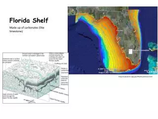
A Three Dimensional Numerical Study of Storm Surges Along the West Florida Coast by Huijun Yang and Robert H. Weisberg College of Marine Science University of South Florida St. Petersburg, Florida. West Florida Shelf Hurricane Surge Simulation Region.

E N D
A Three Dimensional Numerical Study of Storm Surges Along the West Florida CoastbyHuijun YangandRobert H. WeisbergCollege of Marine ScienceUniversity of South FloridaSt. Petersburg, Florida
Sea level elevations as a function of time for a category 2 hurricane moving eastward toward Tampa Bay along storm track E2.
Storm surge at specific locations along the west Florida coast for a category 2 hurricane moving eastward toward Tampa Bay along storm track E2.
Sea level elevations as a function of time for a category 2 hurricane moving eastward toward Naples along storm track E1.
Storm surge at specific locations along the west Florida coast for a category 2 hurricane moving eastward toward Naples along storm track E1.
Sea level elevations as a function of time for a category 2 hurricane moving eastward toward Cedar Key along storm track E3.
Storm surge at specific locations along the west Florida coast for a category 2 hurricane moving eastward toward Cedar Key along storm track E3.
Sea level elevations as a function of time for a category 2 hurricane moving northeast toward Cedar Key along storm track NE1.
Storm surge at specific locations along the west Florida coast for a category 2 hurricane moving northeast toward Cedar Key along storm track NE1.
Sea level elevations as a function of time for a category 2 hurricane moving north toward Apalachicola bay along storm track N1.
Storm surge at specific locations along the west Florida coast for a category 2 hurricane moving north toward Apalachicola Bay along storm track N1.
Sea level elevations as a function of time for a category 2 hurricane moving north toward Steinhatchee along storm track N2.
Storm surge at specific locations along the west Florida coast for a category 2 hurricane moving north toward Steinhatchee along storm track N2.
Sea level elevations as a function of time for a category 2 hurricane moving north toward Tampa Bay along storm track N3.
Storm surge at specific locations along the west Florida coast for a category 2 hurricane moving north toward Tampa Bay along storm track N3.
Sea level elevations as a function of time for a category 4 hurricane moving east toward Tampa Bay along storm track E2.
Storm surge at specific locations along the west Florida coast for a category 4 hurricane moving east toward Tampa Bay along storm track E2.
Sea level elevations as a function of time for a category 4 hurricane moving northeast toward Tampa Bay along storm track NE2.