Download
1 / 1
40 likes | 193 Vues
Abdolali Sharghi Environmental Sciences Research Institute, Shahid Beheshti University, Tehran, Iran. Shahid Beheshti University. Introduction.

E N D
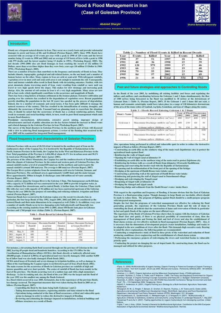
Abdolali Sharghi Environmental Sciences Research Institute, Shahid Beheshti University, Tehran, Iran Shahid Beheshti University Introduction Floods are a frequent natural disaster in Iran. They occur on a yearly basis and provoke substantial damages to assets and losses of life and livelihood (Persian Report, 2007). Since 1990, floods have occurred with an average of 43 events per year (with a peak in 1990 of 120 events and the lowest number being 15 events in 1998 and 2002) and an average of 135 losses of lives (with a peak in 1990 with 979 deaths and the lowest number being 13 deaths in 1993), (Workshop Report, 2005). The last decade (1991-2000) also saw flood damages in Iran reaching the record of 132 million US Dollars, more than seven times higher than they were forty years ago (18 million US Dollar in 1960-1970), (Workshop Report, 2005). There are a number of factors that contribute to the frequency and intensity of floods in Iran. They include climatic, topographic, geological and soil-related factors, on the one hand, and a number of human factors on the other. Many regions in Iran are arid or semi-arid. With infrequent rainfalls, vegetation cover in most arid and semi-arid areas is not enough to maintain the soil. Consequently, short and intense rainfalls often result in flash floods with devastating outcomes. Further, with two great mountain chains traversing much of Iran, water resulting from rainfall or snow melt can travel at very high speeds down the slopes. This makes for slow drainage and increasing peak charge. Also, the amount of soil erosion in Iran is of a very high magnitude. Many areas are now left as bare rocks which significantly contribute to the occurrence and magnitude of floods. There has been a long history of human settlement in the Iranian plateau. Extensive cultivation and grazing over the centuries has resulted in the degradation of vegetation cover. Recent population growth (doubling the population in the last 30 years) has speeded up the process of degradation. Indeed, due to a number of economic and social issues, it has been quite difficult to manage the natural resources of the country. This has resulted in the intensification of erosion, droughts, and ultimately the occurrence of floods. Unsound land use planning tends to exacerbate the situation. Also, it should be noted that the occurrence of floods has a cyclical reinforcing pattern. Floods result in economic and social hardship which, in turn, result in poor flood management which ends in more flood disasters. Floodplain encroachment, deforestation, extensive gravel mining, improper design of infrastructures and lack of public education are the key factors behind the increase in flood events and related damages in the Golestan Province in Iran (Workshop Report, 2005). The survey of the flood disasters in Golestan Province in the northern part of Iran will discussed with a view to achieving flood management systems. A review of the flooding that occurred in the year 2005 will be examined for integrated flood management. Flood & Flood Management in Iran(Case of Golestan Province) Past and future strategies and approaches to Controlling floods In the floods of the year 2005, by mobilizing all existing facilities and forces and regulating the inflows and outflows and coordinating between the Golestan 1 and 2 dams simultaneously, the flow of 1500 m3/sec being forecasted in the flood was modified to 30 m3/sec at the downstream of Golesant Dam 1 (Table 3), (Persian Report, 2007). If the Golesant 1 and 2 dams did not exist, a human and economic catastrophe would have taken place in a range of 120 kilometers downstream of the area of the dams (cities of Gonbad, Aq Qola, Gomishan, and tens of villages along the route). Also, operations being performed in critical and vulnerable spots in order to reduce the destructive impacts of flood as follows (Persian Report, 2007): • Constructing an earth dike on the southern wing of the main road (Injehbroon city) to protect the agricultural lands against flood • Reinforcing the walls of Alagol canal • Opening the wall of Alagol canal at kilometer 19 • Establishing an earth dike on the northern wing of the main road to protect Injebroon city • Reinforcing the broken walls as a result of floods from kilometer 18 towards Dashlibroon • Repairing and renovating the border road with the Republic of Turkmenistan • Re-opening and de-sedimentation of the front part of the opening of the bridges • Dredging at the upstream of Dashli Broon water intake canal • Constructing a protecting wall at the upstream of Dashli Broon water intake • Reinforcing and protecting the wall of Alagol canal in Daneshmand village • Dredging and redeveloping the Tongeli canal • Reopening of Alagol walls at kilometer 34 • Dredging the Almagol and Ajigol canals • Removing sludge and sediments from the Dashli Broon's water- intake floors With regard to the repetition and frequency of flooding, it became obvious that the East of Golestan Province is a flood-generating region. Though damages in large floods are inevitable, efforts should be made to reduce them. The program of fighting against flood should be a multi-purpose program with integrated management. Despite the fact that the programs of watershed management are effective for reducing the flood generating grounds, the experience of the Golestan Province floods and the role of dams in controlling the flood, all indicate that the construction of dams and reservation of floods in particular in fast and quick floods of the region are the most efficient ways. The experience of the floods of Golestan Province shows that, in regions with the features of Golestan type flood (fast and quick), if there is no physical possibility of construction of dam, then the management of flood plains and freeing the limit and bed of rivers and also the establishment of flood alarm systems are two effective methods in flood management (Persian Report, 2007). Also, it is necessary that the dimensions of development projects (water installations, buildings and roads) to be adapted to the new conditions of rivers after the flood. This demands high executive costs. Bearing in mind the above explanations, the following points are recommended: • Conducting a comprehensive study of flood in three pivots of the watershed and reduction of flood producing conditions, rivers engineering and the establishment of a flood alarm system • Performing the emergency projects of redeveloping the rivers and watershed basins in vulnerable priority spots • Conducting the project on changing the use of sloped lands. By constructing dams, the flood can be managed and utilized for other purposes. Flood frequency in and characteristics of Golestan Province Golestan Province with an area of 20,311.6 km² is located in the northern part of Iran on the southeastern shore of the Caspian Sea. It is bordered by the Republic of Turkmenistan in the North, Semnan Province in the South, the Caspian Sea in the West and Khorasan Province in the East. Total population of the Province is 1,426,288 of whom 41.3% live in urban areas and 58.2% in rural areas (Persian Report, 2007; Inter-Agency 2001). The presence of the Alborz Mountains, the Caspian Sea and the southern deserts of Turkmenistan affect the climate of Golestan Province. In the central and western parts of Golestan Province, the annual rainfall reaches a level of around 850 mm/year. In the northern and eastern parts the annual rainfall is around 200 mm/year. The average is 408 mm/year (Persian Report, 2007). The Gorgan River system originates from the mountainous arid area in Golestan, Semnan, and Khorasan Provinces. The catchment area is approximately 12,600¬km2 and the main Gorgan River approximately 350km in length. It discharges some 448 million m3 of water annually (Persian Report, 2007). Almost, midway along the Gorgan River is the Golestan 1 Dam. This homogeneous earth-fill dam with a capacity of 72 million m3 was constructed in the year 2000 to provide irrigation water, to reduce sediment flow downstream, and to control floods. A further dam, the Golestan 2 Dam (earth fills with clay core) with capacity of 36 million m3, has been constructed upstream of the Golestan 1 Dam in the year 2004 for the purpose of controlling and reducing sediment, irrigation and flood control (Persian Report, 2007). Numerous floods have occurred in the Golestan region over the recent two decades but, in particular, the four large floods of May 1992, August 2001, 2002 and 2005 are considered as the featured floods and their main dimensions to be compared as well (Table 1). In addition, every year a number of smaller floods occur in less damaging scales both physically and financially too. According to the existing statistics from 1991 to 2005, about 550 floods took place in Golestan Province and 1,760 people were victims (Table 2), (Persian Report, 2007). For instance, a devastating flash flood occurred through out the province of Golestan in the year 2002, leaving 49 people dead and hundreds homeless. According to the UN Office for the Coordination of Humanitarian Affairs (OCHA), this flood, directly or indirectly affected some 200,000 people. A total of 4,300 ha of agricultural land were heavily damaged, while another 8,000 ha of fallow land was also badly damaged (Flash floods 2002). OCHA noted losses of livestock and severe damage to irrigation facilities, as well as damage to 10km of the road linking the Caspian region to northwestern part of Iran (Flash floods 2002). The main reasons for the occurrence of floods in Golestan province are rainfalls of high and intense quantities and over short periods. The center of rainfall of floods has been mainly in the East of the province. The floods occurring were of a sudden type and with a high momentary discharge. As for its ranking and, size, the flood of the year 2001 was the largest and the flood of the year 1992 was the smallest one among the floods featured. In a flood which occurred in year 2005, fortunately, due to the experiences of the previous floods, less damage occurred. The important measures that were taken during the flood in 2005 are as follows (Persian Report, 2007): - Controlling the flood by the dams being built (Golestan 1 and 2) - Taking documentation measures, registering statistics and data related to the flood - Operations being conducted at the time of flood occurrence, critical and vulnerable spots prone to damage in order to reduce the destructive impacts of flooding - Reviewing and estimating the damages imposed on installations, technical buildings and offshore structures as a result of floods References • Florio, G. (2005) Multifunctionality of organic farming. Organic Farming in Poland as Example of Organic Farming in CEE Countries - from farm to plate", 25-29 July 2005, Warsaw and Culavia - Pomerania, ENAOS 2005 - 4th ENAOS Summer Meeting. • Jiménez, J. J. (2007). Organic Agriculture and the Millennium Development Goals. IFOAM publication • Lampkin, Nicholas, C. Foster, S. Padel, and P. Midmore. (1999). The Policy and Regulatory Environment for Organic Farming in Europe. In Organic Farming in Europe: Economics and Policy.Vol. 2, Stuttgart- Hohenheim University. • Koocheki, A. (2004). Organic farming in Iran. 6th IFOAM-Asia Scientific Conference "Benign Environment and Safe Food", 7th – 11th September 2004. Yangpyung / Korea • Nijhoff, P., Andersson, A. (2001). Organic Farming as a Strategy for a Multi-functional Agriculture. Naturradet, København. • Rosegrant, M. W., C. Ringler, T. Benson, D. Xinshen, D. Resnick, Thurlow, J., M. Torero and D. Orden (2005). Agriculture and achieving the Millennium Development Goals. World Bank. Agriculture and Rural Development Department. International Food Policy Research Institute (IFPRI), Washington, D.C. 93 pages. • Van Huylenbroeck, G., Vandermeulen, V., Mettepenningen, E. & Verspecht, A. (2007). Multifunctionality of Agriculture: A Review of Definitions, Evidence and Instruments. Living Reviews in Landscape Research, 1. Maj 2007. • Vossenaar R and Jha V. (2007). Trading opportunities for organic food products from developing countries. United Nations. • Yrjola, T. and J. Kola,. (2004). Society’s Demand for Multifunctional Agriculture. Contribution to the 90th European Association of Agricultural Economists Seminar: ‘Multifunctional Agriculture’, Rennes.