Download
1 / 1
10 likes | 143 Vues
Inter-Calibration of NPP-S CrIS with VIIRS: CrIS Geolocation Assessment. VIIRS Pixels. Satellite Direction. Likun Wang 1 , Denis Tremblay 2 , Yong Han 3 , Fuzhong Weng 3 , Mitch Goldberg 4

E N D
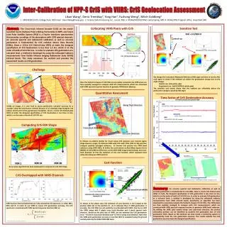
Inter-Calibration of NPP-S CrISwith VIIRS: CrISGeolocation Assessment VIIRS Pixels Satellite Direction Likun Wang1, Denis Tremblay2, Yong Han3, Fuzhong Weng3, Mitch Goldberg4 1. UMD/ESSIC/CICS, College Park, MD Email : Likun.Wang@noaa.gov; 2. Science Data Processing Inc., Laurel, MD;3. NOAA/NESDIS/STAR, Camp Spring, MD; 4. NOAA/JPSS Program office, Greenbelt, MD CrIS FOV footprint VIIRS Scan Direction CrIS FOV Spatial Response Abstract: The Cross-track Infrared Sounder (CrIS) on the newly-launched Suomi National Polar-orbiting Partnership (S-NPP) and future Joint Polar Satellite System (JPSS) is a Fourier transform spectrometer that provides soundings of the atmosphere with 1305 spectral channels. An accurate spectral and radiometric calibration as well as accurate geolocation is fundamental for CrIS radiance Sensor Data Records (SDRs). Given a 14-km CrIS field-of-view (FOV) at nadir, the designed specification of CrIS Geolocation is less than 1.5 km, which is on the order of tenth of CrIS FOV size. In order to evaluate CrIS geolocation at a sub-pixel level, a method is developed by using the collocated radiance measurements from Visible Infrared Imaging Radiometer Suite (VIIRS) infrared bands. This study overviews the method and provides the assessment results on CrIS geolocation. Collocating VIIRS Pixels with CrIS Sensitive Test CrIS Scan Direction 50% Roll +3.0/824.0 FOR 14 FOR 30 FOR 1 Control run Shift Shift distance for CrIS FOV 5 along FOR Challenge We change the Instrument Alignment Reference (IAR) angle and then re-run the ADL code again to check if the method can detect the geolocation change due to the angle change. Control run: (roll, pitch, yaw) Experiment run : (roll+3.0/824.0, pitch, yaw) The sensitive test clearly shows that the method can effectively detect the geolocation changes caused by IAR angel. Once the footprint shapes of CrIS FOVs are accurately computed, the VIIRS pixels are then spatially averaged to compare with CrIS measurements, which are convolved with VIIRS spectral response function to generate VIIRS band radiances. Quantitative Assessment Time Series of CrISGeolocation Accuracy Along Track Direction Unlike an imager, it is very hard to assess geolocation sub-pixel accuracy for a sounder using the land feature method because of 1) relatively large footprint size (above 10 km) and 2) the gap between footprints. Given a 14-km CrIS field-of-view (FOV) at nadir, the designed specification of CrIS Geolocation is less than 1.5 km, which is on the order of tenth of CrIS FOV size. 10/16/2012, Mx6.3 geolocation code error fixed 11/22-12/11/2012 VIIRS Geolocation Error 10/23/2012, EP V35 loaded Computing CrIS FOV Shape Cross-track Direction CrIS Scan Direction 1) Choose un-uniform (better for cloud scene) CrIS granules over tropical region (large dynamic range); 2) Collocate VIIRS with CrIS nadir FOVs (FOR 13-16) and then compute spatially averaged radiances; 3) Convert CrIS spectra into VIIRS band radiances using VIIRS SRFs); 4) Define the cost function as Root Mean Square Errors (RMSE) of CrIS-VIIRS BT difference; and 5) Shift VIIRS image toward along- and cross- track direction to find the minimum of the cost function, which represent best collocation between VIIRS and CrIS. IDPS MX6.3 IDPS MX6.2 Cost Function An accurate algorithm has been developed to compute the CrIS FOV shape. IDPS MX6.2 4.5 km geolocation error error CrIS Overlapped with VIIRS Channels Original Collocation at (0, 0) CrIS image Image differences (CrIS – VIIRS) before and after a coding error fix Summary:An accurate spectral and radiometric calibration as well as accurate geolocation is fundamental for CrIS SDRs. Given a 14-km CrIS field-of-view (FOV) at nadir, the designed specification of CrIS geolocation is less than 1.5 km, which is on the order of tenth of CrIS FOV size. In order to evaluate CrIS geolocation at a sub-pixel level, a method is developed by using the collocated radiance measurements from VIIRS infrared bands. Specifically, an algorithm has been developed to accurately compute the footprint shapes of CrIS FOVs. The VIIRS pixels are then spatially averaged to compare with CrIS measurements, which are convolved with VIIRS spectral response function to generate VIIRS band radiances. By shifting the VIIRS pixel toward along- and cross-track direction, the perfect collocation position can be identified to quantify the geolocation bias of CrIS geolocation FOVs. Based on this method, we have create a monitoring system to automatically track the CrIS geolocation accuracy. The results indicate the CrIS geolocation accuracy meet the designed specification. Scatter plot of CrIS and VIIRS BTs Collocation after shift at minimum of cost function (5, -4) As shown in the above case, the minimum of cost function is not located at the position (0,0) but at the position (5, -4). It indicates that, if VIIRS geolocation is accurate, the CrIS FOVs are not perfectly co-collocated with VIIRS. One has to shift the VIIRS image with 5 pixels cross track direction and 4 pixels against track direction. Based on the pixel size of VIIRS, we can estimate the CrIS geolocation error: ~3.5 km in cross track direction and ~2.7 km in along track direction. Note that the VIIRS pixel geolocation accuracy is less than 80.0 m evaluated using the ground control points by the NASA VIIRS SDR team. VIIRS has four thermal bands that are fully covered by CrIS spectrum, i.e. M13, M15, M16 and I5. In order to use VIIRS to assess CrIS geolocation accuracy, the CrIS spectrum is convolved with VIIRS spectral response function (SRF) as: W-62 NOAA 2013 Satellite Conference