Download
1 / 24
240 likes | 276 Vues
Learn about key weather elements like temperature, wind, humidity & fronts, and how they affect climate. Explore weather maps and symbols, pressure systems, and the impact of temperature changes. Understand different types of fronts and their effects on weather conditions.

E N D
We describe weather in terms of: temperature wind patterns humidity clouds visibility pressure precipitation sunlight/UV • If we observe these weather elements at an instance in time, then we obtain a measure of the weather • If we measure these weather elements over many years, then we obtain the “climate” of the region. • Therefore: • climate represents an average of daily weather over a long period of time • Weather is the instantaneous condition of the atmosphere. We “feel” weather as the heat we feel, the “weight” of the air we breathe.
“Climate is what we expect” “Weather is what we get”
Pressure and Wind • Atmospheric pressure impacts every aspect of weather although we do not easily recognize differences in pressure. • Air moves from high pressure to low pressure → wind • Air tends to rise in regions of low pressure and sink in regions of high pressure • Pressure Units: mb, hPa, inches Hg, mm Hg • Wind Units: m/s, mph, km/h, kts
Temperature • - tends to change gradually in horizontal or vertical directions • also changes with time for the same weather system → diurnal cycle • the only place there are rapid changes in temperature is in the vicinity of fronts • Units:- °C, °F, K
Moisture: water vapor • - Two common ways to express the amount of water vapor in the air • - Relative Humidity:- is the amount of water vapor in the air relative to the maximum amount that could be present in the air. Units: % • Dew Point Temperature:- • Td > 15°C is humid. • Td > 20°C is very uncomfortable. • Td < 5°C is dry.
Surface Map: Cold air Cold air Cold air H L Warm air Warm air Warm air Pressure Systems: low pressure Fronts: high pressure Cold front Warm front Stationary front
Upper-level Maps: 500 mb (hPa) (5 – 6 km or 16000 – 19000 ft)
Upper-level Maps: 300 mb (hPa) (9 – 10 km or 30,000 – 33,000 ft)
CH ff 34CM247 CH VV ppa dd TTCMPPP 30CLNh WRt VVwwppa N h RR TdTdCLNh WRt h RR Weather Map Symbols Ref:- pg 525, Appendix C, Aguado and Burt N – total cloud cover dd – wind direction ff – wind speed (kts) ww – present weather PPP – barometric pressure (hPa) (add a 9 or 10 and place a decimal point to the left of last number) TT– air temperature in °F TdTd - dewpoint temperature in °F Z (UTC) = MST + 7 i.e., 0000 UTC = 5:00 pm MDT 1200 UTC = 5:00 am MDT
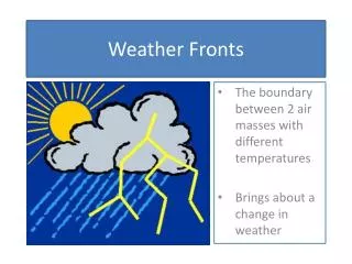
Some basics of Frontal Systems (Chapter 9) • Fronts are boundaries that separate air masses with differing temperature and other characteristics. 2. Often represent boundaries between polar and tropical air - marked by sharp temperature changes over a relatively short distance. • Cold air is typically more dense than warm air → no mixing. Instead, the denser air forces the warmer air upward. 4. This lifting of air upward can cause cloud formation and precipitation. 5. Fronts are marked by wind shifts. 6. Fronts are marked by pressure and pressure changes.
Cooler air Cold air Warm air Cold air Cold air Cold air Warm air Warm air Warm air Types of fronts: Occluded front Fronts: Stationary front Cold front Warm front
Cold air Warm air (relatively) Cold air advection Cold air 1 -5°C 0°C 5°C 2 -25°C -2°C 3°C Warm air 3 -28°C -12°C -5°C Cold Fronts Cold fronts occur when a cold air mass “catches up” with a warm, generally unstable, air mass. St. Louis Day Minneapolis Birmingham
Cold Fronts The cold air mass moves in a different direction (W through N) than the warm air mass ( SW through S). It is also moving faster. The cold air catches up with the warm air and it… 1. pushes the warm, unstable air up because the cold air is denser 2. the cold air has a steep slope, because friction causes the lowest winds to slow down compared with winds higher up 3. unstable rising air mass produces cumulo-type (thunderstorm) clouds • - The thunderstorms can produce very intense precipitation. • They only form right along the frontal boundary, • the fast movement of these fronts means that the precipitation is usually of short duration and clearing skies will soon follow.
South-southwesterly Gusty, shifting West-northwesterly Warm Sudden drop Steadily dropping falling steadily Minimum, then sharp rise Rising steadily Increasing cumulus-type clouds Strong cumulus clouds Often cumulus Short period of showers Heavy showers of rain or snow, sometimes with hail, thunder, and lightening Decreasing intensity, then clearing High: remains steady Sharp drop lowering So what would our observer on the ground expect to see and feel with the passage of a “classic” cold front? Weather element Before Passing While Passing After Passing Winds Temperature Pressure Clouds Precipitation Dew Point
Warm air advection Cold air Warm air Warm Fronts Warm fronts occur when a warm, stable air mass “catches up” with a colder air mass. Warm air Cold air (relatively)
The warm air is moving faster than the cold air. The warm air is less dense than the cold air The warm air “runs up” along the cold air boundary, which is not as steep as in the cold front case (over-running). There are three consequences of this. 3. The precipitation out of this stratiform type cloud tends to be light and continuous, but owing to the large horizontal area of the cloud, and slow movement of these kinds of fronts, the rain can persist for days. 2. The warm air is stable and so it doesn’t form cumulo-type clouds as in the cold front case. Instead, as it is forced to rise, it condenses gradually forming a series of stratiform clouds, in a broad area. 1. The clouds and precipitation form well ahead of the surface front.
South-southeasterly variable south-southwesterly Cool – cold slowly warming Steady rise Warmer, then steady Usually falling Leveling off Slight rise, followed by fall Ci, Cs, As, Ns, St, fog Stratus-type clouds Clearing with scattered Sc Light-to-moderate rain, snow, sleet, or drizzle Drizzle or none Usually none, sometimes light rain or showers Steady rise steady Rise, then steady So what would our observer on the ground expect to see and feel with the passage of a “classic” warm front? Weather element Before Passing While Passing After Passing Winds Temperature Pressure Clouds Precipitation Dew Point
No air advection Cold air Warm air Stationary Fronts Stationary fronts occur when the front stalls. The structure is the same as in other fronts, with the front sloping over the cold air mass. There is no air movement across the frontal boundary, thus, there is no real weather.
Occlusion refers to “closure”. In this case, a faster moving cold front closes with the warm front. Occluded Fronts Are associated with midlatitude cyclones that have both a cold front and a warm front associated with them.
Because at the surface, the cold air mass is now “catching up” with a cooler air mass rather than a warm air mass the temperature change observed at the surface is not as dramatic. As the cold front reaches the warm front, (and thus the cooler air in front of the warm front), the warm air mass is separated from the surface.
An additional change is that now the warm, unstable air is no longer being strongly lifted by the cold front. The cooler air that has replaced the warm air at the surface is not unstable. Thus, where the occlusion has occurred, only stable stratiform cloud develops accompanied by light but persistent rain similar to the warm front.
L Cooler air Cold air Warm air Occluded front Cold air Cold air Cold air Warm air Warm air Warm air Summary:- Types of fronts: Fronts: Stationary front Cold front Warm front