Download

1 / 11
110 likes | 278 Vues
This is an audio-enhanced PowerPoint presentation. To hear the audio, please open this presentation in “Slide Show” view. Understanding the Flood Risk Tools. Reducing Risk and Building Resilient Communities. Flood Risk Tools for Watersheds.

E N D
This is an audio-enhanced PowerPoint presentation. To hear the audio, please open this presentation in “Slide Show” view.
Understanding the Flood Risk Tools Reducing Risk and Building Resilient Communities
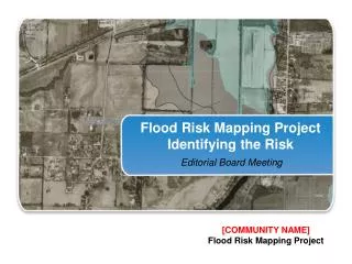
Flood Risk Tools for Watersheds • Flood Risk Tools will be prepared for all communities within a Discovery Watershed: • Flood Risk Report • Flood Risk Map • Flood Risk Assessment • Flood Risk Database
Flood Risk Report (FRR) • Provides summary of flood risk within watershed or project area • Parallels the Flood Insurance Study (FIS) • Includes maps, data, and risk assessment information that may be included in the hazard mitigation plan • Provides risk assessment on both the community and watershed level • Useful for risk communication and outreach
Flood Risk Map (FRM) • Visually depicts areas with the greatest flood risk • Provides specific areas of focus • Emphasizes risk reduction activities that may impact the watershed • Depicts interrelation of flooding issues across jurisdictional borders
Flood Risk Assessment Improves ability to identify areas requiring higher building code requirements or use of flood resilient designs and construction materials Identifies areas of higher flood risk by census block Provides valuable data for mitigation plan’s vulnerability assessment Supports disaster recovery planning by showing areas of highest expected damages http://www.fema.gov/hazus-training
Flood Risk Assessment Estimates value of potential future flood losses to existing structures Improves ability to identify and prioritize effective mitigation actions Supports mitigation plan updates and disaster recovery planning through improved risk quantification Provides valuable data for mitigation plan’s vulnerability assessment Flood Risk Assessment Data
Flood Risk Database • Primary source to access information collected and developed during the flood risk assessment process • Parallels the Flood Insurance Rate Map database • Project-level database • Requires GIS software to fully utilize
Risk MAP Non-Regulatory Products and Hazard Mitigation Planning • FEMA encourages local governments to develop and continually refine Hazard Mitigation Plans • To increase public and political support and commitment for mitigation • To be eligible for Hazard Mitigation Assistance grants • Use Risk MAP tools to update your Hazard Mitigation Plan and build a more Resilient community!
Additional Information for Community Outreach • Risk Communications Guidebook for Local Officials - http://www.riskmap6.com/guidebook.aspx • Fact Sheets • Web-based Key Messages for local officials – http://riskmap2go.riskmap6.com • www.riskmap6.com