Download
1 / 22
220 likes | 387 Vues
In-Situ Data Archiving Center at NCAR (National Center for Atmospheric Research) of USA. Model Output Data Archiving Center at the World Data Center for Climate, Max-Planck Institute for Meteorology of Germany. Data Integrating/Archiving Center at University of Tokyo and JAXA of Japan.

E N D
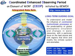
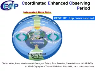
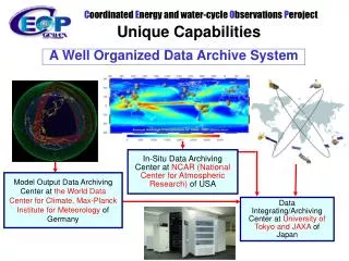
In-Situ Data Archiving Center at NCAR (National Center for Atmospheric Research) of USA Model Output Data Archiving Center at the World Data Center for Climate,Max-Planck Institute for Meteorology of Germany Data Integrating/Archiving Center at University of Tokyo and JAXA of Japan Coordinated Energy and water-cycle Observations Peroject Unique Capabilities A Well Organized Data Archive System
GrADS/ DODS for Subsets GrADS/ DDDS for Subsets Distributed Integration Services UCAR Computing Power In-situ model In-situ model In-situ model Centralized Integration Services In-situ In-situ In-situ model In-situ model http://jaxa.ceos.org/wtf_ceop/ MPI GrADS/ DODS for Subsets model http://monsoon.t.u-tokyo.ac.jp/ceop-dc/ceop-dc_top.htm satellite satellite satellite satellite UT/JAXA Computing Power satellite satellite satellite Coordinated Energy and water-cycle Observations Project Data ManagementDistributed- and Centralized- Data Integration Functions
http://www.eol.ucar.edu/ projects/ceop/dm/ INTEGRATED IN-SITU SATELLITE MODEL
CEOP Metadata Design Meeting University of Tokyo, 1-2 November 2004 • Based on ISO 19115 Metadata Standards • Design for Finding and Integrating data
Web-based Data Archiving & Integration System Observation Data Meta Data Meta Data Meta Data Meta Data Meta Data Meta Data Data Provider (Observer) Data Archiving Data Upload +(part of )Meta Data Data Quality Control Process Input Meta Data Upload Basic Information Meta Data Registration Quality Control Observation Data Observation Point Inf., Contact Person Inf.,…… Post-QC Observation Data Data Integration Data Integration and Analysis System (DA-09-02a) Search IF Data Download Document Generator Visualization System • Search with Metadata • Data Download • Document Generation from Meta Data • Data Visualization • ・・ User
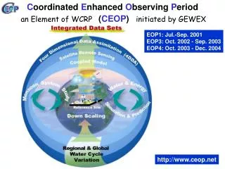
GrADS/ DODS for Subsets GrADS/ DDDS for Subsets Distributed Integration Services UCAR Computing Power In-situ model In-situ model In-situ model Centralized Integration Services In-situ In-situ In-situ model In-situ model http://jaxa.ceos.org/wtf_ceop/ MPI GrADS/ DODS for Subsets model http://monsoon.t.u-tokyo.ac.jp/ceop-dc/ceop-dc_top.htm satellite satellite satellite satellite UT/JAXA Computing Power satellite satellite satellite Coordinated Energy and water-cycle Observations Project Data ManagementDistributed- and Centralized- Data Integration Functions
Data sources • Data location • Standalone physical location • Distributed sites reference by links • Data types • Model output data • Insitu data • Satellite data • Services • Metadata keyword search • Data value search • File format translation • Reprojection • Regridding • Data Interpolation Integrated datasets Multiple files from individual member datasets Intercomparison Of Integrated Datasets Spatial Temporal rectification Spatial Subsetting WTF-CEOPDistributed Data Integration Services Spatial and TemporalData Integration -In-situ, MOLTS, Satellite, Model Output 17
WTF-CEOP: Phase 1 Prototype Web Browser • Users can access; • The data located in distributed archive centers • The data which is temporally and geospatially coordinated JAXA Prototype: “Distributed Data Integration Prototype System for CEOP ” CSDIC Archive [Satellite] (Japan) NCAR Archive [In-situ] (U.S.) Live Access Server (LAS) Ferret MPI Archive [MOLTS, Model Output] (Germany) WCS Server (satellite data) NASA Bridge CEOP Data Archives OPeNDAPInterface Custom Interface NASA Prototype: A bridge between DODS formatted data requests and OGC WCS servers 18
JAXA Prototype: Phase 1 Status= Available Data = • (i)Satellite Data • 250 km x 250 km subset scenes, regridded to Lat/Lon grid, • centered over the 35 in-situ data sites • Band selection, period selection and • download multiple scenes available • (ii) In situData • Four types of CEOP in-situ data from 35 Reference Sites • Surface (19 variables), Tower (9 variables), • Soil (temperature, moisture), • Flux (Sensible Heat, Latent Heat, CO2, Soil Heat Flux) • Download of QC flags available • (iii) Model Output Data • NWP – Numerical Weather Prediction data • MOLTS – Model Output Location Time Series • (time series at model grid point nearest center of in-situ data sites) • Gridded Model Output – 2D/3D time series. 19
JAXA Prototype: Phase 1 Status= Main Functions = • Accessdata from distributed archive sites • Select • data type • location (Reference Site, Station name) • variable name • height or depth • time range (start time / stop time) • “See the data” • plot • view values on the screen • Download • NetCDF • Ascii • Spreadsheet format • Registration (to satisfy CEOP data policy) 20
Top Page JAXA Prototype: Phase 1 Status=Examples= Please visit and use our system at: http://jaxa.ceos.org/wtf_ceop/ Tutorial DVD Model Output data plot in 2D view MOLTS data plot in time series In-situ data in NetCDF format with QC flags Satellite data plot in 2D view QC flags Observed Data 21
WGISS Way Forward – 2010 and beyond New CEOP for “Coordinated Energy and water cycle Observations Project” leveraging WTF-CEOP (successfully completed WGISS-26) Supports Data Integration &Analysis System (DIAS) [DA-09-02a] JAXA Lead, Prof Koike represents the user community Leverage WTF-CEOP and identify additional data/datasets and services Propose to develop Water Community of Practice Portal Contribution to Data Democracy to be enhanced with software packages and training, working closely with WEdu WGISS Report at CEOS Plenary in Phuket, November 3 - 4, 2009 23rd CEOS Plenary I Phuket, Thailand I 3-5 November 2009