GIS Analysis and Image Processing with .NET Framework: Insights from West Virginia 2006 Forum
Explore the powerful capabilities of GIS analysis and image processing using the .NET Framework, as presented by Michael Anderson at the West Virginia 2006 GIS Forum. The session showcases how integrated web services can facilitate spatial analysis and image processing without the need for extensive local installations. Learn about the collaboration of IMS software with popular desktop GIS applications like ArcGIS and methods to engage with non-GIS applications. Discover how these technologies extend to handheld devices, enhancing accessibility to spatial data.

GIS Analysis and Image Processing with .NET Framework: Insights from West Virginia 2006 Forum
E N D
Presentation Transcript
GIS Analysis and Image Processing using the .Net Framework Presented at: West Virginia 2006 GIS Forum and Workshops: GIS In The Appalachians May 18, 2006 Presented by: Michael Anderson Spatial Information Technologies, Inc. Contact: mike@spatialit.com
Advantages • Can perform spatial analysis and image processing over the web using only IMS software • Can integrate with desktop GIS applications (ArcView 3.x, ArcGIS, Manifold, etc.) • Can integrate with non-GIS applications (Access, Excel, etc.) • Will run on handheld devices that support the .Net Compact Framework
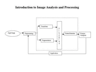
Image Processing Spatial Data MapServer User’s Imagery Browser with JavaScript MapConnector Image Processing Library Raw Imagery
Analysis on the Web HTML Interface With JavaScript MapConnector Web Server Local MapServer Map MapConnector Spatial Analysis Package
Analysis via Web Service ArcIMS feature services Web Server User Interface ArcGIS Web Server Spatial Analysis Package as Web Service
Analysis with ArcIMS Access (SSURGO database) Local: County State: PASDA User Interface MapConnector State: DEP State: DCNR National : National Map PDF Generator
Downloads Download demo CD and presentations at: www.mapconnector.net/wvudemos.htm