Groundwater and the Hydrologic Cycle
520 likes | 802 Vues
Groundwater and the Hydrologic Cycle. Chapter 17. Vasey’s Paradise, GCNP. Oceans Cover >70% of Surface. Oceans are only 0.025% of Mass. Groundwater. Groundwater is liquid water that lies in the subsurface in fractures in rocks and in pore space between grains in sedimentary rocks.

Groundwater and the Hydrologic Cycle
E N D
Presentation Transcript
Groundwater and the Hydrologic Cycle Chapter 17 Vasey’s Paradise, GCNP
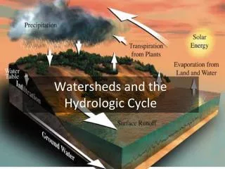
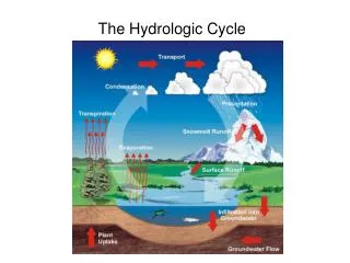
Groundwater • Groundwater is liquid water that lies in the subsurface in fractures in rocks and in pore space between grains in sedimentary rocks. • The Hydrologic Cycle is the evaporation of water from the oceans, transport over the land, precipitation, and return of the water to the ocean.
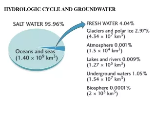
Hydrologic Cycle(x 1000 km3/y) Total ocean mass = 1.4 x 10²¹kg Evaporation = 4.3 x 10¹⁷ kg/y = 0.03% / y
Reservoirs The reservoir of hydrogen in oxygen minerals is many times that of the oceans.
Porosity and Permeability • Porosity is the percentage of open space in a rock. • Permeability is the ability of fluids to flow through rock.
Porosity • Porosity can be as high as: • 50% in loose sand to • 5% in cemented, lithified sandstone, to • near zero in unfractured igneous rocks.
Porosity • Porosity in close-packed identical spheres is about 22%.
Permeability • Permeability depends on the connectivity of the pore space. • Permeable rocks include sandstone and fractured igneous and metamorphic rocks and karst limestone. • Impermeable rocks include shales and unfractured igneous and metamorphic rocks.
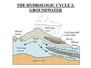
The Water Table • The water table is the natural level of liquid ground water in an open fracture or well. • The water table follows topography. • The unsaturated zone is the region above the water table. • The saturated zone is the region below the water table.
Unsaturated Zone • The unsaturated zone is the region above the water table where pores and fractures are partially filled with water and partly by air. • The pressure in the unsaturated zone is atmospheric. • Conditions are usually highly oxidizing due to the presence of free oxygen in the air and highly reactive due to the presence of water.
Unsaturated Zone • The unsaturated zone is the region above the water table where pores and fractures are partially filled with water and partly by air. • The pressure in the unsaturated zone is atmospheric. • Conditions are usually highly oxidizing due to the presence of free oxygen in the air and highly reactive due to the presence of water.
Saturated Zone • The saturated zone is the region below the water table, where all fractures and pores are filled with water. • The pressure in the saturated zone is hydraulic (= that of the overlying water column). It increases at the rate of 100 atm / km (0.1 atm/m) • At very great depths ( > 2km ) the pores are sealed, and the pressure is that of the overlying rock column (~330 atm / km).
Clicker Question • That subsurface region above the standing water level (water table) where the pressure is that of the atmosphere is called the: • A. Saturated zone • B. Unsaturated zone • C. Oxidation zone • D. Reduction zone • E. Reactive zone.
Clicker Question • That subsurface region above the standing water level (water table) where the pressure is that of the atmosphere is called the: • A. Saturated zone • B. Unsaturated zone • C. Oxidation zone • D. Reduction zone • E. Reactive zone.
Clicker Question • That subsurface region below the standing water level (water table) where the pressure is that of the water column is called the: • A. Saturated zone • B. Unsaturated zone • C. Oxidation zone • D. Reduction zone • E. Reactive zone.
Clicker Question • That subsurface region below the standing water level (water table) where the pressure is that of the water column is called the: • A. Saturated zone • B. Unsaturated zone • C. Oxidation zone • D. Reduction zone • E. Reactive zone.
Rock Units of Differing Permeabilities • An aquifer is a porous and permeable layer through which water can flow easily. • Sandstone • Alluvium • Anaquitard is a layer that retards the movement of water. • Shale • Unfractured igneous or metamorphic rock
Unusual Conditions • A perched water table is isolated from the main water table by a layer of impermeable rock. • An artesian basin is one that is under pressure due to hydraulic head. • The artesian aquifer is usually confined between aquitards. • An artesian well is one that will flow without pumping.
Clicker Question • Those rocks that commonly make the best aquifers are: • A. Granite • B. Schist • C. Shale • D. Sandstone • E. Salt
Clicker Question • Those rocks that commonly make the best aquifers are: • A. Granite • B. Schist • C. Shale • D. Sandstone • E. Salt
Ogallala Aquifer Depletion • Aquifer underlies former dust bowl • Aquifer was artesian when first tapped. • Drilling and pumping greatly increased in last half of 20th century. • The economy is still largely agricultural • Pumping greatly exceeds recharge. • Aquifer is depleted in some regions and nearly depleted in most of the rest. • Agriculture will largely cease in 20 years. • Currently 10 to 15% of US production.
Clicker Question • A groundwater system where the pore pressure exceeds that of the water column to the surface so that water can flow spontaneously to the surface is called: • A. Artesian • B. Confined • C. Karst • D. Depleted • E. Running
Clicker Question • A groundwater system where the pore pressure exceeds that of the water column to the surface so that water can flow spontaneously to the surface is called: • A. Artesian • B. Confined • C. Karst • D. Depleted • E. Running
Ogallala Aquifer Contamination • Pantax Site near Amarillo, TX • Nuclear weapons facility (DoE) • Used TCE was burned in unlined pits • Solvents leaked down to aquifer (~400ft down) • What can be done? • Use surface water.
Karst • Karst topography refers to a surface topography marked by sinkholes, disappearing streams, and small closed drainage basins. • It is an indication of underground drainage in caverns in limestone. • Limestone (Calcite, CaCO3) is dissolved by acids in soil and rainwater to form caverns.
Clicker Question • The rock type underlying most karst drainage systems is: • A. Sandstone • B. Shale • C. Salt • D. Limestone • E. Granite
Clicker Question • The rock type underlying most karst drainage systems is: • A. Sandstone • B. Shale • C. Salt • D. Limestone • E. Granite
Cave Formations • Precipitation of calcite from dripping water saturated in calcite gives rise to formations in caverns • Stalactites hang from the roof. • Stalagmites build up on the floor of the cavern.
Hot Springs and Geysers • Hot springs are caused by the outcrop of hot water heated by local igneous activity or by water that is rising from great depths. • Geysers are caused by hot springs of water at or above the boiling point. Geysers occur in active volcanic regions such as Yellowstone Park (Wyoming), Geysers (California), and Iceland.
Hot Springs in Colorado • Hot springs are caused by the outcrop of hot water heated by local igneous activity or by water that is rising from great depths. • Glenwood Springs • Steamboat Springs • Strawberry Hot Spring • Pagosa Springs • Cottonwood Springs (BV) • Mt Princeton Hot Springs
Clicker Question • An erupting hot spring is called a: • A. Fumarole • B. Solfatara • C. Geyser • D. Mud pot • E. Aquitard
Clicker Question • An erupting hot spring is called a: • A. Fumarole • B. Solfatara • C. Geyser • D. Mud pot • E. Aquitard