Download
1 / 55
550 likes | 910 Vues
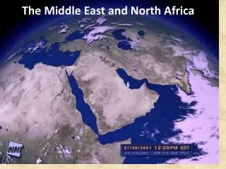
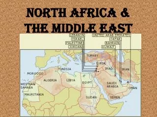
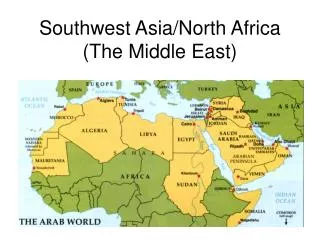
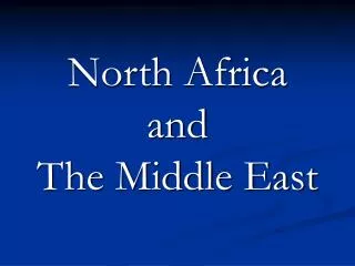
North Africa and The Middle East. North Africa. Morocco Algeria Tunisia Libya Western Sahara Egypt. Turkey Syria Iraq Saudi Arabia Yemen Jordan Lebanon Israel. Cyprus Iran Afghanistan Oman Qatar Bahrain Kuwait UAE. Southwest Asia/ The Middle East. Central Asia.

E N D
North Africa • Morocco • Algeria • Tunisia • Libya • Western Sahara • Egypt
Turkey Syria Iraq Saudi Arabia Yemen Jordan Lebanon Israel Cyprus Iran Afghanistan Oman Qatar Bahrain Kuwait UAE Southwest Asia/ The Middle East
Central Asia • Kazakhstan • Uzbekistan • Turkmenistan • Tajikistan • Kyrgyzstan “stan”means “land of”
The Sahara Desert is a natural boundary • Extends across North Africa • Covers ~3.5 million square miles of land • Little vegetations/ wind erosion common • ~130 degree- 0 degree temperatures
Found in the Sahara • Oasis- an isolated area of vegetation • Erg- windswept sand • Reg- gravel covered plain • Depression- low land • Wadis- dry stream bed which fills with water during the rainy season
Reg Erg Wadi
Negev and Syrian Deserts • Syrian Desert covers portions of Syria, Iraq, Jordan, and Saudi Arabia • Negev Desert is located in Southern Israel
Atlas Mountains • Located in Morocco, Algeria & Tunisia • 1500 miles long • Separate the Atlantic & Mediterranean coastlines from the Sahara Desert • Inhabited by the Berbers (Indigenous people)
Zagros Mountains • Largest mountain range in Iran and Iraq
Elburz Mountains • Located in Iran • Tallest mountain in the Middle East
Arabian Peninsula • Saudi Arabia, Oman, Yemen, Bahrain, Kuwait, UAE, Qatar, Israel, Palestine, Jordan, Syria, SW Iraq • Surrounded by Red Sea, Gulf of Oman, Gulf of Aden, Mediterranean Sea & Persian Gulf • Contains the worlds largest oil reserves
Sinai Peninsula • Located in Egypt • Lies between the Mediterranean Sea to the North and the Red Sea to the South • Joins Africa to Asia
Located between Iran and the Arabian Peninsula Worlds largest source of oil Persian Gulf
Nile River- “Great River” • Longest river in world 4,160 miles long • Flows North to the Mediterranean Sea • Two major tributaries: White Nile and Blue Nile
Nile River Delta at the Mediterranean Sea Nile in Cairo
The Fertile Crescent • Tigris and Euphrates Rivers • Historically referred to as “Mesopotamia” or the “Cradle of Civilization” • Located in Iraq • Headwater is the Taurus Mountains • Mouth is the Persian Gulf
Dead Sea-”Sea of Salt” • Salt lake borders Jordan & Israel • Shoreline- lowest elevation on earth 1385 ft bsl • 38% salt therefore animals cannot flourish
Aral Sea- “Sea of Islands” • Located in Central Asia (Kazakhstan, Uzbekistan) • Formerly the 4th largest lake in world • 10% remains (Russian irrigation, drought, and industrial pollution) • “One of the planet’s worst environmental disasters”
Caspian Sea • Largest lake or inland body of water on Earth • Landlocked by Azerbaijan, Iran, Kazakhstan, Russia, Turkmenistan • Freshwater in the North and more saline in the south
Red Sea • Located between Africa and Asia • Becoming wider as the Arabian and African plates spread • 18 desalinization plants along the sea • Saudi Arabia
Climate • Arid Climate dominates region • Mediterranean Climate along the coast • Semi-Arid Climate between the Sahara and the Coast
The most valuable resource on Earth (especially NA/ ME)Water!!!!
Demographics of SW Asia • Birth Rate = 27/1000 • Death Rate = 6/1000 • Rate of Increase = 2.0% • Infant Mortality Rate = 48/1000 • Fertility Rate = 3.7 • Life Expectancy = 68 • % Urban = 63 • Pop. Density = 114 people per square mile
Egypt – 79 million people Bahrain- 807,000 people
Oil Consumption • The U.S. consumes about 146 billion gallons (about 550 billion liters) of gasoline each year • The U.S. Strategic Petroleum Reserve currently stores about 570 million barrels of oil in underground salt caverns along the Gulf of Mexico. If all imports were cut off this would leave the US with a 60 day supply of oil.
OPEC • One of the most powerful cartels in the world. Collectively it has about three quarters of the worlds discovered and recognized oil reserves. • Headquarters are in Vienna, Austria • These countries control the price of oil by how much they produce each day. Of all internationally traded oil OPEC produces 58% of it. • How many gallons are in 1 barrel of oil? 42 gallons
Top 5 Oil Producing Countries in NAME • Saudi Arabia: 11,150,000 Barrels/day • Iran: 4,231,000 Barrels/day • Iraq: 3,400,000 Barrels/day • UAE: 3,087,000 Barrels/day • Kuwait: 2,682,000 Barrels/day • (United States 9,023,000 Barrels/day)
RELIGION Islam Christianity Judaism