Download
1 / 16
160 likes | 328 Vues
AIRNow Information Services Improved Data Flow to the Air Quality Community. John E. White U.S. Environmental Protection Agency National Air Quality Conference Connecting the Air Quality Community – Working Towards Better Data Access and Sharing March 3 rd , 2009. AIRNow Information Services.

E N D
AIRNow Information ServicesImproved Data Flow to the Air Quality Community John E. WhiteU.S. Environmental Protection AgencyNational Air Quality ConferenceConnecting the Air Quality Community – Working Towards Better Data Access and SharingMarch 3rd, 2009
AIRNow Information Services • Outline • How does AIRNow currently provide information? • AIRNow-Tech • AIRNow Gateway • MapGen maps • The Future – Upcoming changes • Web Services • KMZ (e.g., Google Earth) • ESRI files • RSS messaging • More files including NETCDF • Some Tangible Examples... • Excel/Google Docs • RSS • Google Earth
How AIRNow Delivers Info Today… • Present AIRNow System developed in 2001 • AIRNow-Tech • Web-Based Access to the Data Management System • Pre-defined Queries, graphing, csv downloads • Flexibility/scope is still limited • AIRNow Gateway • Provide one-stop AIRNow information portal • Not there yet • Multiple ASCII files • Only one web service • Maps (using MapGen software) very limited • No way to share geospatial information • OBS file • Limited, not the best source of information
The Future-AIRNow Information Services • Ground-up redesign of the U.S. AIRNow system now underway • Microsoft SQL Server • New GIS-based Mapping System (AIRNow Mapper) • Geospatial, World-wide mapping capability • Map other datasets (e.g., multiple pollutants, aq model outputs) • Data fusion possible • Service Oriented Architecture (SOA) approach • Outputs: RSS, KML, NETCDF, SMS text • Inputs: web service feeds from outside datasets… • Data loggers in the future? • Built with open components/standards • Easily adopted by any state/local agency, country, or province • Portable, flexible, and sustainable • Opportunity for leveraging tools and expertise
AIRNow Information Services • Share and distribute data • Using data standards • data ingest, data distribution, and sharing • Conform to interoperability standards and conventions being developed under: • Group on Earth Observations • World Meteorological Organization • Open Geospatial Consortium (OGC) • Provides flexibility to add new data outputs • Provides ability to control data distribution and sharing
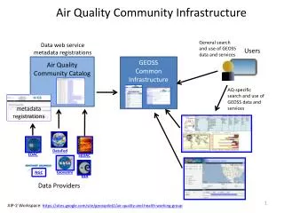
Data Files* Data Files Maps* Image layers* = file = web service = module = data/info transfer New AIRNow System(Conceptual and Functional Design & Data Flow) Data Inputs Processing, QA, Reporting Outputs Administration of the System AIRNow Information Service AIRNow Data Management System (DMS) AIRNow Mapper Web Services* Web Service AIRNow Database *Outputs will conform to standards to promote sharing and interoperability
AIRNow Information Services Concept Other Data Providers United States AIRNow Other Data Consumers Web Services State Agencies Other Nations = monitoring site = data transfer = web service
Mapper Outputs – KML Web Coverage Service – Point: KML Output AIRNow Information Service Outputs • More files • Comma Separated Value (CSV) • NetCDF • ESRI files • RSS • OGC web services • Web Mapping Service • Web Feature Service • Web Coverage Service • Google Earth (KML) files
Using AIRNow Information Services • Expanded AIRNow Gateway Text Files • AQCSV format • used to exchange via XML between AIRNow and AQS Data Mart • Future OBS file replacement? • NetCDF • Climatology, modeling and meteorology applications • GIS • ESRI files • Could provide agencies with shapefiles/gridded data
Using AIRNow Information Services • What is RSS? • Getting fresh updated information to your web browser • Just subscribe or unsubscribe – no email required • Typical examples - weather, stock quotes, news, sports • How can RSS be used by S/L agencies? • No firewall issues • Populate your agency web pages with updated continuous content • forecasts and current conditions • A data feed for your internal applications • How does your public use RSS? • Filter out air quality information for their city • Make widgets, customize home pages • Data feed for value-added applications
RSS AIRNow Gateway Feeds RSS Feeds
Using AIRNow Information Services • Web Services • Allows applications to communicate with one another in a standard way • Like a conversation involving two or more people talking to each other, using some kind of language that they all comprehend • Only data transmitted across the Internet , no additional security risk • No visual interface (text boxes, radio buttons, etc.) • getStockValue(“IBM”) or getCurrentTemp(“Denver”) • Examples • Web Mapping Service • Custom/dynamic maps created at user request (PNG, GIF or JPEG) • Web Feature Service • Returns vector data • Web Coverage Service • Returns gridded data • How can our air quality community use? • Excel spreadsheets • Google docs
Web Service Data Request What is the best way to explain this slide -- ? – esp google docs and applications – examples? AIRNow Database AIRNow web service Google Documents Applications =ImportData("http://staging.sonomatech.com/wcs/wcs.asmx/wcs?service=wcs&Request=GetCoverage&identifier=timepoint&saqscode=" SITE "&uParamID=" PARAMETER "&begin_timesequence=" BEGIN DATE/TIME "&end_timesequence=" END DATE/TIME"&format=csv&uResultBy=0")
Using AIRNow Information Services • KML – Google Earth? • Update file versus dynamically created web coverage service • Open source – lots of applications can use • Easy to develop • Don’t have to build web based GIS system to visualize data • How can I use? • some examples…
Google Map Examples Ohio California