Download
1 / 11
110 likes | 304 Vues
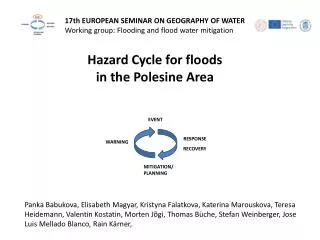
17th EUROPEAN SEMINAR ON GEOGRAPHY OF WATER Working group : Flooding and flood water mitigation. Hazard Cycle for floods in the Polesine Area. EVENT. RESPONSE. WARNING. RECOVERY. MITIGATION/ PLANNING.

E N D
17th EUROPEAN SEMINAR ON GEOGRAPHY OF WATER Working group: Floodingandfloodwatermitigation Hazard Cycle for floods in the Polesine Area EVENT RESPONSE WARNING RECOVERY MITIGATION/ PLANNING Panka Babukova, Elisabeth Magyar, Kristyna Falatkova, Katerina Marouskova, Teresa Heidemann, Valentin Kostatin, Morten Jõgi, Thomas Büche, Stefan Weinberger, Jose Luis Mellado Blanco, Rain Kärner,
17th EUROPEAN SEMINAR ON GEOGRAPHY OF WATER Working group: Floodingandfloodwatermitigation • Event Description • Conditions in most natural areas: • Flood lasts as long as runoff in river is increased • Conditions in most areas with flood protection (burst of embankments): • Flood lasts longer than runoff in river is increased(delayed backflow)
17th EUROPEAN SEMINAR ON GEOGRAPHY OF WATER Working group: Floodingandfloodwatermitigation • Conditions in Po-Delta: • Rivers are supra-elevated • Area lies below the sea-level • Water can not discharge to the sea • True for: • Precipitation • Increased runoff in river (branches of Po) • Burst of embankments Data: S. Piovan Sea level
17th EUROPEAN SEMINAR ON GEOGRAPHY OF WATER Working group: Floodingandfloodwatermitigation Response and Recovery of the floods of 2000 in Po river basin in Northwest of Italy Municipalities that suffered major damages from the October‐November 2000 floods
Flooding of 2000 - Response and recovery 17th EUROPEAN SEMINAR ON GEOGRAPHY OF WATER Working group: Floodingandfloodwatermitigation • Data best-fit and comparable for possible floodings. • Initial response to (attempt to) restore basic living conditions, to clean the debris, to secure the hydrological structure
Flooding of 2000 - Response and recovery 17th EUROPEAN SEMINAR ON GEOGRAPHY OF WATER Working group: Floodingandfloodwatermitigation • Railway recoverynear Turin – more than 2 years • Temporary isolation of smaller townsinthearea • Hydropower plant recovery 6 months • Water supplyinteruptionsfor a week
17th EUROPEAN SEMINAR ON GEOGRAPHY OF WATER Working group: Floodingandfloodwatermitigation Po delta: Lack of management on a river basin level Poor communication and coordination between water management institutions Main problems of flood risk management Mattia Amadio Expensive flood protection (pumping stations, maintenance of embankments) Bad condition of ditches – private owners, no regulations, neglected www.dailymail.co.uk www.hullcc.gov.uk Warning system – not working effectively Low level of public awareness about flood risk • Padova: • Canal network - bad condition of the canals (vegetation, age)regulation of discharge sluices PankaBabukova
17th EUROPEAN SEMINAR ON GEOGRAPHY OF WATER Working group: Floodingandfloodwatermitigation Technicalfloodriskmitigationmeasures Increaseretentioncapacity – emergencyreservoirs, collector of rainwater Reopeningthecanals and maintenance of thedykes and ditches Individualprotectionforthehouses – mobile walls, building specifications (roofretentioncapacity, basementregulation, elevatedfirstfloor) Land architecture protection measures
17th EUROPEAN SEMINAR ON GEOGRAPHY OF WATER Working group: Floodingandfloodwatermitigation Non-technical flood risk mitigation measures Flood risk management on a basin level (according to the EU Water Framework Directive and Floods Directive) Creation of dialog between institutions and distribution of responsibilities within the basin Mattia Amadio • Use existing research • Integration of existing flood hazard and risk maps in spatial planning regulations, insurance and for public Mattia Amadio • Improvement ofthe early warning systems • Raise public awareness and involvement Panka Babukova
Awareness of territorial peculiarities as a pre-condition for the creation of a culture of risk “Natural hazard” or “territorial risk” ? 17th EUROPEAN SEMINAR ON GEOGRAPHY OF WATER Working group: Floodingandfloodwatermitigation Po Delta is a complex territory, resulting from the interaction of human societies and a changing environment. Technical representations of natural hazard, based on calculations (modeling) of flood level, cannot completely explain a complex risky territorial context: vulnerability is increased by human behavior, linked to cultural, social and historical factors Trust in human ability to control and “organize” nature Reclaimed lands