June 29-30, 2012 Derecho
150 likes | 362 Vues
June 29-30, 2012 Derecho. Impacted southern New Jersey, Maryland and Delaware. NWS Mount Holly, NJ. Synopsis.

June 29-30, 2012 Derecho
E N D
Presentation Transcript
June 29-30, 2012 Derecho Impacted southern New Jersey, Maryland and Delaware. NWS Mount Holly, NJ
Synopsis • During the afternoon and evening of Friday June 29, 2012, an intense, long-lived line of thunderstorms raced eastward at nearly 60 mph from the Midwest to the Mid Atlantic coast. In its wake, these storms left behind a swath of destruction that killed at least 20 people, caused millions in property damage, and caused massive power outages in major urban areas along the storm’s path. Meteorologists use the term “derecho” to describe this special type of violent and long-lived windstorm.
What is a Derecho? • Essentially, a "derecho" is a long-lived, rapidly moving line of intense thunderstorms that produces widespread damaging winds in a nearly continuous swath. • By definition, the term “derecho” (spanish for direct or straight ahead) applies to a complex line of thunderstorms that travels a minimum distance of 240 miles or more, and produces a nearly continuous and widespread swath of damaging winds over that distance, with concentrated areas of wind speeds over 58 mph. Surface wind gusts accompanying a derecho can often approach or exceed 100 mph.
2 PM EDT (18Z June 29, 2012) Surface Analysis This map shows the position of the surface cool front across the Midwest, Ohio Valley and the Northeast. The initial developing thunderstorm complex near Chicago was the start of what would quickly grow into the derecho. The derecho then basically tracked along the cool front all the way to the Mid Atlantic coast.
Enhanced Infrared Satellite Image Infrared Satellite Image This image was taken at 9:40 PM EDT Friday evening (0240Z June 30, 2012). Overlaid on this image is the 15-minute sum of lightning cloud to ground strikes between 9:30 PM and 9:45 PM EDT. Nearly 1,400 strikes are depicted on this image as the derecho rips through the Mid Atlantic.
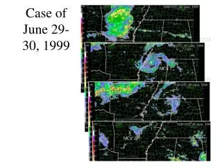
Radar Reflectivity – 9 PM to 3 AM June 29-30, 2012 This is a 6-hour loop from the KDOX Doppler Radar (located in northern Sussex County, DE). This shows the intense derecho approaching from the west, then quickly moving across Maryland, Delaware and southern New Jersey. Note the brighter colors especially across southern New Jersey, where the intense storms caused the widespread damage.
Radar Velocity Data – 9 PM to 2 AM June 29-30, 2012 This is a 5-hour loop from the KDOX Doppler Radar (located in northern Sussex County, DE). The red (brighter) colors is wind moving away from the radar and greens/blues is wind moving toward the radar. The velocities are in knots.
Cloud to Ground Lightning – 9:15 PM to 4:00 AM June 29-30, 2012 This is a 7-hour loop of cloud to ground lightning strikes. One thing to note is the rapid increase in lightning as the storms moved into and across southern New Jersey.
Preliminary Severe Reports Preliminary severe weather reports from June 29th into early June 30th. Wind reports are in blue. Measured wind speeds of 65 knots (75 mph) of more are denoted by black squares.
Peak Wind Gusts Peak wind gusts across the impacted areas were nearly 90 mph. Several locations had measured gusts to or above 60 mph.
Local Impacts • The derecho winds across Maryland’s Eastern Shore and Delaware were produced mostly from an intense gust front that moved well ahead of the rain. • The northern end intensified near Baltimore, MD and then moved across northern Delaware and especially southern New Jersey. • Intense lightning moved across southern New Jersey along with widespread wind gusts of 60 mph to nearly 90 mph. • The intensity and widespread nature of the winds took down numerous trees and power lines. This resulted in hundreds of thousands of customers without power. Some areas did not get power back until at least a week after the storm.
Highlighted Storm Reports (Times approximate) • 11:25 PM – Trees and wires down throughout Talbot County, Maryland. • 12:06 AM – Trees and wires down in the Warwick, MD area (Cecil County). Also, damage to buildings. • 12:15 AM – Numerous trees and power lines down across Cecil County, MD. About 35 roadways with trees down across them. 1 injury. • 12:15 AM – Multiple trees reported down in Middletown, DE (New Castle County). Poles also snapped. • 12:50 AM – Pine tree fell onto a tent causing two fatalities in Parvin State Park (Salem County, NJ).
Highlighted Storm Reports (Times approximate) • 1:00 AM – Numerous trees knocked down in Bridgeton, NJ (Cumberland County). • 1:00 AM – Numerous trees down with roadways blocked in Northfield and Mays Landing (Atlantic County, NJ). • 1:05 AM - Numerous trees and wires down in Absecon, NJ (Atlantic County). At least one tree through a home. • 1:10 AM – Numerous reports of wires down throughout Cape May County, NJ. • 1:30 AM – Widespread number of trees and wires down in and around Absecon, NJ (Atlantic County).
Acknowledgements The wind data and storm reports included in this presentation were obtained via the public, trained spotters, emergency managers, DEOS, NJ Weather Network and Weatherflow.