Download
1 / 19
190 likes | 206 Vues
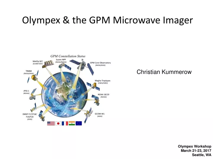
Olympex & the GPM Microwave Imager. Christian Kummerow. 8th Workshop of International Precipitation Working Group 5th International Workshop on Space-based snowfall Measurements 3-7 October 2016 Bologna, I. Olympex Workshop March 21-23, 2017 Seattle, WA. TB database profile #1.

E N D
Olympex & the GPM Microwave Imager Christian Kummerow 8th Workshop of International Precipitation Working Group 5th International Workshop on Space-based snowfall Measurements 3-7 October 2016 Bologna, I Olympex WorkshopMarch 21-23, 2017 Seattle, WA
TB database profile #1 TB observed TB database profile #2 TB database profile #3 ~10 km The GPM radiometer algorithm Step 1: Use GPM Satellite to derive set of “Observed” profiles that define an a-priori database of possible rain structures. Step2: Compare observed Tb to Database Tb. Select and average matching pairs
Assessment of potential databases Rain gauges Dbase w. CMB MS MRMS Dbase w. Ku
TB database profile #1 TB observed TB database profile #2 TB database profile #3 ~10 km The GPM radiometer algorithm Step 1: Over snow, use WSR-88 precipitation (MRMS) to build a-priori database with observed Tb for each constellation sensor. Step2: Compare observed Tb to Database Tb. Select and average matching pairs
The algorithm basics • Is the right answer in the a-priori database? • Did the algorithm find it?
GMI ITE111 Footprints averaged up to 50 x 50 km Plotted are rain rates > 0, liquid only, RQI > 0.9 High bias in the plains still very prominent but if compared across the whole region, including coasts and offshore, continental scale mean rate is pretty similar…. Sign of bias flips over Olympic Peninsula……
November 1st, 2015 Post Frontal convection
November 1st, 2015 Post Frontal convection
November 1st, 2015 Post Frontal convection
November 12th, 2015 Warm Moist Pre-Frontal
November 17th Warm Moist Flow
December 3rd, 2015 Orographically Enhanced Rain
December 8, 2015 Orographic Enhancement of an "Atmospheric River"
December 24th, 2015 “Significant Snowfall" GMI Surface Precipitation GMI Frozen Precipitation
Validation basics • Is the right answer in the a-priori database? • Need 3-D profile of hydrometeor profiles during GMI overpasses • Did the algorithm find it? • Need 3-D profile of hydrometeor profiles during GMI overpasses • Orographic enhancement is hard to detect • Warm rain vs ice phase processes are likely driver of errors. Can WRF simulations provide guidance?