Download
1 / 43
440 likes | 574 Vues
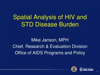
Spatial Analysis of HIV and STD Disease Burden. Mike Janson , MPH Chief, Research & Evaluation Division Office of AIDS Programs and Policy. HIV Prevention Strategy. Assessing effective interventions tell us which strategies will make the most impact.

E N D
Spatial Analysis of HIV and STD Disease Burden Mike Janson, MPH Chief, Research & Evaluation Division Office of AIDS Programs and Policy
HIV Prevention Strategy • Assessing effective interventions tell us which strategies will make the most impact Where should we focus our prevention efforts to make the largest impact with resources we have?
Spatial Analysis Background • Services historically prioritized by Service Planning Area (SPA) • Disease burden geographical differences are not explained by SPA boundaries • The use of GIS allows for small-area analysis and spatial epidemiological techniques • Recent agreements to share HIV and STD case data have allowed for a more accurate picture of overall HIV/STD disease burden
Spatial Analysis Background • Opportunity to examine disease burden without regard to arbitrary boundaries • Analysis conducted without preconceived ideas about where clusters would occur related to SPAs
HIV Positivity Rates by Service Planning Area (SPA), 2007 Source: HIRS, Calendar Year 2007
SPA Planning Model • Assumes that burden of disease is fairly equal across the area of a given SPA
HIV Case Density, 2009, SPA 8 Very Low Density Very High Density Source: 2009 New HIV Cases, HIV Epidemiology Program
Syndemic Planning Model • Focuses on connections among cofactors of disease • Considers those connections when developing health policies • Aligns with other avenues of social change to assure the conditions in which all people can be healthy.
Syndemic Spatial Analysis • Analyze spatial relationships between multiple co-occurring epidemics • HIV • Syphilis • Gonorrhea • Hepatitis
2009 New HIV Cases • 2,036 HIV cases • 1,858 (91.2%) provided some type of residence address • 1,731 (93.2% match rate) could be geocoded to exact location • 127 (6.8%) could be geocoded to the zip code centroid (included homeless and those who gave a PO Box) • Exact location cases were included in the cluster analysis • Centroid cases were not included in the preliminary analysis
2009 STD Cases • Syphilis • 2,641 cases geocoded by residence address • 1,042 (39.5%) reported HIV co-infection (self-report) • 1,597 (60.5%) reported no HIV • 2 cases had missing HIV results • Gonorrhea • 7,918 geocoded by residence address • No HIV results available for this analysis
Cluster Analysis Methodology • Assess spatial distributions of HIV and STD cases • Average Nearest Neighbor (ANN) statistic • Calculates actual mean distance between cases and compares that mean to a hypothetical random distribution • Statistic used to describe the variation in spatial data Are cases clustered or dispersed???
Syphilis Case Distribution
Cluster Analysis Methodology • Conclude that HIV and STD cases are clustered and that the clusters can not be explained by chance • Spatial characteristics are a factor in HIV and STD cases Identify and locate clusters
Cluster Analysis Methodology • Nearest Neighbor Hierarchical Clustering (Nnh) • Used when geographical characteristics are believed to be relevant to the health outcome (Smith, Goodchild, Longley, 2011) • Cases are considered a cluster if they fall within the expected mean distance +/- a confidence interval obtained from the standard error (Mictchell, 2005) • Can be single or multi-level
Nnh Clustering • Single-level • Identifies the largest clusters at the County level • Multi-level • Identifies multiple levels of clusters (County, city area, neighborhood) • Cluster Count Criteria • Minimum 1% of cases
Nnh Cluster Analysis: 2009 New HIV Cases 68.2% of HIV Cases Source: 2009 New HIV Cases, HIV Epidemiology Program
Nnh Cluster Analysis: 2009 Syphilis + HIV Cases* 68.2% of Syphilis-HIV Co-Infection Cases Source: 2009 Syphilis Cases, STD Program *HIV self-reported among Syphilis cases
Cluster Analysis: 2009 Syphilis w/o HIV Cases* 68.2% of Syphilis w/o HIV Cases Source: 2009 Syphilis Cases, STD Program *HIV self-reported among Syphilis cases
n=1,452 83.9% of HIV Cases in LAC Source: 2009 new HIV cases, HIV Epidemiology Program; 2009 new STD cases, STD Program
Northwest Cluster, 2009 HIV and Syphilis Burden Source: 2009 New HIV Cases, HIV Epidemiology Program; 2009 New Syphilis Cases, 2009 HIV Cases, STD Program
East Cluster, 2009 HIV and Syphilis Burden Source: 2009 New HIV Cases, HIV Epidemiology Program; 2009 New Syphilis Cases, 2009 HIV Cases, STD Program
Additional Spatial Factors • Co-factors for HIV • Meth use • Alcohol use • Poverty • Indicators of risk • Community Viral Load
Source: American Community Survey, 5-year estimates, U.S. Census
Getis-OrdGi* calculated at 6,000 foot threshold using the zone of indifference spatial conceptualization Source: American Community Survey, 5-year estimates, U.S. Census
Community Viral Load (cVL) • Population-based measure of community’s viral burden (community = Ryan White patients) • Potential biologic indicator of effectiveness: • Antiretroviral treatment • HIV prevention • Definitions: • Analysis of most recent VL of clients in the RW system • Mean VL: Average of each clients most recent VL
Source: Ryan White Treatment Data, March, 2009 – February ,2010
Source: Ryan White Treatment Data, March, 2009 – February ,2010
Cluster Areas and HIV Testing Sites, 2009 Source: 2009 HIV Testing Sites, OAPP
Cluster Areas and Medical Outpatient Sites, 2009 Source: 2009 Ryan White Medical Outpatient Sites, OAPP
Central Cluster and HIV Testing Sites, 2009 Source: 2009 HIV Testing Sites, OAPP
Next Steps • Analyze additional co-factors • Meth use • Hepatitis B/C • Analyze service allocation and compare with disease burden
Limitations • Spatial Model limited to new cases for 2009 • Assumes that infection occurs within resident case clusters • Co-infection data not included for all HIV cases
Recommendations • Include multiple years of new cases to assess trends • Include prevalence cases • Match STD case data with HIV case data for all HIV cases • Use multi-level clustering to identify smaller clusters within larger clusters
References • Mitchell, Andy. The ESRI Guide to GIS Analysis Volume 2: Spatial Measurements & Statistics. 1st Edition. Redlands (CA): ESRI Press; 2005. 2. de Smith, Michael J; Goodchild, Michael F; Longley, Paul A. Geospatial Analysis: A Comprehensive Guide to Principles, Techniques and Software Tools. 3rd Edition. UK: Splint Spatial Literacy in Teaching; 2011