
Comprehensive Wildfire Property Assessment Documentation Protocol
This protocol outlines the procedure for conducting a detailed wildfire property assessment, including photo documentation for effective evaluation. Begin with a handheld GPS unit showing the GPS time on the first image of the day. Complete a NIST WUI Assessment Form and document the parcel with panoramic images capturing the driveway, burned vegetation, fire direction, and other significant features. Ensure each panoramic sequence starts with a northward shot and follows guidelines on image orientation, capturing key elements while avoiding obstructions. The final image should always document the completed assessment form for comprehensive coverage.

Comprehensive Wildfire Property Assessment Documentation Protocol
E N D
Presentation Transcript
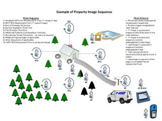
Example of Property Image Sequence Photo Sequence 1) Handheld GPS Unit Showing GPS Time (1st image of day) 2) NIST WUI Assessment Form (1st parcel image) 3) End of Driveway Panoramic 4) Burned Vegetation (Post-Fire) 5) Fire Direction (Post-Fire) 6) Additional Features (Combustibles, Vehicles) 7) Structure(s) Corner Panoramic – as many as required 8) Wildland Property Edge (if applicable) 9) Other Sequences (if applicable) 10) NIST WUI Assessment Form (Last parcel image) • Photo Protocol • Photos should be landscape for all panoramic sequences • Portrait images acceptable for other features • 1st image in a panoramic sequence should be taken in the north direction • 1st image in a panoramic sequence contains photographer’s index finger • Last image in a panoramic sequence contains photographer’s feet • Take enough photos to document entire property (more is better) • Last image on parcel is of first page of completed Parcel Assessment Form #7c #7b #7d #9 #5 #2 & #10 #7a #3 #8 #6b #6a #4 #6c #1
Digital Camera Documentation Illustration #7c #7d #7b #9 #5 #2 & #10 #7a #8 #3 #6c #4 #6b #1 #6a
Digital Camera Documentation Illustration • Photo Protocol • Photos should be landscape for all panoramic sequences • Portrait images acceptable for other features • 1st image in a panoramic sequence should be taken in the north direction • 1st image in a panoramic sequence contains photographer’s index finger • Last image in a panoramic sequence contains photographer’s feet • Take enough photos to document entire property (more is better) • First and Last image on parcel shows Parcel Assessment Form First & Last Image
Digital Camera Documentation Illustration • Photo Protocol • Photos should be landscape for all panoramic sequences • Portrait images acceptable for other features • 1st image in a panoramic sequence should be taken in the north direction • 1st image in a panoramic sequence contains photographer’s index finger • Last image in a panoramic sequence contains photographer’s feet • Take enough photos to document entire property (more is better) • First and Last image on parcel shows Parcel Assessment Form Large & Small Detached Features Linear Features Corner of Structure Panoramic Street Level Panoramic Fire Direction Other Panoramic First & Last Image