Remember Pangaea?
Remember Pangaea?. When did it form? When did it break apart? How?. Rift basin columnar basalt Mt. Tom Nature Trail. Photo by J. Stephen Conn, 2009 (flickr.com). Base of Devils Tower, Wyoming photo by K.Landerholm, 2008 (flickr.com). Devils Tower Wyoming, 2009
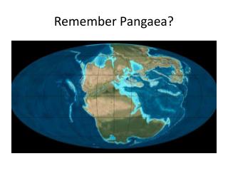

Remember Pangaea?
E N D
Presentation Transcript
Photo by J. Stephen Conn, 2009 (flickr.com) Base of Devils Tower, Wyoming photo by K.Landerholm, 2008 (flickr.com) Devils Tower Wyoming, 2009 J. Stephen Conn (Flickr.com)
Columnar Basalt, Iceland, 2004 photo by Andy Hares (flickr.com) “Church Floor” Columnar Basalt, Iceland 2009 photo by Bri74 (flickr.com)
Mendenhall Glacier, Juneau Alaska, 2007 photo by swanksalot (Seth Anderson) (flickr.com)
Mendenhall Glacier, Juneau, Alaska, 2009 Arthur Chapman (flickr.com)
Glacial Outwash Delta, Spitsbergen, Svalbard 2009. photo by Brian Romans (flickr.com)
Hanaupah Alluvial Fan Death Valley, California Photo by Sjb5 (flickr.com)
The ice age comes, and the ice age goes.Need photos: • Compare quartzite bedrock in hilltowns with quartzite stones brought here by the glacier. • Same thing for other types of hilltown bedrock compared with glacial deposits here of the same type of rock. • Glacial grooves (stria?) in basalt & large-scale smoothing on basalt sheets. • Lake Hitchcock map. Today’s sandplain photos, clay layers from lake bottom, any shoreline features like boulder deposits? • It also might be appropriate to add slides that depict more of the landforms associated with the glacier’s retreat at the end of the ice age. These include: Kettle ponds. Drumlins. Eskers. Glacial terraces.