SLR – ~2.5 mm/yr
50 likes | 186 Vues
More than 60% of Barnstable marsh studied by Redfield in 1972 was short S. alterniflora . 1 With fertilization, S. alterniflora competitively displaces S. patens 2 and the alteration of hydrology caused by the change to S. alterniflora allows it to persist. 3.

SLR – ~2.5 mm/yr
E N D
Presentation Transcript
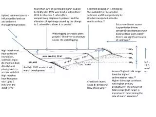
More than 60% of Barnstable marsh studied by Redfield in 1972 was short S. alterniflora.1 With fertilization, S. alterniflora competitively displaces S. patens2and the alteration of hydrology caused by the change to S. alterniflora allows it to persist.3 Sediment deposition is limited by the availability of suspended sediment and the opportunity for it to be transported onto the marsh surface.10 Upland sediment source – influenced by land use and sediment management practices Estuary sediment source Suspended sediment concentration decreases with distance from open water.6 Storms are significant source of sediment.6 Waterlogging decreases plant growth.9 The driver is whatever causes the waterlogging. High marsh must have sufficient inundation, sediment input (to maintain bulk density), and plant growth to accrete with SLR. High marshes have kept pace with up to 7 mm/yr in the short term.5 SLR – ~2.5 mm/yr Redfield 1972 model of salt marsh development Areas of highest tidal range have the highest sedimentation rates.4,6 Higher tide range correlates with higher primary productivity.7 The amount of tidal energy (tide range) is important in determining the rate of marsh accretion.8 Creekbank levees cause bi-directional flow of soil water3
References 1 Redfield 1972 2 Bertness et al 2002 3 Hemond and Fifield 1972 4 Harrison and Bloom 1977 in Stumpf 1983 5 Good et al. 1982 6 Stumpf 1983 7 Steever 197 8 Stevensen et al. 1986 9 Mendelssohn ans Seneca 1979 10 Reed 1989
Conversion from farmland to forest and residential may have reduced input. More than 60% of Barnstable marsh studied by Redfield in 1972 was short S. alterniflora.1 With fertilization, S. alterniflora competitively displaces S. patens2and the alteration of hydrology caused by the change to S. alterniflora allows it to persist.3 Sediment deposition is limited by the availability of suspended sediment and the opportunity for it to be transported onto the marsh surface.10 Upland sediment source – influenced by land use and sediment management practices Estuary sediment source - Suspended sediment concentration decreases with distance from open water.6 Storms are significant source of sediment.6 High nutrient concentrations in NR may increase S.a. prevalence. Narrow River marsh doesn’t seem to be much different. Waterlogging decreases plant growth.9 The driver is whatever causes the waterlogging. High marsh must have sufficient inundation, sediment input (to maintain bulk density), and plant growth to accrete with SLR. HMs have kept pace with up to 7 mm/yr in the short term.5 SLR – ~2.5 mm/yr Redfield 1972 model of salt marsh development Areas of highest tidal range have the highest sedimentation rates.4,6 Higher tide range correlates with higher primary productivity.7 The amount of tidal energy (tide range) is important in determining the rate of marsh accretion.8 Looks like the levee forms along the main channel at NR. SLR has been in the range that marshes can keep pace with, so why are they not in Narrow River? Creekbank levees cause bi-directional flow of soil water3 Tide range in the Narrow River may have been compressed by the flood tidal shoals reducing tidal energy and sediment subsidy
Natural Ditch w/levee This looks like a problem, but it occurs where the marsh is not artificially ditched. Surface flow toward and away from creek The natural levee would hold water on a declining tide allowing the sediment to deposit on the marsh Subsurface flow Constructed Ditch w/out levee Surface flow toward and away from creek There is no levee to slow the release of water so these ditches would increase the removal of water AND sediment from the marsh, decreasing its natural resilience. This looks like “typical” high marsh vegetation, but it occurs where the marsh has unnatural ditches. If the pond wasn’t there, the pond would be continuous along the back of the marsh. Subsurface flow This looks like a creekbank levee along the main channel of the Narrow River – because the marsh is relatively new and not very wide.
The goal is resilience – it may be more important for resilience to re-establish the historic high and low tide levels – if they have been artificially reduced by the sand in the flood tidal shoals - to increase the ability of the system to keep pace with sea level rise by bringing more tidal energy and sediment into the system. It seems like it’s just as likely that the problem is not enough tidal range as too much (e.g. accelerated sea level rise). • The summary seems to indicate that areas with straight unnatural ditches are the target and areas with pannes and ponds are in need of restoration. How does this compare to Figures 13 and 37 in Redfield that show the amount of pannes in the unditched marsh? • Sediment trapping rates are related to the amount of time the marsh is submerged – so ditches may decrease the sediment contribution in the long run. That would make restoring ditches the opposite of restoring resilience. • If ditches drain the water off the marsh faster, there is less time for sediment to settle. • If the problem is sediment supply and ditches reduce sediment supply, restoring ditches reduces the capacity of the marsh to keep pace with sea level rise.