Download
1 / 34
340 likes | 460 Vues
The Australian Curriculum. “GEOGRAPHY BEYOND THE CLASSROOM”. http://youtu.be/ri0_ijyFni4. Rationale.

E N D
The Australian Curriculum • “GEOGRAPHY BEYOND THE CLASSROOM”
Rationale • Geography is a structured way of exploring, analysing and understanding the characteristics of the places that make up our world, using the concepts of place, space, environment, interconnection, sustainability, scale and change. • It addresses scales from personal to the global and time periods from a few years to thousands of years.
A student can learn to fill in a map by memorising states, cities, countries, etc., and can complete the task with a high level of accuracy. But if the boundaries are removed, the problem becomes much more difficult. There are no concepts supporting the student's information. • An expert who understands that borders often developed because natural phenomena (like mountains or water bodies) separated people, and that large cities often arose in locations that allowed for trade (along rivers, large lakes, and at coastal ports) will easily outperform the novice.
The more developed the conceptual understanding of the needs of cities and the resource base that drew people to them, the more meaningful the map becomes. • Students can become more expert if the geographical information they are taught is placed in the appropriate conceptual framework. • Bransford, Brown & Cocking, 2000, p. 17.
A sense of wonder, curiosity and respect about places, people, cultures and environment A deep geographical knowledge of their own locality, Australia, the Asia region and the world A capacity to be competent, critical and creative users of geographical inquiry methods and skills An ability to think geographically, using geographic concepts Aims (Studentsdevelop) As informed, responsible and active citizens who can contribute to the development of an environmentally and economically sustainable, and socially just world.
Content structure • Geography is organised into two related strands: • Geographical Knowledge and Understanding • Knowledge is dynamic and its interpretation can be contested. • Facts, generalisations, principles, theories, models • Understanding is the ability to see relationships between aspects of knowledge, construct explanatory frameworks and apply these to new situations. • Geographical Inquiry and Skills • Geographical Inquiryis a process by which students learn about and deepen their understanding of geography. • Geographical Skills are the techniques that geographers use in their investigations, both in fieldwork and in the classroom.
Stages of an investigation • Observing, questioning and planning • Collecting, recording, evaluating and representing • Interpreting, analysing and concluding • Communicating • Reflecting and responding
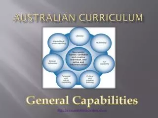
Concepts to develop geographical understanding Place Space Environment Interconnection Sustainability Scale Change
Concept development • Prep - Year 2 • The curriculum explores the geography of their lives and their own places. • Students are introduced to the concept of interconnections, in Year 2, when learning how they are connected to places throughout the world • Skills introduced: observing and describing the features of places, drawing a map, using directional language, understanding distance and interviewing relatives. • Year 3 - 4 • Shift from exploration to more purposeful investigation. • Students learn to describe and compare the environmental and human characteristics of places in different locations at the local, regional and national scale. • Skills introduced: use of aerial photographs and satellite images, construction of simple graphs and the interpretation of maps.
Years 5 - 6 • Students become more critical, analytical and evaluative in their thinking. • They are increasingly aware of the wider community and are learning to take on individual and group responsibilities. • Skills introduced: interpreting spatial distributions, comparing places, making and interpreting graphs, constructing large- and small-scale maps, and using spatial technologies and information and communication technologies. • Years 7 - 10 • Students are able to work with more abstract concepts and consider increasingly complex ideas, and are keen to debate alternative answers and interpretations. • Skills introduced: analysing and interpreting geographical data and information, using spatial technologies and other digital techniques, and developing reasoned arguments based on evidence to support conclusions.
https://det-school.eq.edu.au/resources/c2c/scope-sequence/geounderstanding.htmlhttps://det-school.eq.edu.au/resources/c2c/scope-sequence/geounderstanding.html
Links to Australian Curriculum Geographers regard fieldwork as a vital instrument for understanding our world through direct experience, for gathering basic data about this world, and as a fundamental method for enacting geographical education. The Australian Curriculum goes on to highlight the importance of fieldwork in its implementation: “Geography uses an inquiry approach to assist students to make meaning of their world. It teaches them to respond to questions in a geographically distinctive way, plan an inquiry; collect, evaluate, analyse and interpret information; and suggest responses to what they have learned. They conduct fieldwork, map and interpret data and spatial distributions, and use spatial technologies. Students develop a wide range of general skills and capabilities, including information and communication technology skills, an appreciation of different perspectives, an understanding of ethical research principles, a capacity for teamwork and an ability to think critically and creatively. These skills can be applied in everyday life and at work”.
BUEEC offers powerful first hand learning experiences that support teachers in the “Geographical Inquiry and Skills” strand of the National Curriculum
What does fieldwork look like? • Fieldwork can be ‘short and sweet’ or an all day excursion Around the school Local community Excursion Virtual
How can EECs incorporate meaningful hands on activities to meet the curriculum requirements?Where are there opportunities in the C2C for EECs to meet the curriculum requirements?
Some ideas..... • From the ‘Toolkit’ • Field sketch / sketch map • Biodiversity survey • Land use mapping / transect ---> Google maps • Annotated photo / sketch ---> Skitch • User survey • “Place” circle • Floodlines • Decision making matrix
Where can these skills support the Geography curriculum / C2C?
Year One • C2C Unit One: How do people use places? • Students develop the concept of place through studies of what places are like and how their features have changed. • Skills • Sketching • Land use survey (Google Maps) • Land use survey (natural, managed & constructed) • Annotate photos / maps ---> Skitch • C2C lessons - Lesson 2, 3, 5, 6, 8 (includes assessment)
Year 8 • C2C Unit One: Landforms and landscapes • Focuses on investigating geomorphology through a study of a landscape and their landforms. • Skills • Sketching • Land use survey (Google Maps) • Coastal land use survey (natural, managed & constructed) • Annotate photos / maps ---> Skitch • Water quality testing • Human impact survey • C2C lessons - Lesson 19, 20, 21
Year 10 • C2C Unit Two: Environmental change and management • Focuses on investigating environmental geography through an in-depth study of specific environment (Sandgate foreshore) • Skills • Coastal water level survey • Flood map analysis • Annotate photos / maps ---> Skitch • Housing sketch / survey • Collaborative evaluation ---> Decision-making matrix
Helpful resources.... • www.geogspace.edu.au • www.qsa.qld.edu.au • www.rgs.org • http://www.scoop.it/u/geography-teachers-association-of-victoria-inc • https://www.youtube.com/playlist?list=PLABCB6F1476A5E744 • http://www.brisbane.qld.gov.au • http://infogr.am/ • www.ozcoasts.gov.au • www.scribblemaps.com • https://data.qld.gov.au/maps-geospatial/qld-globe • Geography - for those new to teaching the subject (NSW Education & Training) • Keys to Fieldwork
GeogSpace • http://www.geogspace.edu.au • GeogSpace has been designed to provide materials to support primary and secondary teachers in implementing the Australian Curriculum: Geography. • The site is split into two major resource sections: • Core units • - includes illustrations that give classroom ready ideas and resources • Support units • - includes illustrations of practice designed to support teachers' professional learning and provide guidance, information and resources.
Scoop it - GTAV • http://www.scoop.it/u/geography-teachers-association-of-victoria-inc
Scribble maps • www.scribblemaps.com
QLD Studies Authority • www.qsa.qld.edu.au • Prep - Year 10 • P - 10 Geography • Resources
At your centre...... Which current activities address aims of the Geography curriculum?Are there opportunities to further address the aims?
Contact details..... • mdavi544@eq.edu.au • 3552 7111 • www.urbaneec.eq.edu.au • Thank you for your time