Download
1 / 1
10 likes | 181 Vues
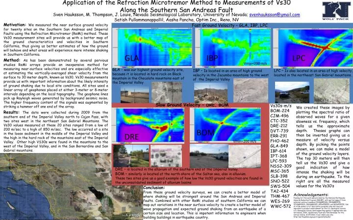
Sven Hauksson , M. Thompson, J. Louie, Nevada Seismological Laboratory, University of Nevada; svenhauksson@ gmail.com Satish Pullammanappallil , Aasha Pancha , Optim Inc., Reno, NV. Fast Ground Velocity – GLA, IBP, LPC. GLA. IBP. LPC. Vmin =200 m/s.

E N D
Sven Hauksson, M. Thompson, J. Louie, Nevada Seismological Laboratory, University of Nevada; svenhauksson@gmail.com SatishPullammanappallil, AashaPancha, Optim Inc., Reno, NV Fast Ground Velocity – GLA, IBP, LPC GLA IBP LPC Vmin=200 m/s GLA - was our highest ground velocity site, because it is located in hard rock on Black mountain in the Chocolate mountains east of the Imperial Valley IBP – Is located in an area of high ground velocity in theJacumba mountains to the west of the Imperial Valley LPC – Is also located in an area of high velocity, located in the northeast San Gabriel mountains. Application of the Refraction MicrotremorMethod to Measurements of Vs30Along the Southern San Andreas Fault Slow Ground Velocity – DRE, BOM Vs30s-m/s BOM-224 CJM-496 CTC-352 DRE-212 DVT-739 ERR-291 FHO-462 GLA-849 IBP-614 IPT-368 LPC-593 NSS2-309 MSC-365 SLB-398 SNO-522 SWS-504 TA2-434 THM-467 WES-269 WWC-572 We created these images by plotting the spectral ratio of observed waves for a given slowness vs. frequency, which tells us the approximate depth. Theses graphs can then be inverted giving us a measure of velocity versus depth. By picking the points shown, we can make a model of the ground velocity layers. The top 30 meters will then tell us the Vs30 and give a good indication of how intense the shaking will be during an earthquake.To the right are all the measured values for the Vs30’s Motivation: We measured the near surface ground velocity for twenty sites on the Southern San Andreas and Imperial Faults using the Refraction Microtremor (ReMi) method. These Vs30 measurement sites will provide us with a better map of the ground characteristics and velocities in Southern California, thus giving us better estimates of how the ground will behave and what areas will experience more intense shaking in Southern California. Method: As has been demonstrated by several pervious studies ReMi arrays provide an inexpensive method for measuring near-surface velocities and are especially effective at estimating the vertically-averaged shear velocity from the surface to 30 meter depth, known as Vs30.Vs30 measurements provide us with important information about the likely intensity of ground shaking due to local site conditions. All sites used a linear array of geophones placed at either 3-meter or 8-meter intervals depending on the local topography. The geophone lines pick up Rayleigh waves generated by background seismic noise. The higher frequency content of the signals was augmented by striking a hammer off one end of the array. Results:The data were collected during 2009 from the southern end of the Imperial Valley north to Cajon Pass, with two sites west in the northeast San Gabriel Mountains. The Vs30 values measured at these 20 sites ranged from a low of 200 m/sec to a high of 850 m/sec. The low occurred at a site in the loose sediment in the middle of the Imperial Valley and the high in the hard rock of the mountains east of the Imperial Valley. Other high VS30s were found in the mountains to the west of the Imperial Valley, and in the San Bernardino and San Gabriel mountains. BOM DRE Vmin=200 m/s DRE – is located in the alluvium of the southern end of the Imperial Valley. BOM – similarly is located at the north shore of the Salton sea, also in alluvium. These two sites give us a good example of how low the Vs30 ground velocities are found in the unconsolidated sediment of alluvium basins Conclusion: From these ground velocity surveys, we can create a better model of where shaking will be strongest around the San Andreas and Imperial faults.Combined with other ReMi studies of southern California we can map out variations in the near surface velocity to create a better model of wave propagation and expected ground shaking from an earthquake of a certain size and location. This is impotent information to engineers when building buildings in earthquake country. Acknowledgements: Funding for this work was provided by the National Earthquake Hazards Reduction Program (NEHRP), with partial support from external contract numbers 03HQGR006D, 05HQGR0078, 07HQGR0029, 08HQGR0015, G09AP00050, and G09AP00051. Use of trade names is for descriptive purposes only and does not represent a product endorsement by the U.S. Geological Survey. U.S. Geological Survey (and supporting agency if appropriate-see list below), 2006, Quaternary fault and fold database for the United States, 8/24/2010, from USGS web site: http//earthquakes.usgs.gov/regional/qfaults/