Download
1 / 27
270 likes | 418 Vues
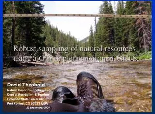
Robust sampling of natural resources using a GIS implementation of GRTS. David Theobald Natural Resource Ecology Lab Dept of Recreation & Tourism Colorado State University Fort Collins, CO 80523 USA 23 September 2004. CR - 829095. Funding/Disclaimer.

E N D
Robust sampling of natural resources using a GIS implementation of GRTS David Theobald Natural Resource Ecology Lab Dept of Recreation & Tourism Colorado State University Fort Collins, CO 80523 USA 23 September 2004
CR - 829095 Funding/Disclaimer • The work reported here was developed under the STAR Research Assistance Agreement CR-829095 awarded by the U.S. Environmental Protection Agency (EPA) to Colorado State University. This presentation has not been formally reviewed by EPA. The views expressed here are solely those of the presenter and STARMAP, the Program (s)he represents. EPA does not endorse any products or commercial services mentioned in this presentation.
Practical sampling needs • Most information for least cost • Sample some areas with higher probability than others • Some features are more important than others • Higher uncertainty of knowing about particular situations • Some locations are more difficult (time, $) to access than others • Flexibility • In-the-field decisions (e.g., access denied, extra time) • Changes in funding (+ or -) for current project • Subsequent projects (additional funding) augment existing dataset (but often different study area) • GRTS algorithm (Stevens 1997; Stevens and Olsen 1999; Stevens and Olsen 2004)
Why GIS framework? • Spatial data is needed to as input to describe population (frame) • Spatial data used to describe strata, to describe inclusion probabilities, including continuous variables (e.g., terrain) • Ability to sample point, line, and area-based ecological resources • Flexibility in adjusting input to alter sampling design • Visualize sampling design in relation to other geographic data: (e.g., accessibility, ownership) • Large, broad user base of GIS technology
Existing GIS-based sampling • Sampling in ArcView v3, ArcGIS v8, v9 • Typically simple random sampling (e.g., random x, y constrained to polygon of study area) • GStat (www.gstat.org):Pebesma and Wesseling. 1998. Gstat, a program for geostatistical modeling, prediction and simulation. Computers and Geosciences 24(1):17-31. • Traditional: stratified, simple random sampling • r.le tools for GRASS • Stratified sampling
Ecological resource types • Areas (e.g., lakes, land cover patches) • Discrete – represent as point shapefile, GRID with single cell • Convert to centroid or labelpoint then to GRID • Tesselate surface: e.g., watersheds, 8-digit HUCs • Discontinuous: all lakes in Oregon • Continuous – represent as polygon, GRID as zones • Patches of vegetation types • Variation of water clarity within selected lakes • Estuarine resources • Area bias? • Lines (e.g., streams, roads) • Discrete – represent as point shapefile, GRID with single cell • Individual stream reaches • 100’ segments • Continuous • All possible locations on stream network • Points (e.g., individual trees, lakes) • Discrete • all lakes in Oregon
Population (MASK: 1/Nodata) Inclusion Prob. (01) Samples (point shapefile) Sample
Population (MASK: 1/Nodata) Inclusion Prob. (01) Strata (01) Env. gradient (e.g., moisture) Special resource (e.g., riparian areas) Samples (point shapefile) Sample
Processing steps • 1. Input • raster or GRID of frame, inclusion probabilities • get spatial extent, grain (resolution), study area (inside, outside, holes) • 2. compute number of quad-levels, L • 3. generate random permuted 1-4 labels at each L • 4. add levels together to create reverse-ordered address • 5. compute sequential list order • 6. threshold against inclusion probabilities • 7. convert raster to point shapefile
Level 1 3 1 2 4
Level 2 1 1 3 3 4 2 2 4 1 1 3 3 4 2 4 2
Summary • Flexibility of input data: point, line, area • Continuous (gradients) and discrete (strata) inclusion probabilities • Visualization of sample design • Can modify inclusion probability based on accessibility constraints • Develop map of “inferred population” • ArcGIS tool
Distribution plans • Currently alpha test phase • Beta testing January 2005 • Release Spring/Summer 2005
This research is funded by U.S.EPA – Science To Achieve Results (STAR) Program Cooperative Agreement This research is funded by U.S.EPA – Science To Achieve Results (STAR) Program Cooperative Agreement This research is funded by U.S.EPA – Science To Achieve Results (STAR) Program Cooperative Agreement This research is funded by U.S.EPA – Science To Achieve Results (STAR) Program Cooperative Agreement This research is funded by U.S.EPA – Science To Achieve Results (STAR) Program Cooperative Agreement # CR - 829095 # CR - 829095 # CR - 829095 # CR - 829095 # CR - 829095 Thanks! • Comments? Questions? • STARMAP: www.stat.colostate.edu/~nsu/starmap • GIS-GRTS tools in ArcGIS: email davet@nrel.colostate.edu Funding/Disclaimer: The work reported here was developed under the STAR Research Assistance Agreement CR-829095 awarded by the U.S. Environmental Protection Agency (EPA) to Colorado State University. This presentation has not been formally reviewed by EPA. The views expressed here are solely those of the presenter and STARMAP, the Program (s)he represents. EPA does not endorse any products or commercial services mentioned in this presentation. Funding/Disclaimer: The work reported here was developed under the STAR Research Assistance Agreement CR-829095 awarded by the U.S. Environmental Protection Agency (EPA) to Colorado State University. This presentation has not been formally reviewed by EPA. The views expressed here are solely those of the presenter and STARMAP, the Program (s)he represents. EPA does not endorse any products or commercial services mentioned in this presentation. Funding/Disclaimer: The work reported here was developed under the STAR Research Assistance Agreement CR-829095 awarded by the U.S. Environmental Protection Agency (EPA) to Colorado State University. This presentation has not been formally reviewed by EPA. The views expressed here are solely those of the presenter and STARMAP, the Program (s)he represents. EPA does not endorse any products or commercial services mentioned in this presentation. # CR - 829095 # CR - 829095 # CR - 829095